
Mud Creek topographic point clouds

Detailed Description
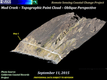
Imagery shows topographic point clouds from photos, first from September 11, 2015 courtesy of California Coastal Records Project, second from March 8, 2017 (USGS photo), third from May 19, 2017 (USGS photo), and fourth from May 27, 2017 (USGS photo) 7 days following the catastrophic Highway 1 landslide. Last image shows the change in topography from the 2015 photo til the May 27 photo, with deep red colors showing greater loss of elevation (up to 40 meters lost) and deep purples showing the greater increase in elevation (up to 40 meters gained).
Provisional Data Subject to Revision
Sources/Usage
Public Domain.