
Nearshore survey of San Ysidro Creek

Detailed Description
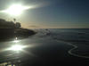
Two USGS scientists operate personal watercraft equipped with sonar and GPS along the beachfront off San Ysidro Creek, near Fernald Point in Montecito, California. They will use the data collected to create bathymetric (depth) maps. Collecting these data on a seasonal basis over many years provides a detailed picture of how the coastline reacts to changes in waves and sediment input. Results will be incorporated into computer models that forecast coastal change. Such models directly help California communities develop plans for how to protect their coastlines.
Sources/Usage
Public Domain.