
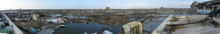
Panoramic photo, Banda Aceh

Detailed Description
Panoramic photo of Banda Aceh, Sumatra, on January 21, 2005 reveals severe damage due to both earthquake and the resulting tsunami on December 26, 2004. A team of tsunami scientists visited Sumatra in order to collect data about the recent tsunami. Data collected includes characteristics of sand, mud, and soil (sediment) deposits carried by tsunami waves, and high water marks on buildings that show the height of those tsunami waves. The scientists will use the data to compare to old sediment deposits found in areas prone to tsunamis, in hopes of learning more about the older tsunami events. Such information is a key to inform communities around the world about potential, future events that may threaten them.
Sources/Usage
Public Domain.