
Postfire debris-flow hazard assessment viewer

Detailed Description
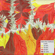
A screenshot showing the USGS postfire debris-flow hazard assessment viewer. The dashboard allows users to view or download postfire debris-flow hazard assessment data. The points on the map show the burn area locations where the USGS conducted hazard assessments from 2013-2025.
Sources/Usage
Public Domain.
Related
Postfire debris-flow hazard maps
Wildfires can dramatically alter how water moves across the landscape. As a result, even modest rainstorms can trigger dangerous flash floods and debris flows in steep burned areas. In response, the USGS produces postfire debris-flow hazard assessments for recently burned areas. These hazard assessments estimate the likelihood, volume, and combined hazard of debris-flows in recently burned. This...

Postfire debris-flow hazards
Wildfires can dramatically alter how water moves across the landscape. After a fire, vegetation is removed and soil properties change, reducing the ground’s ability to absorb rainfall. As a result, even modest rainstorms can trigger dangerous flash floods and debris flows in steep burned areas. Postfire debris flows are fast-moving mixtures of water, mud, rocks, and vegetation that can surge...
Related
Postfire debris-flow hazard maps
Wildfires can dramatically alter how water moves across the landscape. As a result, even modest rainstorms can trigger dangerous flash floods and debris flows in steep burned areas. In response, the USGS produces postfire debris-flow hazard assessments for recently burned areas. These hazard assessments estimate the likelihood, volume, and combined hazard of debris-flows in recently burned. This...
Postfire debris-flow hazards
Wildfires can dramatically alter how water moves across the landscape. After a fire, vegetation is removed and soil properties change, reducing the ground’s ability to absorb rainfall. As a result, even modest rainstorms can trigger dangerous flash floods and debris flows in steep burned areas. Postfire debris flows are fast-moving mixtures of water, mud, rocks, and vegetation that can surge...