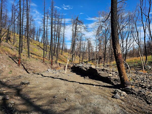
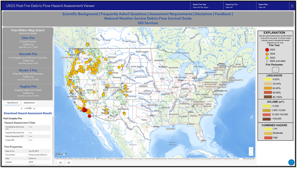
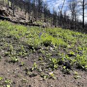
A debris-flow fan near the outlet of the North Fork Cedar Creek in the South Fork Fire burn area. Floods and debris flows occurred during rain events following the summer wildfire. This drainage is located near the center of the burn area and the photo was taken approximately 4 months following the wildfire.
2021 Muckamuck Fire burn area
Okanogan County, Washington
2020 Cameron Peak Fire burn area
Roosevelt National Forest, Colorado
2020 Dolan Fire
Los Padres National Forest, California
Wildfires can significantly alter the way water interacts with the landscape to the extent that even modest rainstorms can produce dangerous flash floods and debris flows. Recent fires in the western U.S. have impacted hundreds of thousands of acres of steep land, much of it public, making it susceptible to increased erosion and debris-flow activity. With the risk of severe wildfires continuing to rise and more development happening in fire-prone areas, it’s important to develop tools to understand the potential hazards posed by debris flows in recently burned areas.
This project aims to create quick and accurate ways to evaluate postfire debris-flow hazards. It also uses applied research to better understand the processes that control post-fire debris-flow initiation and growth. Federal, state, and local agencies need reliable scientific information about these hazards to help reduce the impact of wildfires on people, their homes, and the environment.
What is a postfire debris flow?
Debris flows, sometimes called mudslides by the media, carry much more than just mud. They are concrete-like mixtures of mud, water, boulders, vegetation, and other debris that move downslope faster than a person can run. They may travel great distances outside of the burn area, posing a significant risk to life and property.
Burned landscapes are particularly susceptible to debris flows because wildfire removes vegetation and alters soil properties, decreasing the ground's ability to absorb rainwater. These changes to the landscape mean that rainfall can runoff almost instantly, picking up mud, trees, and boulders as it travels downslope. The addition of debris to the rainwater increases the height of the flows, making them more dangerous and destructive than flash floods.
Debris flows are triggered intense bursts of rainfall and can happen during the first few minutes of the first storm following a wildfire.
A postfire debris flow triggered by intense rainfall on January 20, 2017, in the area burned by the 2016 Fish Fire, Los Angeles County, California.

USGS Postfire Debris-Flow Hazard Assessments
The USGS conducts postfire debris-flow hazard assessments for select fires in the Western U.S. These assessments use information about watershed properties, rainfall characteristics, and soil properties to answer a few key questions:
What burned watersheds are most susceptible to debris flows?
During what types of rainstorms are debris flows likely to be triggered?
How much mud and other debris are these flows capable of carrying?
Click the image below to access the postfire debris-flow hazard assessment dashboard. You can use the dashboard to view or download the data for all recent postfire hazard assessments conducted by the USGS.

More information about hazard assessments
Frequently asked questions
Scientific Background
GIS Services
Request an assessment
Learn more about postfire debris flows
RECOVERY
How long does the hazard last?
As the burn area recovers and the landscape returns to prefire conditions the level of debris-flow hazard decreases. Understanding this recovery process and how debris-flow hazards change in the years following the fire is an active area of research at the USGS.
Use the link below to learn more about fire recovery and postfire debris flows.

RUNOUT
How far can flows travel?
Understanding how far debris flows can travel and what the impacts may be is one of the most important questions we face to effectively protect life and property from debris-flow hazards.
Use the link below to learn more about debris-flow runout research at the USGS.
MONITORING
How well do our hazard models work?
Monitoring stations are installed in select burn areas to better understand the processes that control postfire debris-flow initiation and growth.
Use the link below to learn more about postfire watershed monitoring at the USGS.

Below is a list of science sites associated with this project.
Scientific Background
Early Warning System
Inventory of debris flows in burned (2020-2022) and unburned (1995-2020) areas in the western Cascade Range of Oregon
Postfire erosion estimates for large California wildfires that occurred between 1984 and 2021
Compilation of runoff-generated debris-flow inventories for 18 fires across Arizona, California, Colorado, New Mexico, Utah, and Washington, USA
Postfire Debris-Flow Database (Literature Derived)
Compilation of runoff-generated debris-flow inventories for 17 fires across Arizona, California, Colorado, New Mexico, and Washington, USA
Field-verified inventory of postfire hydrologic response for the 2020 CZU Lightning Complex, River, Camel, and Dolan Fires following a 26-29 January 2021 atmospheric river storm sequence
Tadpole Fire Debris Flow and Wood Collector Measurements May 2021
Tadpole Fire Field Measurements following the 8 September 2020 Debris Flow, Gila National Forest, NM
Field-verified inventory of postfire debris flows for the 2021 Dixie Fire following a 23-25 October 2021 atmospheric river storm and 12 June 2022 thunderstorm
Debris-flow and Flood Video Files, Chalk Cliffs, Colorado, USA, 2019
Debris-flow and Flood Video Files, Chalk Cliffs, Colorado, USA, 2015
Post-wildfire debris-flow monitoring data, 2019 Woodbury Fire, Superstition Mountains, Arizona, USA November 2019 to February 2020
Postfire Debris Flow Science Infographic
Post-wildfire debris flow: 2016 Fish Fire, Las Lomas Canyon
The June 2016 Fish Fire burned over 12 km^2 in Los Angeles County, California. After the fire, the USGS installed an automated rain-triggered camera to monitor post-wildfire flooding and debris flow in a small canyon above the Las Lomas debris basin in Duarte. This video shows the peak flow triggered by an intense rainstorm on January 20, 2017.

A debris-flow fan near the outlet of the North Fork Cedar Creek in the South Fork Fire burn area. Floods and debris flows occurred during rain events following the summer wildfire. This drainage is located near the center of the burn area and the photo was taken approximately 4 months following the wildfire.

Mud- to boulder-sized sediment fill a channel in the 2024 South Fork Fire burn area. The sediment was deposited by flooding and debris flows during rain events following the summer wildfire. The coarsest material (including several large boulders) was deposited on the south side of the channel, forming a debris-flow levee.

A mud- to boulder-sized debris-flow deposit in the South Fork Fire burn area, New Mexico. Flooding and debris-flows occurred as a result of rain events shortly following the summer wildfire. This photo was taken in the South Fork Cedar Creek drainage near the center of the burn area approximately 4 months following the wildfire.
A boulder-rich postfire debris-flow deposit in the 2024 Salt fire burn area. Flooding and debris flows occurred near Ruidoso, New Mexico during rain events shortly following the 2024 wildfires. This photo was taken in Bear Canyon, on the Mescalero Reservation, near the central portion of the burn area.

A poorly-sorted, debris-flow levee deposited during a rain event following the 2024 South Fork Fire. Levees form at the margins of debris flows are matrix-supported, and comprised of variably-sized sediment. Levees are useful for field identification of debris flow deposits and help to differentiate them from flood deposits.
Post-fire debris flow depositing ash and sediment on a steep hillside, 2021 Dixie Fire in northern CA.
Boulders deposited by post-fire debris flow at the site of the 2020 Dolan Fire in California.
Flooding and debris flows during rain events following the 2024 South Fork Fire near Ruidoso, New Mexico.

The USGS Postfire Landslide Monitoring Station “Maria Ygnacio” within the Los Padres National Forest, California.
linkThe USGS Postfire Landslide Monitoring Station “Maria Ygnacio” is located within the Los Padres National Forest in the Santa Ynez Mountains of southern California. The site consists of surface and subsurface instrumentation that is monitoring the hillslope shown in this image.

The spatial distribution of post-fire debris flows in relation to observed rainfall anomalies: Insights from the Dolan Fire, California
linkA range of flow types can be observed in steep, recently-burned terrain, but predicting the spatial distribution of debris flows resulting from a single storm event remains challenging.

Debris-flow deposits downstream of the 2022 Pipeline Fire burn scar, north of Flagstaff, Arizona
linkDebris-flow deposits downstream of the 2022 Pipeline Fire burn scar, north of Flagstaff, Arizona.
Debris-flow deposits downstream of the 2022 Pipeline Fire burn scar, north of Flagstaff, Arizona
linkDebris-flow deposits downstream of the 2022 Pipeline Fire burn scar, north of Flagstaff, Arizona.

On July 4, 2022, intense rainfall triggered this debris flow that damaged a home in the 2021 Muckamuck Fire in north-central Washington.
USGS scientist assesses debris flow in Glenwood Canyon, Colorado. This post-wildfire debris flow follows the 2020 Grizzly Creek Fire.

Scientists assess post wildfire debris flow following the 2020 Grizzly Creek fire.

Debris flow in Glenwood Canyon during the summer of 2021. This event followed the 2020 Grizzly Creek Fire in Glenwood Canyon, Colorado.
The Grizzly Creek Fire initiated in August 2020, and widespread destructive debris flow activity followed the during the summer of 2021. This image shows damage from the summer 2021 debris flow in Glenwood Canyon, Colorado.

Calwood burn area, Heil Ranch post-fire debris-flow monitoring station video footage from rainstorm on July 31, 2021 from 14:07 MDT to 14:13:11 MDT.

Calwood burn area, Calwood post-fire debris-flow monitoring station video footage from rainstorm on July 31, 2021 from 14:06 MDT to 14:13:05 MDT.

Ground level view of debris covering the eastbound lane of I-70 following the June 26-27, 2021, storms. The green sign in the background indicating Milepost 120 is mostly buried by mud.
The atmospheric river, a narrow, powerful track of water vapor that can deliver tremendous volumes of rain, hit the central California coast and stalled there between January 26 and 28, 2021 — with catastrophic consequences.

On Sunday, August 16, 2020 at approximately 3:00 PM PST, the River wildfire ignited in Monterey County, California, just west of the Salinas River Valley.
Postfire sediment mobilization and its downstream implications across California, 1984 – 2021
Evaluation of debris-flow building damage forecasts
Post-wildfire debris flows
How long do runoff-generated debris-flow hazards persist after wildfire?
Runout model evaluation based on back-calculation of building damage
Forecasting the inundation of postfire debris flows
Postfire hydrologic response along the central California (USA) coast: Insights for the emergency assessment of postfire debris-flow hazards
The influence of large woody debris on post-wildfire debris flow sediment storage
The rainfall intensity-duration control of debris flows after wildfire
Simulating debris flow and levee formation in the 2D shallow flow model D-Claw: Channelized and unconfined flow
Multi-model comparison of computed debris flow runout for the 9 January 2018 Montecito, California post-wildfire event
Movement of sediment through a burned landscape: Sediment volume observations and model comparisons in the San Gabriel Mountains, California, USA
View the geonarratives (Esri Storymap) below to learn more about recent post-fire debris flow events.
Cameron Peak Fire
Columbia River Gorge Landslides
digger - Utility tools for landslide runout modeling
wildcat 1.0.0
pfdf 2.0.0
pfdf 1.1.0
pfdf 1.0.0
digger: A python package for D-Claw model inputs
Wildfires can significantly alter the way water interacts with the landscape to the extent that even modest rainstorms can produce dangerous flash floods and debris flows. Recent fires in the western U.S. have impacted hundreds of thousands of acres of steep land, much of it public, making it susceptible to increased erosion and debris-flow activity. With the risk of severe wildfires continuing to rise and more development happening in fire-prone areas, it’s important to develop tools to understand the potential hazards posed by debris flows in recently burned areas.
This project aims to create quick and accurate ways to evaluate postfire debris-flow hazards. It also uses applied research to better understand the processes that control post-fire debris-flow initiation and growth. Federal, state, and local agencies need reliable scientific information about these hazards to help reduce the impact of wildfires on people, their homes, and the environment.
What is a postfire debris flow?
Debris flows, sometimes called mudslides by the media, carry much more than just mud. They are concrete-like mixtures of mud, water, boulders, vegetation, and other debris that move downslope faster than a person can run. They may travel great distances outside of the burn area, posing a significant risk to life and property.
Burned landscapes are particularly susceptible to debris flows because wildfire removes vegetation and alters soil properties, decreasing the ground's ability to absorb rainwater. These changes to the landscape mean that rainfall can runoff almost instantly, picking up mud, trees, and boulders as it travels downslope. The addition of debris to the rainwater increases the height of the flows, making them more dangerous and destructive than flash floods.
Debris flows are triggered intense bursts of rainfall and can happen during the first few minutes of the first storm following a wildfire.
A postfire debris flow triggered by intense rainfall on January 20, 2017, in the area burned by the 2016 Fish Fire, Los Angeles County, California.

USGS Postfire Debris-Flow Hazard Assessments
The USGS conducts postfire debris-flow hazard assessments for select fires in the Western U.S. These assessments use information about watershed properties, rainfall characteristics, and soil properties to answer a few key questions:
What burned watersheds are most susceptible to debris flows?
During what types of rainstorms are debris flows likely to be triggered?
How much mud and other debris are these flows capable of carrying?
Click the image below to access the postfire debris-flow hazard assessment dashboard. You can use the dashboard to view or download the data for all recent postfire hazard assessments conducted by the USGS.

More information about hazard assessments
Frequently asked questions
Scientific Background
GIS Services
Request an assessment
Learn more about postfire debris flows
RECOVERY
How long does the hazard last?
As the burn area recovers and the landscape returns to prefire conditions the level of debris-flow hazard decreases. Understanding this recovery process and how debris-flow hazards change in the years following the fire is an active area of research at the USGS.
Use the link below to learn more about fire recovery and postfire debris flows.

RUNOUT
How far can flows travel?
Understanding how far debris flows can travel and what the impacts may be is one of the most important questions we face to effectively protect life and property from debris-flow hazards.
Use the link below to learn more about debris-flow runout research at the USGS.
MONITORING
How well do our hazard models work?
Monitoring stations are installed in select burn areas to better understand the processes that control postfire debris-flow initiation and growth.
Use the link below to learn more about postfire watershed monitoring at the USGS.

Below is a list of science sites associated with this project.
Scientific Background
Early Warning System
Inventory of debris flows in burned (2020-2022) and unburned (1995-2020) areas in the western Cascade Range of Oregon
Postfire erosion estimates for large California wildfires that occurred between 1984 and 2021
Compilation of runoff-generated debris-flow inventories for 18 fires across Arizona, California, Colorado, New Mexico, Utah, and Washington, USA
Postfire Debris-Flow Database (Literature Derived)
Compilation of runoff-generated debris-flow inventories for 17 fires across Arizona, California, Colorado, New Mexico, and Washington, USA
Field-verified inventory of postfire hydrologic response for the 2020 CZU Lightning Complex, River, Camel, and Dolan Fires following a 26-29 January 2021 atmospheric river storm sequence
Tadpole Fire Debris Flow and Wood Collector Measurements May 2021
Tadpole Fire Field Measurements following the 8 September 2020 Debris Flow, Gila National Forest, NM
Field-verified inventory of postfire debris flows for the 2021 Dixie Fire following a 23-25 October 2021 atmospheric river storm and 12 June 2022 thunderstorm
Debris-flow and Flood Video Files, Chalk Cliffs, Colorado, USA, 2019
Debris-flow and Flood Video Files, Chalk Cliffs, Colorado, USA, 2015
Post-wildfire debris-flow monitoring data, 2019 Woodbury Fire, Superstition Mountains, Arizona, USA November 2019 to February 2020
Postfire Debris Flow Science Infographic
Post-wildfire debris flow: 2016 Fish Fire, Las Lomas Canyon
The June 2016 Fish Fire burned over 12 km^2 in Los Angeles County, California. After the fire, the USGS installed an automated rain-triggered camera to monitor post-wildfire flooding and debris flow in a small canyon above the Las Lomas debris basin in Duarte. This video shows the peak flow triggered by an intense rainstorm on January 20, 2017.

A debris-flow fan near the outlet of the North Fork Cedar Creek in the South Fork Fire burn area. Floods and debris flows occurred during rain events following the summer wildfire. This drainage is located near the center of the burn area and the photo was taken approximately 4 months following the wildfire.

Mud- to boulder-sized sediment fill a channel in the 2024 South Fork Fire burn area. The sediment was deposited by flooding and debris flows during rain events following the summer wildfire. The coarsest material (including several large boulders) was deposited on the south side of the channel, forming a debris-flow levee.

A mud- to boulder-sized debris-flow deposit in the South Fork Fire burn area, New Mexico. Flooding and debris-flows occurred as a result of rain events shortly following the summer wildfire. This photo was taken in the South Fork Cedar Creek drainage near the center of the burn area approximately 4 months following the wildfire.
A boulder-rich postfire debris-flow deposit in the 2024 Salt fire burn area. Flooding and debris flows occurred near Ruidoso, New Mexico during rain events shortly following the 2024 wildfires. This photo was taken in Bear Canyon, on the Mescalero Reservation, near the central portion of the burn area.

A poorly-sorted, debris-flow levee deposited during a rain event following the 2024 South Fork Fire. Levees form at the margins of debris flows are matrix-supported, and comprised of variably-sized sediment. Levees are useful for field identification of debris flow deposits and help to differentiate them from flood deposits.
Post-fire debris flow depositing ash and sediment on a steep hillside, 2021 Dixie Fire in northern CA.
Boulders deposited by post-fire debris flow at the site of the 2020 Dolan Fire in California.
Flooding and debris flows during rain events following the 2024 South Fork Fire near Ruidoso, New Mexico.

The USGS Postfire Landslide Monitoring Station “Maria Ygnacio” within the Los Padres National Forest, California.
linkThe USGS Postfire Landslide Monitoring Station “Maria Ygnacio” is located within the Los Padres National Forest in the Santa Ynez Mountains of southern California. The site consists of surface and subsurface instrumentation that is monitoring the hillslope shown in this image.
The USGS Postfire Landslide Monitoring Station “Maria Ygnacio” within the Los Padres National Forest, California.
linkThe USGS Postfire Landslide Monitoring Station “Maria Ygnacio” is located within the Los Padres National Forest in the Santa Ynez Mountains of southern California. The site consists of surface and subsurface instrumentation that is monitoring the hillslope shown in this image.

The spatial distribution of post-fire debris flows in relation to observed rainfall anomalies: Insights from the Dolan Fire, California
linkA range of flow types can be observed in steep, recently-burned terrain, but predicting the spatial distribution of debris flows resulting from a single storm event remains challenging.
The spatial distribution of post-fire debris flows in relation to observed rainfall anomalies: Insights from the Dolan Fire, California
linkA range of flow types can be observed in steep, recently-burned terrain, but predicting the spatial distribution of debris flows resulting from a single storm event remains challenging.

Debris-flow deposits downstream of the 2022 Pipeline Fire burn scar, north of Flagstaff, Arizona
linkDebris-flow deposits downstream of the 2022 Pipeline Fire burn scar, north of Flagstaff, Arizona.
Debris-flow deposits downstream of the 2022 Pipeline Fire burn scar, north of Flagstaff, Arizona
linkDebris-flow deposits downstream of the 2022 Pipeline Fire burn scar, north of Flagstaff, Arizona.

On July 4, 2022, intense rainfall triggered this debris flow that damaged a home in the 2021 Muckamuck Fire in north-central Washington.
USGS scientist assesses debris flow in Glenwood Canyon, Colorado. This post-wildfire debris flow follows the 2020 Grizzly Creek Fire.

Scientists assess post wildfire debris flow following the 2020 Grizzly Creek fire.

Debris flow in Glenwood Canyon during the summer of 2021. This event followed the 2020 Grizzly Creek Fire in Glenwood Canyon, Colorado.
The Grizzly Creek Fire initiated in August 2020, and widespread destructive debris flow activity followed the during the summer of 2021. This image shows damage from the summer 2021 debris flow in Glenwood Canyon, Colorado.

Calwood burn area, Heil Ranch post-fire debris-flow monitoring station video footage from rainstorm on July 31, 2021 from 14:07 MDT to 14:13:11 MDT.

Calwood burn area, Calwood post-fire debris-flow monitoring station video footage from rainstorm on July 31, 2021 from 14:06 MDT to 14:13:05 MDT.

Ground level view of debris covering the eastbound lane of I-70 following the June 26-27, 2021, storms. The green sign in the background indicating Milepost 120 is mostly buried by mud.
The atmospheric river, a narrow, powerful track of water vapor that can deliver tremendous volumes of rain, hit the central California coast and stalled there between January 26 and 28, 2021 — with catastrophic consequences.

On Sunday, August 16, 2020 at approximately 3:00 PM PST, the River wildfire ignited in Monterey County, California, just west of the Salinas River Valley.
Postfire sediment mobilization and its downstream implications across California, 1984 – 2021
Evaluation of debris-flow building damage forecasts
Post-wildfire debris flows
How long do runoff-generated debris-flow hazards persist after wildfire?
Runout model evaluation based on back-calculation of building damage
Forecasting the inundation of postfire debris flows
Postfire hydrologic response along the central California (USA) coast: Insights for the emergency assessment of postfire debris-flow hazards
The influence of large woody debris on post-wildfire debris flow sediment storage
The rainfall intensity-duration control of debris flows after wildfire
Simulating debris flow and levee formation in the 2D shallow flow model D-Claw: Channelized and unconfined flow
Multi-model comparison of computed debris flow runout for the 9 January 2018 Montecito, California post-wildfire event
Movement of sediment through a burned landscape: Sediment volume observations and model comparisons in the San Gabriel Mountains, California, USA
View the geonarratives (Esri Storymap) below to learn more about recent post-fire debris flow events.