
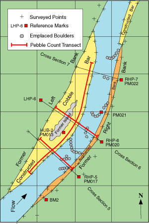
RCMAP - Example Illustration showing measurements recorded
By Colorado Water Science Center
2008 (approx.)
Detailed Description
Measurements include surveys of the channel cross section and longitudinal profile, measurement of sediment-size characteristics of the streambed and banks, and oblique photography from monumented locations through the reach.
Sources/Usage
Public Domain.
Related

Reconfigured Channel Monitoring and Assessment Program (RCMAP)
Channel reconfiguration to mitigate a variety of riverine problems has become an important issue in the Western United States. Reasons cited for channel reconfiguration include restoration to more natural or historical conditions, improved water conveyance in flood-prone areas, mitigation of unstable streambed and streambanks, increased sediment transport, and enhancement of riparian habitat or...
Related
Reconfigured Channel Monitoring and Assessment Program (RCMAP)
Channel reconfiguration to mitigate a variety of riverine problems has become an important issue in the Western United States. Reasons cited for channel reconfiguration include restoration to more natural or historical conditions, improved water conveyance in flood-prone areas, mitigation of unstable streambed and streambanks, increased sediment transport, and enhancement of riparian habitat or...