
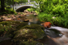
Replacement culvert for a stream crossing project on Bronson Brook in Worthington, Massachusetts
By New England Water Science Center
May 2007 (approx.)

Detailed Description
A replacement culvert for a stream crossing project on Bronson Brook at Dingle Road in Worthington, Massachusetts.
Sources/Usage
Used with permission by Paul Nguyen
Related

USGS Science Syntheses for Public Lands Management
Scientific information is fundamental to understanding how proposed actions on public lands may impact the environment. Development of new science is occurring at rates that can make it challenging for biologists, resource managers, decision makers, private landowners, and other stakeholders to ensure they are using up-to-date, high-quality science information to inform their decisions. Further...

A Statewide Hydraulic Modeling Tool for Stream Crossing Projects in Massachusetts
The U.S. Geological Survey (USGS) and the University of Massachusetts at Amherst (UMass Amherst), in cooperation with the Massachusetts Department of Environmental Protection (MassDEP), began a series of studies in 2019 to develop a GIS-based hydraulic modeling tool and to provide preliminary culvert designs for stream-crossing replacement projects in Massachusetts on USGS StreamStats.
Related
USGS Science Syntheses for Public Lands Management
Scientific information is fundamental to understanding how proposed actions on public lands may impact the environment. Development of new science is occurring at rates that can make it challenging for biologists, resource managers, decision makers, private landowners, and other stakeholders to ensure they are using up-to-date, high-quality science information to inform their decisions. Further...
A Statewide Hydraulic Modeling Tool for Stream Crossing Projects in Massachusetts
The U.S. Geological Survey (USGS) and the University of Massachusetts at Amherst (UMass Amherst), in cooperation with the Massachusetts Department of Environmental Protection (MassDEP), began a series of studies in 2019 to develop a GIS-based hydraulic modeling tool and to provide preliminary culvert designs for stream-crossing replacement projects in Massachusetts on USGS StreamStats.