
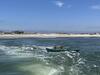
Sub-bottom surveying at Seven Mile Island, New Jersey

Detailed Description
A floating sled that enables sub‐bottom surveying in shallow water, nearshore, and shore‐face environments. The sled is equipped with an EdgeTech SB‐512i chirp system and single‐beam sonar. This equipment is used to collect seismic sub‐bottom profiles and single‐beam bathymetry. Chirp data allow them to see the sediment layers below the seafloor and understand more about the geologic history of the island. Furthermore, it allows them to understand how much mobile sediment there is offshore of the island, and how the sediment volumes vary alongshore. This information is used to evaluate how the coast has changed through time, and can be used to develop coastal planning and resilience strategies which are critical for heavily populated New Jersey coasts.
Learn more about the Coastal Sediment Availability and Flux project.
Sources/Usage
Public Domain.