
Topobathymetric elevation model of the Delaware River Basin
Detailed Description
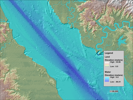
This image of the Delaware River shows how topographic (land elevation) and bathymetric (water depth) information are integrated to form a topobathymetric elevation model of the Delaware River Basin.
See the Coastal National Elevation Database (CoNED) Applications Project page for more information.
Sources/Usage
Related

Hurricane Sandy Region - Topobathymetric Elevation Model of New Jersey / Delaware
Hurricane Sandy severely impacted the New Jersey/Delaware coast, altering the topography and ecosystems of this heavily populated region. In response to the storm, the U.S. Geological Survey (USGS) Coastal and Marine Geology Program in collaboration with USGS National Geospatial Program , and National Oceanic and Atmospheric Administration developed three-dimensional (3D) topobathymetric elevation...
Related
Hurricane Sandy Region - Topobathymetric Elevation Model of New Jersey / Delaware
Hurricane Sandy severely impacted the New Jersey/Delaware coast, altering the topography and ecosystems of this heavily populated region. In response to the storm, the U.S. Geological Survey (USGS) Coastal and Marine Geology Program in collaboration with USGS National Geospatial Program , and National Oceanic and Atmospheric Administration developed three-dimensional (3D) topobathymetric elevation...