
U.S. Atlantic Margin Seeps

Detailed Description
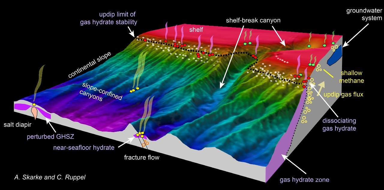
Schematic showing the general setting of seeps on the US Atlantic margin and related processes, such as gas hydrate degradation, groundwater seepage, leakage through fractured rocks, or emissions from the seafloor overlying salt diapirs. Pockmarks shown in white, and the nominal updip limit of gas hydrate stability is represented by the dashed black line. Analyses indicate that present-day seepage on this margin does not coincide with pockmarks. After the Nature Geoscience schematic.
Sources/Usage
Public Domain.
Related

Gas Hydrate and the Environment
Gas hydrate is an ice-like substance formed when methane or some other gases combine with water at appropriate pressure and temperature conditions. Nearly the entire global inventory of gas hydrates is confined to sediments in a zone tens to hundreds of meters thick close to the seafloor at water depths greater than 350–600 m. On U.S. continental marine margins alone, BOEM estimates that gas...

Gas Hydrates- Atlantic Margin Methane Seeps
Analysis of 94,000 square kilometers of multibeam water column backscatter data collected by the NOAA Okeanos Explorer mostly seaward of the shelf-break on the northern US Atlantic margin reveals more than 570 gas plumes that correspond to seafloor methane seeps. This discovery is documented in an August 2014 Nature Geoscience paper entitled, "Widespread methane leakage from the seafloor on the...
Related
Gas Hydrate and the Environment
Gas hydrate is an ice-like substance formed when methane or some other gases combine with water at appropriate pressure and temperature conditions. Nearly the entire global inventory of gas hydrates is confined to sediments in a zone tens to hundreds of meters thick close to the seafloor at water depths greater than 350–600 m. On U.S. continental marine margins alone, BOEM estimates that gas...
Gas Hydrates- Atlantic Margin Methane Seeps
Analysis of 94,000 square kilometers of multibeam water column backscatter data collected by the NOAA Okeanos Explorer mostly seaward of the shelf-break on the northern US Atlantic margin reveals more than 570 gas plumes that correspond to seafloor methane seeps. This discovery is documented in an August 2014 Nature Geoscience paper entitled, "Widespread methane leakage from the seafloor on the...