
USGS Testing ground-penetrating radar (GPR) on a cableway

Detailed Description
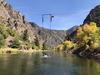
In September 2020 USGS tested ground-penetrating radar (GPR) mounted on a cableway over the Gunnison River in Colorado. USGS has been testing use of the GPR to map river bathymetry (profiles of water depth along the river), measurements often made by personnel in the water or on boats. We are also testing use of the GPR to map the shallow subsurface geology below the stream. The data also can be used to help us better understand movement of water between the ground and the stream, which is important for understanding groundwater/surface-water interactions that can affect water quality and availability. Stream bathymetry data can also be used with stream velocity measurements to estimate stream discharge at a location.
Sources/Usage
Public Domain.