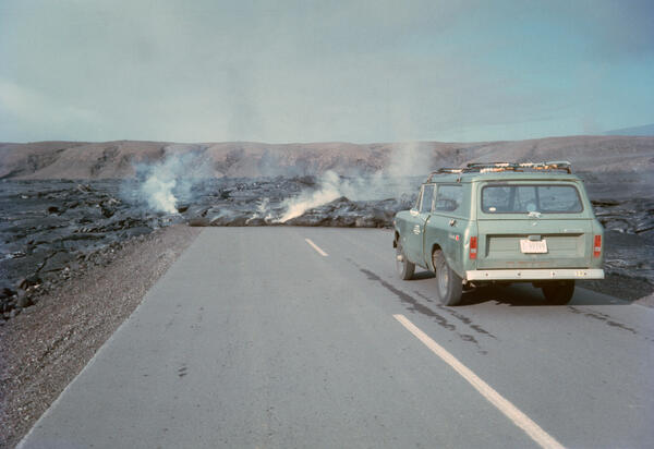
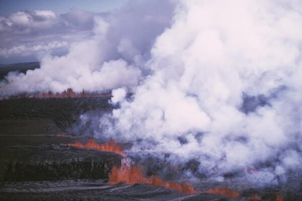
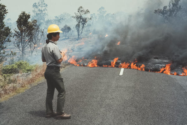
U.S. flag

An official website of the United States government

Images

Images related to natural hazards.

Filter Total Items: 7268
Three Fingered Jack (2390 m or 7840 ft) is a volcanic peak in centr...

Three Fingered Jack (2390 m or 7840 ft) is a volcanic peak in central Oregon near Mount Bachelor and the Three Sisters.

May 1973 Eruption near Hiʻiaka Crater

The May 1973 eruption near Hiʻiaka Crater was a vigorous event on Kīlauea’s upper East Rift Zone. Lasting about seven hours, it produced lava flows that traveled from just west of Hiʻiaka to Pauahi Crater, crossing what is now Chain of Craters Road in Hawaiʻi Volcanoes National Park.

The May 1973 eruption near Hiʻiaka Crater was a vigorous event on Kīlauea’s upper East Rift Zone. Lasting about seven hours, it produced lava flows that traveled from just west of Hiʻiaka to Pauahi Crater, crossing what is now Chain of Craters Road in Hawaiʻi Volcanoes National Park.

Perched lava lake above former ‘Alae Crater, September 8, 1972. Sum...
Perched lava lake above former ‘Alae Crater, Sep. 8, 1972. Summit o...

Perched lava lake above former ‘Alae Crater, September 8, 1972. Summit of Mauna Ulu shield fumes west of ‘Alae, and wooded Pu‘u Huluhulu looms in background.

Lava pours into deep pit of Makaopuhi Crater from a fissure system ...

Lava pours into deep west pit of Makaopuhi Crater from a fissure system cutting the floor of the larger east crater. August 9, 1972. Lava fed by flows from 'Alae repeatedly cascaded 200 m (650 ft) into the deep pit of Makaopuhi Crater, 1.1 km (0.7 mi) from 'Alae, in 1972, nearly filling it by August.

Lava pours into deep west pit of Makaopuhi Crater from a fissure system cutting the floor of the larger east crater. August 9, 1972. Lava fed by flows from 'Alae repeatedly cascaded 200 m (650 ft) into the deep pit of Makaopuhi Crater, 1.1 km (0.7 mi) from 'Alae, in 1972, nearly filling it by August.

Spattering in Mauna Ulu crater and at vent B along the trench Febru...
Spattering in Mauna Ulu crater and vent B along trench Feb. 28, 1973

Spattering in Mauna Ulu crater and at vent B along the trench February 28, 1972. 'Alae is the large dark oval area southeast (right) of vent B. This is the first major spattering to have occurred in the trench during the eruption. At times vent B supplied lava that moved westward in the trench and spilled into Mauna Ulu crater.

Spattering in Mauna Ulu crater and at vent B along the trench February 28, 1972. 'Alae is the large dark oval area southeast (right) of vent B. This is the first major spattering to have occurred in the trench during the eruption. At times vent B supplied lava that moved westward in the trench and spilled into Mauna Ulu crater.

Lava flowing from the summit crater of Mauna Ulu eastward into a po...

This was only about 4 days after eruptive activity resumed at Mauna Ulu after temporarily ending on October 15, 1971. Lava flowed down the trench and reoccupied the lava tube into 'Alae.

East end of summit crater of Mauna Ulu, from north rim of crater, S...

The puddle was all that remained of the lava lake in the crater, and it had disappeared by October 15, when the eruption temporarily paused.

Kīlauea's 1971 Southwest Rift Zone Eruption: A First in 52 Years...
Kīlauea's 1971 Southwest Rift Zone Eruption: A First in 52 Years

As erupting fissures migrated down Kīlauea's southwest rift zone in September 1971 for the first time in 52 years, many spectators hiked into the Ka‘ū Desert for a closer view of the rare event. Hawai‘i Volcanoes National Park rangers patrolled the area on horseback to keep people a safe distance from the lava fountains. Photo courtesy of NPS.

As erupting fissures migrated down Kīlauea's southwest rift zone in September 1971 for the first time in 52 years, many spectators hiked into the Ka‘ū Desert for a closer view of the rare event. Hawai‘i Volcanoes National Park rangers patrolled the area on horseback to keep people a safe distance from the lava fountains. Photo courtesy of NPS.

South flank of Kīlauea Volcano consists of several large scarps for...
South flank of Kīlauea consists of several large scarps formed by r...

Seaward sliding of Kīlauea's south flank over many thousands of years has resulted in large ground displacements along shallow faults that break the surface, as shown by the cliffs ("pali" in Hawaiian) seen here. Most of the movement along the faults occur during sudden slip that cause large earthquakes.

Seaward sliding of Kīlauea's south flank over many thousands of years has resulted in large ground displacements along shallow faults that break the surface, as shown by the cliffs ("pali" in Hawaiian) seen here. Most of the movement along the faults occur during sudden slip that cause large earthquakes.

Mauna Ulu trench, with crater in background. Looking west, May 25, ...
Mauna Ulu trench, w/crater in background. Looking west, May 25, 1972

Mauna Ulu trench, with crater in background. Looking west, May 25, 1971. The trench developed by collapse along the lava tube between Mauna Ulu and 'Alae, but the process was very complicated. It was separated from the summit crater by a partition of rubble.

Mauna Ulu trench, with crater in background. Looking west, May 25, 1971. The trench developed by collapse along the lava tube between Mauna Ulu and 'Alae, but the process was very complicated. It was separated from the summit crater by a partition of rubble.

Littoral explosion formed by lava entering the ocean from Mauna Ulu...

Littoral explosion formed by lava entering the ocean from Mauna Ulu through 'Alae Crater, April 12, 1971. Water was briefly trapped below lava, flashed to steam, and powered the explosion.

Skylight in lava tube carrying lava from ‘Alae crater onto to Kīlau...

Skylight in lava tube carrying lava from ‘Alae crater onto to Kīlauea's south flank, October 21, 1970. For much of 1970 and into 1971, lava flowed through a tube from Mauna Ulu into a complex lava lake in 'Alae Crater. The lake built natural levees, which allowed lake level to rise much higher than the old crater rim.

Skylight in lava tube carrying lava from ‘Alae crater onto to Kīlauea's south flank, October 21, 1970. For much of 1970 and into 1971, lava flowed through a tube from Mauna Ulu into a complex lava lake in 'Alae Crater. The lake built natural levees, which allowed lake level to rise much higher than the old crater rim.

Two unusually large driblet spires (hornitos) in ‘Ālo‘i Crater on M...
Two unusually large driblet spires in ‘Ālo‘i Crater on May 21, 1971

These spires developed on the surface of the lava fill in the crater. Since there was a fissure active in the crater on April 9, 1970, it is uncertain if these spires were true hornitos or were fed from the fissure.

These spires developed on the surface of the lava fill in the crater. Since there was a fissure active in the crater on April 9, 1970, it is uncertain if these spires were true hornitos or were fed from the fissure.

A burping driblet spire (hornito) in 'Alae Crater on May 20, 1970....
A burping driblet spire (hornito) in 'Alae Crater on May 20, 1970.

A burping driblet spire (hornito) in 'Alae Crater on May 20, 1970. In volcanology, a hornito is a rootless vent developed on, and fed by, a lava flow or lake. There was no recognized deeper vent in 'Alae Crater, so this feature is probably a real hornito.

A burping driblet spire (hornito) in 'Alae Crater on May 20, 1970. In volcanology, a hornito is a rootless vent developed on, and fed by, a lava flow or lake. There was no recognized deeper vent in 'Alae Crater, so this feature is probably a real hornito.

The only surviving segment of the fissure system active on the firs...
Only segment of fissure system active on first day of eruption

The only surviving segment of the fissure system active on the first day of the eruption. View looks west and shows the fissure segments, stepping right, and spatter rampart along right (uphill) side of the segments. No spatter rampart formed on the downhill (left) side of the segments, because falling spatter was carried away by lava flows.

The only surviving segment of the fissure system active on the first day of the eruption. View looks west and shows the fissure segments, stepping right, and spatter rampart along right (uphill) side of the segments. No spatter rampart formed on the downhill (left) side of the segments, because falling spatter was carried away by lava flows.

Color photograph of lava fountain with scientist in the foregroung
VO scientist measures Mauna Ulu lava fountain

 HVO scientist measures the episode 12 lava fountain height at Mauna Ulu from Puʻu Huluhulu on Dec 30, 1969. The Mauna Ulu eruption marks its 51st anniversary on May 24, 1969.

 HVO scientist measures the episode 12 lava fountain height at Mauna Ulu from Puʻu Huluhulu on Dec 30, 1969. The Mauna Ulu eruption marks its 51st anniversary on May 24, 1969.

Tilted slabs of welded spatter blanketed by pumice and spatter erup...

Tilted slabs of welded spatter blanketed by pumice and spatter erupted on October 20 and, mainly December 30, 1969. Note the contrast between the chaotic terrain in the foreground and the undisturbed bedding in tephra in background. The chaotic area formed as moving lava upended the tephra beds. Photo taken in March 1970.

Tilted slabs of welded spatter blanketed by pumice and spatter erupted on October 20 and, mainly December 30, 1969. Note the contrast between the chaotic terrain in the foreground and the undisturbed bedding in tephra in background. The chaotic area formed as moving lava upended the tephra beds. Photo taken in March 1970.

Fallout on flank of Pu'u Huluhulu from inclined fountain of October...
Fallout on flank of Pu'u Huluhulu from inclined fountain Oct. 20, 1970

Fallout on flank of Pu'u Huluhulu from inclined fountain of October 20, 1969. The high vertical fountain was briefly diverted toward Pu'u Huluhulu when a blockage developed at the vent. Observers at the viewing platform (on the left-most peak on the skyline) scrambled to escape, but after several minutes the fountain righted itself.

Fallout on flank of Pu'u Huluhulu from inclined fountain of October 20, 1969. The high vertical fountain was briefly diverted toward Pu'u Huluhulu when a blockage developed at the vent. Observers at the viewing platform (on the left-most peak on the skyline) scrambled to escape, but after several minutes the fountain righted itself.

Lava fountain of October 20, 1969 with viewing platform on top of P...
Lava fountain of Oct. 20, 1970

Lava fountain of October 20, 1969 with viewing platform on top of Pu'u Huluhulu. The viewing platform has a stone wall facing the fountain; it can be reached by a national park trail. The platform was occupied by HVO geologists during fountaining episodes, from which the height of the fountains was measured and photos and movies taken.

Lava fountain of October 20, 1969 with viewing platform on top of Pu'u Huluhulu. The viewing platform has a stone wall facing the fountain; it can be reached by a national park trail. The platform was occupied by HVO geologists during fountaining episodes, from which the height of the fountains was measured and photos and movies taken.

Was this page helpful?