
Acoustic doppler used to record measurements on Wild Rice River during 2010 flood. Photo taken from bridge at 174th Ave and 124th St southwest of Horace, ND.
Images
Images related to natural hazards.
Filter Total Items: 7275

Floodwater at Wild Rice River
Acoustic doppler used to record measurements on Wild Rice River during 2010 flood. Photo taken from bridge at 174th Ave and 124th St southwest of Horace, ND.

House and Car Destroyed by Tsunami
A house and a car were destroyed by a tsunami in the coastal city of Dichato, Chile, located about 15 km north of Concepcion, Chile. The tsunami height was about 10 meters (32 feet). Several hundred homes were destroyed in this city as a result of the M 8.8 earthquake on Feb. 27, 2010
A house and a car were destroyed by a tsunami in the coastal city of Dichato, Chile, located about 15 km north of Concepcion, Chile. The tsunami height was about 10 meters (32 feet). Several hundred homes were destroyed in this city as a result of the M 8.8 earthquake on Feb. 27, 2010

Floodwater at Wild Rice River
Acoustic doppler used to record measurements on Wild Rice River during 2010 flood. Photo taken from bridge at 174th Ave and 124th St southwest of Horace, ND.
Acoustic doppler used to record measurements on Wild Rice River during 2010 flood. Photo taken from bridge at 174th Ave and 124th St southwest of Horace, ND.

Port-au-Prince After the Earthquake
High resolution satellite imagery showed the landscape and building damages before and after the magnitude-7 earthquake hit Haiti in the beginning of 2010. This image was taken after the earthquake.
High resolution satellite imagery showed the landscape and building damages before and after the magnitude-7 earthquake hit Haiti in the beginning of 2010. This image was taken after the earthquake.
Coastal Landslide Caused by the 2010 Haiti Earthquake
Coastal Landslide Caused by the 2010 Haiti EarthquakeEarthquake-triggered landslide on south coast of Haiti near village of Nan Diamant.
Coastal Landslide Caused by the 2010 Haiti Earthquake
Coastal Landslide Caused by the 2010 Haiti EarthquakeEarthquake-triggered landslide on south coast of Haiti near village of Nan Diamant.

LP Field, 2010
Rivers in middle Tennessee crested May 2-3,2010, breaking records at many USGS-operated streamgages. The flood peak on the Cumberland River in downtown Nashville ranks as the highest observed during the past 73 years.
Rivers in middle Tennessee crested May 2-3,2010, breaking records at many USGS-operated streamgages. The flood peak on the Cumberland River in downtown Nashville ranks as the highest observed during the past 73 years.

USGS Measures Flooding in Louisiana
USGS scientists Paul Frederick and Mike Descant make sure there is enough clearance for their boat to drive under a bridge on the Atchafalaya River near Melville, La.
USGS scientists Paul Frederick and Mike Descant make sure there is enough clearance for their boat to drive under a bridge on the Atchafalaya River near Melville, La.

Road Damage from 2008 Great Sichuan Earthquake in China
Road Damage from 2008 Great Sichuan Earthquake in ChinaThe May 12, 2008, Great Sichuan Earthquake, also called the Wenchuan Earthquake, occurred at 14:28 local time, in Sichuan Province, China. The earthquake magnitudes were Mw = 7.9 (USGS), Ms = 8.0 (Chinese Earthquake Administration). The epicenter was 80 km west-northwest of Chengdu, the capital city of Sichuan province.

House Damage from 2011 Central Virginia Earthquake
House Damage from 2011 Central Virginia EarthquakeChimney damage to a house in Louisa County, Virginia, after a magnitude 5.8 earthquake on August 23, 2011.
House Damage from 2011 Central Virginia Earthquake
House Damage from 2011 Central Virginia EarthquakeChimney damage to a house in Louisa County, Virginia, after a magnitude 5.8 earthquake on August 23, 2011.

Mameyes River Flood
The Mameyes River in flood. Eastern Puerto Rico.
The Mameyes River in flood. Eastern Puerto Rico.

Aerial Oblique Photography Comparing the Chandeleur Islands Before and After Hurricane Isaac
Aerial Oblique Photography Comparing the Chandeleur Islands Before and After Hurricane IsaacThe images reveal significant erosion of the island, likely due to inundation by waves and surge.This erosion resulted in the disappearance of an oil-protection berm constructed follow the BP oil spill. Due to this island's cumulative damage from previous storms like Hurricane Katrina, it remains in question whether this beach system will ever be able to fully

Forest Die-Off in Southwest: 2002 and 2004
These photos show the kind of massive forest die-off that is projected to occur more frequently in the Southwest. Piñon pines, normally evergreen, have reddish-brown foliage in October 2002 (left). By May 2004 (right), the dead piñon pines have lost all their needles, exposing gray trunks and branches.
These photos show the kind of massive forest die-off that is projected to occur more frequently in the Southwest. Piñon pines, normally evergreen, have reddish-brown foliage in October 2002 (left). By May 2004 (right), the dead piñon pines have lost all their needles, exposing gray trunks and branches.
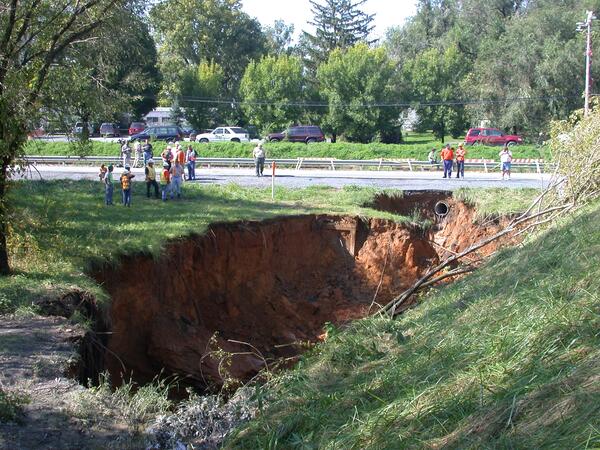
Sinkhole in Frederick, Maryland
Cover-collapse sinkhole in limestone near Frederick, Maryland (September 2003). Many sinkholes occur along highways where rainwater runoff is concentrated into storm drains and ditches increasing the rate of sinkhole development (note the sewer drain pipe beneath roadway).
Cover-collapse sinkhole in limestone near Frederick, Maryland (September 2003). Many sinkholes occur along highways where rainwater runoff is concentrated into storm drains and ditches increasing the rate of sinkhole development (note the sewer drain pipe beneath roadway).

Mw6.6 Lushan China Earthquake, April 20 2013
Damage to a village house. Longxingcun.

Mw6.6 Lushan China Earthquake, April 20 2013
Building damage inside Lushan station.

Earthquake and Landslides in the Union of the Comoros
Earthquake and Landslides in the Union of the ComorosHeavy rains from a tropical cyclone struck the islands of the Comoros in March, 2014. On the island of Anjouan in the Union of Comoros, these rains triggered landslides that displaced over 3000 people to refugee camps.

Earthquake and Landslides in the Union of the Comoros
Earthquake and Landslides in the Union of the ComorosHeavy rains from a tropical cyclone struck the islands of the Comoros in March, 2014. On the island of Anjouan in the Union of Comoros, these rains triggered landslides that displaced over 3000 people to refugee camps. The USGS and the OFDA with USAID are providing support and research assistance on these events.

Earthquake and Landslides in the Union of the Comoros
Earthquake and Landslides in the Union of the ComorosHeavy rains from a tropical cyclone struck the islands of the Comoros in March, 2014. On the island of Anjouan in the Union of Comoros, these rains triggered landslides that displaced over 3000 people to refugee camps.

Shipwreck in Palmyra Atoll
Shipwrecks and other artificial structures increase the potential for large invasions of unwanted species into coral reefs, even relatively pristine ones. In this picture, a shipwreck in the remote Palmyra Atoll in the central Pacific Ocean resulted in the dense colonization of an invasive coral-like species called Rhodactis howesii, pictured here.
Shipwrecks and other artificial structures increase the potential for large invasions of unwanted species into coral reefs, even relatively pristine ones. In this picture, a shipwreck in the remote Palmyra Atoll in the central Pacific Ocean resulted in the dense colonization of an invasive coral-like species called Rhodactis howesii, pictured here.

Sand Dune
Sand Dune Cape Henlopen, Delaware.
Sand Dune Cape Henlopen, Delaware.

Floodwater at Wild Rice River
USGS personnel at work using acoustic doppler on bridge over Wild Rice River. Photo taken at 174th Ave and 124th St southwest of Horace, ND.
USGS personnel at work using acoustic doppler on bridge over Wild Rice River. Photo taken at 174th Ave and 124th St southwest of Horace, ND.