
Many large blocks appeared to be in depressions in the ash, but upon closer examination, it was concluded that wind had winnowed ash from around the blocks, creating a false impression that the depressions were made by impact.
Images
Images related to natural hazards.
Filter Total Items: 7275

Kīlauea Volcano — Large Rocks on Parking Lot
Many large blocks appeared to be in depressions in the ash, but upon closer examination, it was concluded that wind had winnowed ash from around the blocks, creating a false impression that the depressions were made by impact.
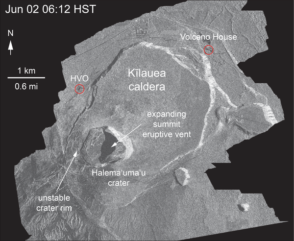
Satellite radar shows continued inward slumping of Halema‘uma‘u
Satellite radar shows continued inward slumping of Halema‘uma‘uThis animated GIF shows a sequence of radar amplitude images that were acquired by the Italian Space Agency's Cosmo-SkyMed satellite system. The images illustrate changes to the caldera area of Kīlauea Volcano that occurred between May 5 and June 6 at 6:00 a.m. HST.

Kīlauea Volcano — Crack on Crater Rim Drive
Crack on Crater Rim Drive just east of the parking lot, with the National Park sign indicating "Halema‘uma‘u" at right. This crack shows 42 cm (16.5 in) of right lateral offset—as measured by fitting the center stripe on the road back together)—and was about 25 cm (10 in) wide.
Crack on Crater Rim Drive just east of the parking lot, with the National Park sign indicating "Halema‘uma‘u" at right. This crack shows 42 cm (16.5 in) of right lateral offset—as measured by fitting the center stripe on the road back together)—and was about 25 cm (10 in) wide.

Kīlauea Volcano — Ballistic Blocks
With careful consideration and planning to avoid ongoing volcanic hazards as much as possible, an HVO scientist who has been studying the behavior of Kīlauea's summit for decades, briefly visited the parking area for the former Halema‘uma‘u overlook (closed since 2008) on June 5 to make direct observations of and gather data from the effects of recent explosions wit
With careful consideration and planning to avoid ongoing volcanic hazards as much as possible, an HVO scientist who has been studying the behavior of Kīlauea's summit for decades, briefly visited the parking area for the former Halema‘uma‘u overlook (closed since 2008) on June 5 to make direct observations of and gather data from the effects of recent explosions wit

Kīlauea Volcano — Halema`uma`u Parking Lot
The Halema‘uma‘u parking lot is sliced into blocks by cracks. These cracks, first noted in a very early stage on May 13, now are the dominant features of the parking lot. The cracks, which are circumferential to Halema‘uma‘u, warp and offset the pavement and curbing, as seen here. The crack responsible for warping this curbstone is visible on both sides of it.
The Halema‘uma‘u parking lot is sliced into blocks by cracks. These cracks, first noted in a very early stage on May 13, now are the dominant features of the parking lot. The cracks, which are circumferential to Halema‘uma‘u, warp and offset the pavement and curbing, as seen here. The crack responsible for warping this curbstone is visible on both sides of it.

An even larger crack, shown here, arcs across the parking lot and b...
An even larger crack, shown here, arcs across the parking lot and b...An even larger crack, shown here, arcs across the parking lot and bounds one of the large blocks mentioned above.
An even larger crack, shown here, arcs across the parking lot and b...
An even larger crack, shown here, arcs across the parking lot and b...An even larger crack, shown here, arcs across the parking lot and bounds one of the large blocks mentioned above.

Another explosion at the summit of Kīlauea
On June 6, at 4:07 p.m. HST, an explosion within Halema‘uma‘u sent an ash and gas plume to a height of about 10,000 feet above sea level. The explosion released energy equivalent to that of a magnitude-5.6 earthquake; a result of the explosion-related energy release was ground shaking felt throughout the summit area.
On June 6, at 4:07 p.m. HST, an explosion within Halema‘uma‘u sent an ash and gas plume to a height of about 10,000 feet above sea level. The explosion released energy equivalent to that of a magnitude-5.6 earthquake; a result of the explosion-related energy release was ground shaking felt throughout the summit area.

Kīlauea Volcano — Satellite Imagery Fissure 8
The International Charter for Space and Major Disasters (https://disasterscharter.org/) is a means for space agencies around the world to help with disaster monitoring by providing satellite data to responders and scientists on the ground.
The International Charter for Space and Major Disasters (https://disasterscharter.org/) is a means for space agencies around the world to help with disaster monitoring by providing satellite data to responders and scientists on the ground.

Kīlauea Volcano — Halema`uma`u Explosion (June 6)

Kīlauea Volcano — Lava Fountaining (Fissure 8)
The vigorous lava fountain at Fissure 8 reached heights of 45 m (150 ft) as shown in this image taken around 9:30 AM.
The vigorous lava fountain at Fissure 8 reached heights of 45 m (150 ft) as shown in this image taken around 9:30 AM.

Kīlauea Volcano — Lower East Rift Zone
This view, looking south at Kīlauea's lower East Rift Zone, was captured during HVO's 6:00 a.m. HST helicopter overflight today.
This view, looking south at Kīlauea's lower East Rift Zone, was captured during HVO's 6:00 a.m. HST helicopter overflight today.

Kīlauea Volcano — Lava Delta at Kapoho Bay
This fish-eye view of the lava delta filling the former Kapoho Bay shows that while the delta margin nearest the ocean has cooled somewhat, the lava flow front is still very hot and producing laze (lava haze). Laze is a local hazard composed of acidic gases and volcanic glass fragments and should be avoided.
This fish-eye view of the lava delta filling the former Kapoho Bay shows that while the delta margin nearest the ocean has cooled somewhat, the lava flow front is still very hot and producing laze (lava haze). Laze is a local hazard composed of acidic gases and volcanic glass fragments and should be avoided.


Robust fissure 8 lava channels and ocean entry plume
Robust fissure 8 lava channels and ocean entry plumeThis view, looking south at Kīlauea's lower East Rift Zone, was captured during HVO's 6:00 a.m. HST helicopter overflight today. It shows continued fountaining of fissure 8 and the lava flow channel fed by it. Lava continues to flow quickly in these braided channels; the flow margins are currently stable and have not experienced any breakouts since June 5.

Kīlauea LERZ lava flows and fissures, June 6, 12:00 p.m.
Kīlauea LERZ lava flows and fissures, June 6, 12:00 p.m.Map as of 12:00 p.m. (noon) HST, June 6, 2018. Given the dynamic nature of Kīlauea's lower East Rift Zone eruption, with changing vent locations, fissures starting and stopping, and varying rates of lava effusion, map details shown here are accurate as of the date/time noted. Shaded purple areas indicate lava flows erupted in 1840, 1955, 1960, and 2014-2015.

Thermal map of fissure system and lava flows
This thermal map shows the fissure system and lava flows as of 12:30 pm on Wednesday, June 6. The flow from Fissure 8 remains active, with the flow front entering the ocean at Kapoho. The black and white area is the extent of the thermal map.
This thermal map shows the fissure system and lava flows as of 12:30 pm on Wednesday, June 6. The flow from Fissure 8 remains active, with the flow front entering the ocean at Kapoho. The black and white area is the extent of the thermal map.

Kīlauea Volcano — Kapoho Beach Lots
Views from HVO's helicopter overflight at 1PM HST, show the remains of the Kapoho Beach Lots subdivision and the fissure 8 flow front. The northern flow margin in this area was unchanged from HVO's morning flight and appeared to have stopped advancing at the time of the flight.
Views from HVO's helicopter overflight at 1PM HST, show the remains of the Kapoho Beach Lots subdivision and the fissure 8 flow front. The northern flow margin in this area was unchanged from HVO's morning flight and appeared to have stopped advancing at the time of the flight.

Morning view of Halema'uma'u crater on June 6
Morning view of Halema'uma'u and the Kīlauea Caldera from the Kīlauea overlook. Heavy steam dominates the view, and strong winds are blowing the plume to the southwest.
Morning view of Halema'uma'u and the Kīlauea Caldera from the Kīlauea overlook. Heavy steam dominates the view, and strong winds are blowing the plume to the southwest.

Kīlauea Volcano — Lava Fountaining
Lava fountaining continues at fissure 8, although overnight crews reported reduced heights of 40-50 m (130-164 ft). The fountain has built a 35 m (115 ft) high cone, and an actively-growing spatter rampart on its eastern side.
Lava fountaining continues at fissure 8, although overnight crews reported reduced heights of 40-50 m (130-164 ft). The fountain has built a 35 m (115 ft) high cone, and an actively-growing spatter rampart on its eastern side.

Kīlauea Volcano — Halema‘uma‘u Crater Aerial
HVO scientists captured this aerial view of a much-changed Halema‘uma‘u during their overflight of the summit this afternoon.
HVO scientists captured this aerial view of a much-changed Halema‘uma‘u during their overflight of the summit this afternoon.

Kīlauea Volcano — Kapoho Bay Filled with Lava
As of the morning of June 5, the fissure 8 lava flow front had completely filled Kapoho Bay.
As of the morning of June 5, the fissure 8 lava flow front had completely filled Kapoho Bay.