
The USGS groundwater Climate Response Network is a national network of wells selected to monitor natural groundwater-level conditions in unconfined or near-surface confined aquifers that are minimally affected by pumping or other human-induced stresses.

The Climate Response Network (CRN) provides the timely water-level data needed to understand natural groundwater conditions throughout the United States, Puerto Rico, and the U.S. Virgin Islands. These long-term records provide a statistical framework for evaluating trends in our Nation’s groundwater resources, enable improved drought management, and serve as the basis for assessments and models that characterize the connections between long-term atmospheric conditions and groundwater levels.
The CRN is designed to help answer two important questions:
- What are the current conditions of our Nation’s groundwater levels (depth to water below land surface)?
- How are long-term atmospheric conditions affecting our Nation’s groundwater levels?
Building on Decades of Monitoring
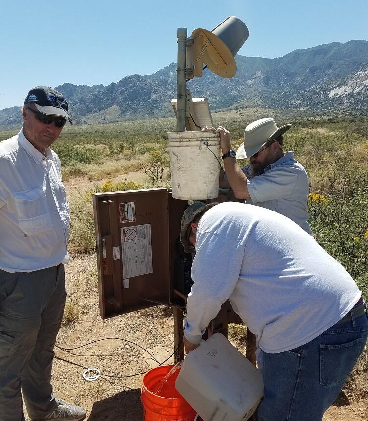
Water-level measurements from observation wells are the primary source of information about the effects of hydrologic stresses on groundwater systems. The USGS uses consistent water-level data-collection techniques and quality-control methods. Discrete water-level measurements are collected using graduated steel and electric tapes. Continuous water levels are collected using pressure transducers and floats at more than 2,000 groundwater sites nationwide, and are transmitted via satellite, telephone, and/or radio telemetry and made available in near real time through the National Water Information System. A subset of these wells are included in the CRN.
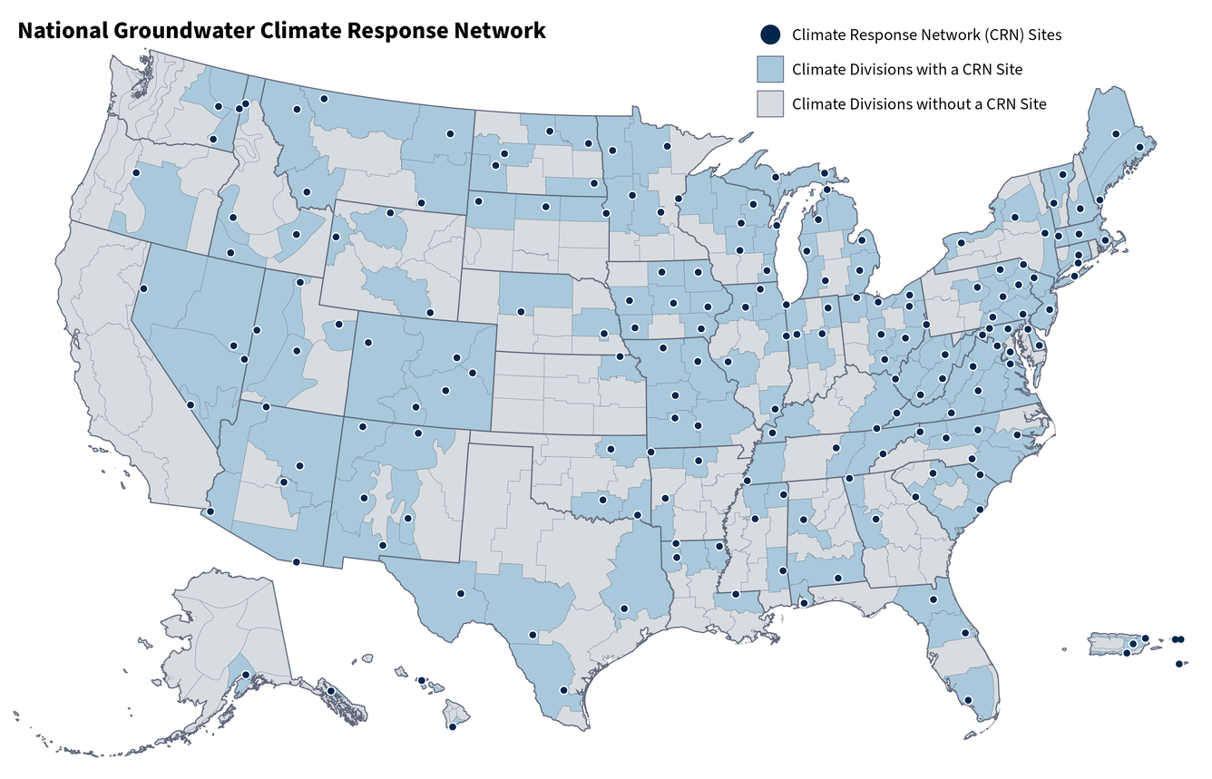
The CRN network is designed is to have at least one monitored site within each of the Nation’s 366 climate divisions in the United States, Puerto Rico, and the Virgin Islands. In 2006, the CRN operated approximately 140 federally funded wells. At its peak (2021–23), the CRN included federally funded data collection at 256 sites representing nearly 70 percent of the Nation’s climate divisions.
The Climate Response Network
In 2025, the USGS monitored 186 federally funded wells located within about 51 percent of the Nation’s climate divisions across the United States and its territories as part of the CRN. The CRN also includes over 400 supplemental sites located mostly in the eastern United States monitored in cooperation with State, Local, Regional, Tribal, or other Federal partners.
- Federally-funded sites: These sites are authorized by the SECURE Water Act of 2009 (U.S. Congress, 2009) through the USGS Groundwater and Streamflow Information Program. Groundwater levels are continuously measured at 15- to 60-minute intervals with automatic water-level sensors and regularly transmit data to USGS databases every 1 to 4 hours.
- Supplemental sites: These sites are monitored in cooperation with State, Local, Regional, Tribal, or other Federal partners. The frequency of groundwater-level measurements ranges from periodic (monthly to quarterly) manual measurements to continuous (15- to 60-minute intervals) measurements collected with automatic sensing devices. Pending the frequency of field visits, the availability of these data may lag current conditions by several months.

The current list of CRN sites is available at the Groundwater Climate Response Network Mapper.
Criteria for Climate Response Network Sites
Typically, observation wells tend to be concentrated in areas where aquifers are heavily developed. In contrast, the CRN sites are intentionally located away from the influence of water-supply pumping, irrigation, and other human activities to allow for monitoring of the natural effects of climate variability.
Additionally, the following are the criteria for inclusion in the CRN:
- Open to a single, known hydrogeologic unit
- Known well construction that allows good water-level measurements
- Located in unconfined aquifers or near-surface confined aquifers that respond to climatic fluctuations
- Minimally affected by pumpage and likely to remain so
- Essentially unaffected by irrigation, canals, and other potential sources of artificial recharge
- Long-term accessibility
- Well has never gone dry and is not susceptible to going dry
Tracking the Response of Climate Variability in Our Nation’s Groundwater Systems
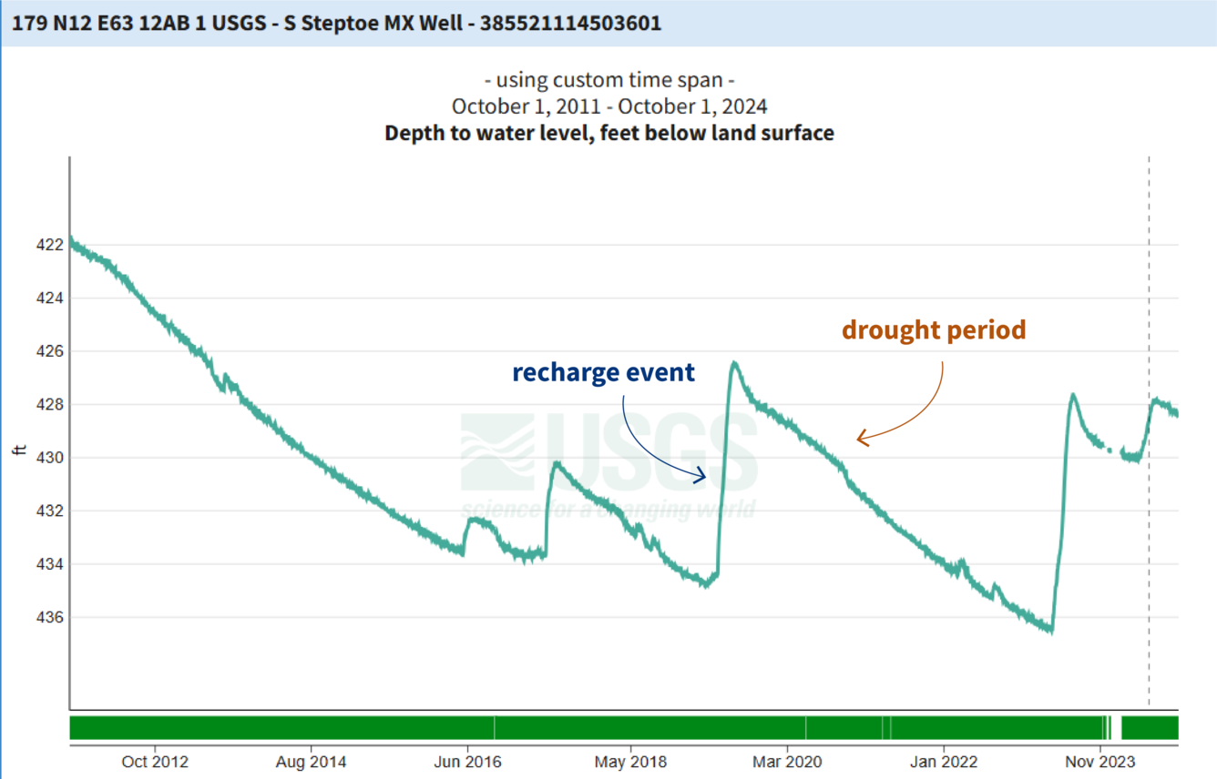
The collection of water-level data to adequately assess water-level trends, including the effects of climate variability and regional aquifer development, typically requires years or decades. Long-term datasets are necessary to provide the statistical rigor to accurately evaluate our vital ground-water resources.
Currently, the average period of record among the federally funded CRN sites is over 37 years, and 53 of the 186 sites have over 50 years of groundwater level records. The longest running CRN well is a 31-foot-deep, hand-dug well located in Oneida County, New York (USGS station 433112075091501), that has groundwater measurements from 1926 to present. CRN data are available through the Groundwater Climate Response Network Mapper.
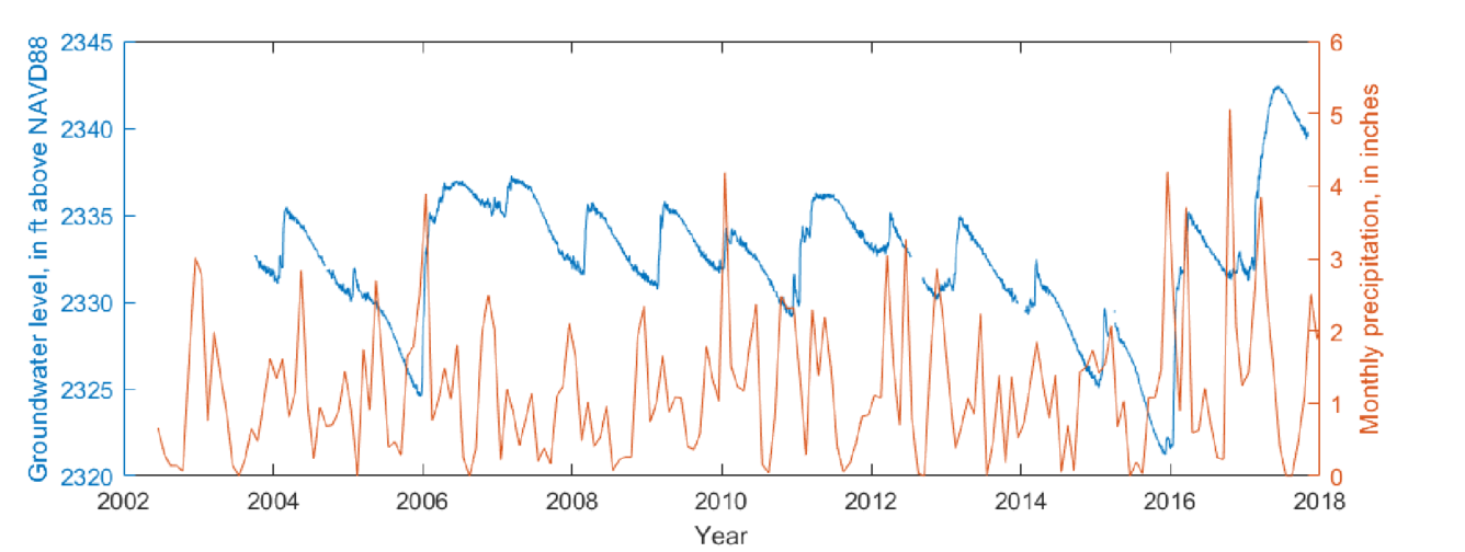
CRN data can also provide valuable information for improved resource management decisions. For example, Long and Konrad (2020) used CRN data to characterize the relationship between precipitation and responses in groundwater levels at seasonal to decadal scales. They compared seasonality characteristics of precipitation to those of groundwater at several sites and were able to model the lag time from the annual precipitation peaks to the annual groundwater peaks (the first image in the slideshow below shows a lag of 4.4 months at a CRN site in Lincoln County, Washington). The methods they developed are transferable and can be used to evaluate other groundwater-level records across the continental U.S.


Connecting the dots between USGS water monitoring networks
The CRN is the groundwater-level monitoring arm of the USGS national water monitoring “network of networks” that measures the Nation’s water resources to meet the water management and prediction needs of the Nation. Data from the CRN is also used in the USGS National Water Availability Assessment Report which provides a comprehensive, scientific summary and interpretation of water quality, quantity and water use in the United States. This effort draws upon data collected at stream sampling sites, groundwater wells, rain gages and other monitoring locations maintained by the USGS. In some cases, this information is interpreted directly in support of the National Assessment and in other cases serves as calibration data for regional and national-scale models of key hydrologic processes in the United States.
The funding for the CRN comes from the Groundwater and Streamflow Information Program (GWSIP). The USGS Water Resources Mission Area operates and coordinates large, congressionally mandated USGS water-observing networks such as the Climate Response Network.
Authorizations
USGS activities are conducted under the authority of various pieces of authorizing federal legislation. The following is a subset of authorizations that are related to the Climate Response Network and all of its sub-networks:
42 U.S.C. § 10367 - 10368 | Omnibus Public Land Management Act of 2009 (SECURE Water Act) (Pub. L. 111-11)
Authorizes (Title IX, Subtitle F, Sec. 9507 and 9508) the implementation of the national streamflow information program (more than 4,700 federal priority streamgages), development of a systematic groundwater monitoring program for each major aquifer system (the National Groundwater Monitoring Network), completion of a national brackish groundwater assessment, and implementation of the national water availability and use assessment program.
Title IX, Subtitle F, Sec. 9507 authorizes the completion of a national brackish groundwater assessment (2011). [Areas: Water Resources, Drought, Flooding] [Interagency Support: State and Local Governments
Title IX, Subtitle F, Sec 9508 authorizes the implementation of the national water availability and use assessment program.
Title IX, Subtitle F, Sec. 9508 authorizes a grant program to collect and improve State water use data (2013).
Title XI, Sec. 11002 directs the USGS to conduct a study of water resources in New Mexico, specifically including the Estancia Basin, Salt Basin, Tularosa Basin, Hueco Basin, and middle Rio Grande Basin.

National Water Monitoring Network
The USGS groundwater Climate Response Network is a national network of wells selected to monitor natural groundwater-level conditions in unconfined or near-surface confined aquifers that are minimally affected by pumping or other human-induced stresses.
The Climate Response Network (CRN) provides the timely water-level data needed to understand natural groundwater conditions throughout the United States, Puerto Rico, and the U.S. Virgin Islands. These long-term records provide a statistical framework for evaluating trends in our Nation’s groundwater resources, enable improved drought management, and serve as the basis for assessments and models that characterize the connections between long-term atmospheric conditions and groundwater levels.
The CRN is designed to help answer two important questions:
- What are the current conditions of our Nation’s groundwater levels (depth to water below land surface)?
- How are long-term atmospheric conditions affecting our Nation’s groundwater levels?
Building on Decades of Monitoring
Water-level measurements from observation wells are the primary source of information about the effects of hydrologic stresses on groundwater systems. The USGS uses consistent water-level data-collection techniques and quality-control methods. Discrete water-level measurements are collected using graduated steel and electric tapes. Continuous water levels are collected using pressure transducers and floats at more than 2,000 groundwater sites nationwide, and are transmitted via satellite, telephone, and/or radio telemetry and made available in near real time through the National Water Information System. A subset of these wells are included in the CRN.
The CRN network is designed is to have at least one monitored site within each of the Nation’s 366 climate divisions in the United States, Puerto Rico, and the Virgin Islands. In 2006, the CRN operated approximately 140 federally funded wells. At its peak (2021–23), the CRN included federally funded data collection at 256 sites representing nearly 70 percent of the Nation’s climate divisions.
The Climate Response Network
In 2025, the USGS monitored 186 federally funded wells located within about 51 percent of the Nation’s climate divisions across the United States and its territories as part of the CRN. The CRN also includes over 400 supplemental sites located mostly in the eastern United States monitored in cooperation with State, Local, Regional, Tribal, or other Federal partners.
- Federally-funded sites: These sites are authorized by the SECURE Water Act of 2009 (U.S. Congress, 2009) through the USGS Groundwater and Streamflow Information Program. Groundwater levels are continuously measured at 15- to 60-minute intervals with automatic water-level sensors and regularly transmit data to USGS databases every 1 to 4 hours.
- Supplemental sites: These sites are monitored in cooperation with State, Local, Regional, Tribal, or other Federal partners. The frequency of groundwater-level measurements ranges from periodic (monthly to quarterly) manual measurements to continuous (15- to 60-minute intervals) measurements collected with automatic sensing devices. Pending the frequency of field visits, the availability of these data may lag current conditions by several months.
The current list of CRN sites is available at the Groundwater Climate Response Network Mapper.
Criteria for Climate Response Network Sites
Typically, observation wells tend to be concentrated in areas where aquifers are heavily developed. In contrast, the CRN sites are intentionally located away from the influence of water-supply pumping, irrigation, and other human activities to allow for monitoring of the natural effects of climate variability.
Additionally, the following are the criteria for inclusion in the CRN:
- Open to a single, known hydrogeologic unit
- Known well construction that allows good water-level measurements
- Located in unconfined aquifers or near-surface confined aquifers that respond to climatic fluctuations
- Minimally affected by pumpage and likely to remain so
- Essentially unaffected by irrigation, canals, and other potential sources of artificial recharge
- Long-term accessibility
- Well has never gone dry and is not susceptible to going dry
Tracking the Response of Climate Variability in Our Nation’s Groundwater Systems
The collection of water-level data to adequately assess water-level trends, including the effects of climate variability and regional aquifer development, typically requires years or decades. Long-term datasets are necessary to provide the statistical rigor to accurately evaluate our vital ground-water resources.
Currently, the average period of record among the federally funded CRN sites is over 37 years, and 53 of the 186 sites have over 50 years of groundwater level records. The longest running CRN well is a 31-foot-deep, hand-dug well located in Oneida County, New York (USGS station 433112075091501), that has groundwater measurements from 1926 to present. CRN data are available through the Groundwater Climate Response Network Mapper.
CRN data can also provide valuable information for improved resource management decisions. For example, Long and Konrad (2020) used CRN data to characterize the relationship between precipitation and responses in groundwater levels at seasonal to decadal scales. They compared seasonality characteristics of precipitation to those of groundwater at several sites and were able to model the lag time from the annual precipitation peaks to the annual groundwater peaks (the first image in the slideshow below shows a lag of 4.4 months at a CRN site in Lincoln County, Washington). The methods they developed are transferable and can be used to evaluate other groundwater-level records across the continental U.S.
Connecting the dots between USGS water monitoring networks
The CRN is the groundwater-level monitoring arm of the USGS national water monitoring “network of networks” that measures the Nation’s water resources to meet the water management and prediction needs of the Nation. Data from the CRN is also used in the USGS National Water Availability Assessment Report which provides a comprehensive, scientific summary and interpretation of water quality, quantity and water use in the United States. This effort draws upon data collected at stream sampling sites, groundwater wells, rain gages and other monitoring locations maintained by the USGS. In some cases, this information is interpreted directly in support of the National Assessment and in other cases serves as calibration data for regional and national-scale models of key hydrologic processes in the United States.
The funding for the CRN comes from the Groundwater and Streamflow Information Program (GWSIP). The USGS Water Resources Mission Area operates and coordinates large, congressionally mandated USGS water-observing networks such as the Climate Response Network.
Authorizations
USGS activities are conducted under the authority of various pieces of authorizing federal legislation. The following is a subset of authorizations that are related to the Climate Response Network and all of its sub-networks:
42 U.S.C. § 10367 - 10368 | Omnibus Public Land Management Act of 2009 (SECURE Water Act) (Pub. L. 111-11)
Authorizes (Title IX, Subtitle F, Sec. 9507 and 9508) the implementation of the national streamflow information program (more than 4,700 federal priority streamgages), development of a systematic groundwater monitoring program for each major aquifer system (the National Groundwater Monitoring Network), completion of a national brackish groundwater assessment, and implementation of the national water availability and use assessment program.
Title IX, Subtitle F, Sec. 9507 authorizes the completion of a national brackish groundwater assessment (2011). [Areas: Water Resources, Drought, Flooding] [Interagency Support: State and Local Governments
Title IX, Subtitle F, Sec 9508 authorizes the implementation of the national water availability and use assessment program.
Title IX, Subtitle F, Sec. 9508 authorizes a grant program to collect and improve State water use data (2013).
Title XI, Sec. 11002 directs the USGS to conduct a study of water resources in New Mexico, specifically including the Estancia Basin, Salt Basin, Tularosa Basin, Hueco Basin, and middle Rio Grande Basin.