

Earthquakes affect Earth’s intricate plumbing system. The magnitude 9.0 earthquake in Japan on March 11, 2011 affected water levels in groundwater wells in many places in the United States. In this episode of CoreCast USGS Geophysicist Evelyn Roeloffs explains this phenomenon.
Groundwater-Level Response to Virginia Earthquake, August 23, 2011
Completed
By Water Resources Mission Area
February 23, 2019
A magnitude 5.8 (Mw) earthquake occurred at 1:51 pm EDT (17:51 UTC) on August 23, 2011, at a depth of about 3.7 miles (6 kilometers) beneath the town of Mineral, Virginia, located approximately 27 miles (45 kilometers) east of Charlottesville. The event is among the largest earthquakes recorded in the eastern United States.
Media

Sources/Usage: Public Domain. View Media Details
How do Earthquakes Affect Groundwater Levels?
Groundwater-level responses to earthquakes have been investigated for decades, and have been documented close to and far from earthquake epicenters. The most common groundwater-level response is a water-level oscillation. This occurs frequently, but often is not recorded because water-level measurements typically are not recorded frequently enough with today’s electronic instrumentation to record the water-level response. An instantaneous water-level offset, or step, is more commonly recorded. These step changes can be large enough to make a well flow at land surface, or to cause a well to go dry near an earthquake. Typically, however, the water-level changes are several feet or less. Recovery to the pre-earthquake water level can be nearly instantaneous, or it may take as long as days or months, or may not recover at all.
Groundwater-level responses most often occur as the earthquake’s seismic wave train arrives (coseismic), though responses have been observed after the wave train passes (postseismic); scientists also are investigating water-level changes observed before an earthquake (preseismic), though research is needed to explain these phenomena.
Step changes in groundwater levels occur 'near field' of an earthquake because the earthquake subjects the earth's crust, including its aquifer systems, to stress and permanent strain (deformation). This deformation process results in altered fluid pressure within the aquifer systems, and consequently, a steplike change in water level would be expected. Changes can be up or down, because the stress and strain effects on the system vary. For upward steps in shallow wells, compaction of overlying sediments may raise the groundwater level. Alternately, in a fractured rock aquifer, the fractures providing water to the well may be widened, unclogged, or sealed by the wave train of an earthquake. New water-bearing fractures may even be created. Water levels in these systems can permanently increase or decrease as a result.
Slide Show of Selected Hydrographs
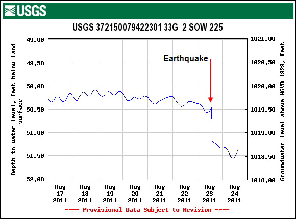
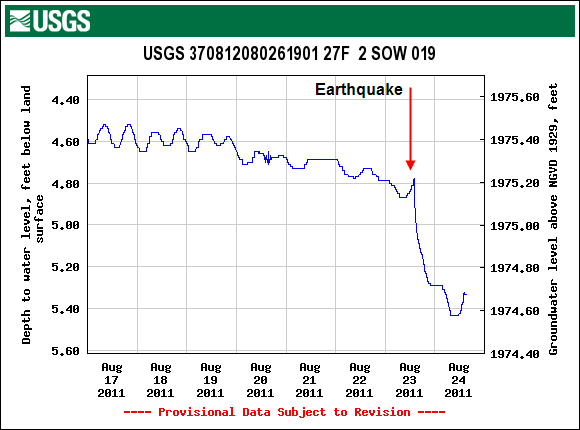
The six hydrographs below present groundwater levels measured in selected wells monitored by the USGS (all data are from Water Data for the Nation). These graphs were selected as examples of locations where measured groundwater levels responded to the August 23, 2011, Virginia earthquake. The red arrow indicates the approximate time of the mainshock of the earthquake near Mineral, Virginia.


| USGS Site Number | State | Well Depth (in feet) | Aquifer |
|---|---|---|---|
| 372322081241501 | WV | 152 | Pocahontas Formation |
| 394024078273401 | MD | 114.5 | Brallier Formation |
| 372150079422301 | VA | 201 | Piedmont and Blue Ridge crystalline-rock aquifers |
| 370812080261901 | VA | 450 | Valley and Ridge aquifers |
| 421157075535401 | NY | 252 | Sonyea Formation |
| 402411077374801 | PA | 110 | Brailler and Harrell Formations |
Other Information
Below are multimedia items associated with this project.
Waves Rippling Through Groundwater
Earthquakes affect Earth’s intricate plumbing system. The magnitude 9.0 earthquake in Japan on March 11, 2011 affected water levels in groundwater wells in many places in the United States. In this episode of CoreCast USGS Geophysicist Evelyn Roeloffs explains this phenomenon.
A magnitude 5.8 (Mw) earthquake occurred at 1:51 pm EDT (17:51 UTC) on August 23, 2011, at a depth of about 3.7 miles (6 kilometers) beneath the town of Mineral, Virginia, located approximately 27 miles (45 kilometers) east of Charlottesville. The event is among the largest earthquakes recorded in the eastern United States.
Media
Sources/Usage: Public Domain. View Media Details
How do Earthquakes Affect Groundwater Levels?
Groundwater-level responses to earthquakes have been investigated for decades, and have been documented close to and far from earthquake epicenters. The most common groundwater-level response is a water-level oscillation. This occurs frequently, but often is not recorded because water-level measurements typically are not recorded frequently enough with today’s electronic instrumentation to record the water-level response. An instantaneous water-level offset, or step, is more commonly recorded. These step changes can be large enough to make a well flow at land surface, or to cause a well to go dry near an earthquake. Typically, however, the water-level changes are several feet or less. Recovery to the pre-earthquake water level can be nearly instantaneous, or it may take as long as days or months, or may not recover at all.
Groundwater-level responses most often occur as the earthquake’s seismic wave train arrives (coseismic), though responses have been observed after the wave train passes (postseismic); scientists also are investigating water-level changes observed before an earthquake (preseismic), though research is needed to explain these phenomena.
Step changes in groundwater levels occur 'near field' of an earthquake because the earthquake subjects the earth's crust, including its aquifer systems, to stress and permanent strain (deformation). This deformation process results in altered fluid pressure within the aquifer systems, and consequently, a steplike change in water level would be expected. Changes can be up or down, because the stress and strain effects on the system vary. For upward steps in shallow wells, compaction of overlying sediments may raise the groundwater level. Alternately, in a fractured rock aquifer, the fractures providing water to the well may be widened, unclogged, or sealed by the wave train of an earthquake. New water-bearing fractures may even be created. Water levels in these systems can permanently increase or decrease as a result.
Slide Show of Selected Hydrographs
The six hydrographs below present groundwater levels measured in selected wells monitored by the USGS (all data are from Water Data for the Nation). These graphs were selected as examples of locations where measured groundwater levels responded to the August 23, 2011, Virginia earthquake. The red arrow indicates the approximate time of the mainshock of the earthquake near Mineral, Virginia.
| USGS Site Number | State | Well Depth (in feet) | Aquifer |
|---|---|---|---|
| 372322081241501 | WV | 152 | Pocahontas Formation |
| 394024078273401 | MD | 114.5 | Brallier Formation |
| 372150079422301 | VA | 201 | Piedmont and Blue Ridge crystalline-rock aquifers |
| 370812080261901 | VA | 450 | Valley and Ridge aquifers |
| 421157075535401 | NY | 252 | Sonyea Formation |
| 402411077374801 | PA | 110 | Brailler and Harrell Formations |
Other Information
Below are multimedia items associated with this project.
Waves Rippling Through Groundwater
Earthquakes affect Earth’s intricate plumbing system. The magnitude 9.0 earthquake in Japan on March 11, 2011 affected water levels in groundwater wells in many places in the United States. In this episode of CoreCast USGS Geophysicist Evelyn Roeloffs explains this phenomenon.
Earthquakes affect Earth’s intricate plumbing system. The magnitude 9.0 earthquake in Japan on March 11, 2011 affected water levels in groundwater wells in many places in the United States. In this episode of CoreCast USGS Geophysicist Evelyn Roeloffs explains this phenomenon.