List of unconsolidated sand and gravel aquifers
Unconsolidated sand and gravel principal aquifers of the United States, which are characterized by intergranular porosity and all contain water primarily under unconfined, or water-table, conditions.
To learn more, visit the Unconsolidated and Semiconsolidated Sand and Gravel Aquifers webpage for an overview, or access more extensive information from the Ground Water Atlas of the United States (USGS Hydrologic Atlas 730) by clicking on an individual region/chapter below.
Basin and Range basin-fill aquifers

- California and Nevada (Chapter B)
- Arizona, Colorado, New Mexico, and Utah (Chapter C)
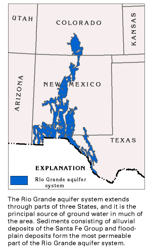
Rio Grande aquifer system

- Arizona, Colorado, New Mexico, and Utah (Chapter C)
- Oklahoma and Texas (Chapter E)
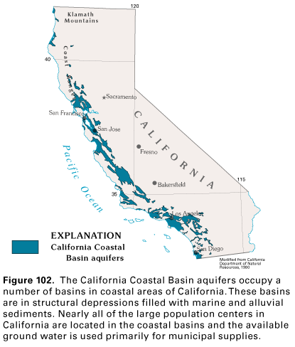
California Coastal Basin aquifers

- California and Nevada (Chapter B)
Central Valley aquifer system (California)

- California and Nevada (Chapter B)
Pacific Northwest basin-fill aquifers

- California and Nevada (Chapter B)
- Idaho, Oregon, and Washington (Chapter H)
Puget Sound aquifer system

- Idaho, Oregon, and Washington (Chapter H)
Willamette Lowland basin-fill aquifers

- Idaho, Oregon, and Washington (Chapter H)
Columbia Plateau basin-fill aquifers

- Idaho, Oregon, and Washington (Chapter H)
Snake River Plain basin-fill aquifers

- Idaho, Oregon, and Washington (Chapter H)
Northern Rocky Mountains Intermontane Basins aquifer system

- Montana, North Dakota, South Dakota, and Wyoming (Chapter I)
- Idaho, Oregon, and Washington (Chapter H)
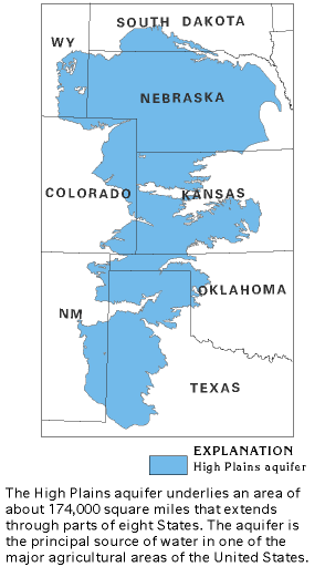
High Plains aquifer

- Montana, North Dakota, South Dakota, and Wyoming (Chapter I)
- Arizona, Colorado, New Mexico, and Utah (Chapter C)
- Kansas, Missouri, and Nebraska (Chapter D)
- Oklahoma and Texas (Chapter E)
Sand and gravel aquifers of alluvial and glaical origin
- Kansas, Missouri, and Nebraska (Chapter D)
- Montana, North Dakota, South Dakota, and Wyoming (Chapter I)
- Iowa, Michigan, Minnesota, and Wisconsin (Chapter J)
- Illinois, Indiana, Kentucky, Ohio, and Tennessee (Chapter K)
- Delaware, Maryland, New Jersey, North Carolina, Pennsylvania, Virginia, West Virginia (Chapter L)
- Connecticut, Maine, Massachusetts, New Hampshire, New York, Rhode Island, Vermont (Chapter M)
Pecos River Basin alluvial aquifer (Texas and New Mexico)

- Oklahoma and Texas (Chapter E)
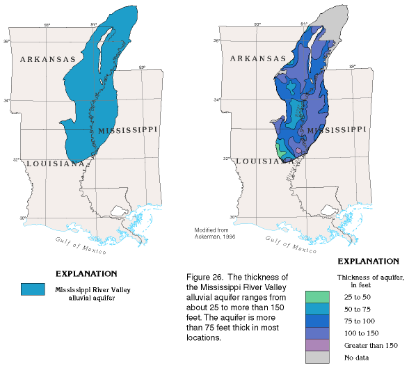
Mississippi River Valley alluvial aquifer

- Arkansas, Louisiana, and Mississippi (Chapter F)
- Kansas, Missouri, and Nebraska (Chapter D)
- Illinois, Indiana, Kentucky, Ohio, and Tennessee (Chapter K)
Seymour aquifer (Texas)

- Oklahoma and Texas (Chapter E)
Surficial aquifer system (eastern U.S.)

- Alabama, Florida, Georgia, and South Carolina (Chapter G)
- Delaware, Maryland, New Jersey, North Carolina, Pennsylvania, Virginia, West Virginia (Chapter L)
Unconsolidated-deposit aquifers (Alaska)

- Alaska, Hawaii, and Puerto Rico (Chapter N)
South Coast aquifer

- Alaska, Hawaii, and Puerto Rico (Chapter N)
Below are other web pages related to principal aquifers.
Unconsolidated and semiconsolidated sand and gravel aquifers
Below are publications associated with principal aquifers.
Ground Water Atlas of the United States Ground Water Atlas of the United States
Principal aquifers [of the United States] Principal aquifers [of the United States]
Unconsolidated sand and gravel principal aquifers of the United States, which are characterized by intergranular porosity and all contain water primarily under unconfined, or water-table, conditions.
To learn more, visit the Unconsolidated and Semiconsolidated Sand and Gravel Aquifers webpage for an overview, or access more extensive information from the Ground Water Atlas of the United States (USGS Hydrologic Atlas 730) by clicking on an individual region/chapter below.
Basin and Range basin-fill aquifers

- California and Nevada (Chapter B)
- Arizona, Colorado, New Mexico, and Utah (Chapter C)
Rio Grande aquifer system

- Arizona, Colorado, New Mexico, and Utah (Chapter C)
- Oklahoma and Texas (Chapter E)
California Coastal Basin aquifers

- California and Nevada (Chapter B)
Central Valley aquifer system (California)

- California and Nevada (Chapter B)
Pacific Northwest basin-fill aquifers

- California and Nevada (Chapter B)
- Idaho, Oregon, and Washington (Chapter H)
Puget Sound aquifer system

- Idaho, Oregon, and Washington (Chapter H)
Willamette Lowland basin-fill aquifers

- Idaho, Oregon, and Washington (Chapter H)
Columbia Plateau basin-fill aquifers

- Idaho, Oregon, and Washington (Chapter H)
Snake River Plain basin-fill aquifers

- Idaho, Oregon, and Washington (Chapter H)
Northern Rocky Mountains Intermontane Basins aquifer system

- Montana, North Dakota, South Dakota, and Wyoming (Chapter I)
- Idaho, Oregon, and Washington (Chapter H)
High Plains aquifer

- Montana, North Dakota, South Dakota, and Wyoming (Chapter I)
- Arizona, Colorado, New Mexico, and Utah (Chapter C)
- Kansas, Missouri, and Nebraska (Chapter D)
- Oklahoma and Texas (Chapter E)
Sand and gravel aquifers of alluvial and glaical origin
- Kansas, Missouri, and Nebraska (Chapter D)
- Montana, North Dakota, South Dakota, and Wyoming (Chapter I)
- Iowa, Michigan, Minnesota, and Wisconsin (Chapter J)
- Illinois, Indiana, Kentucky, Ohio, and Tennessee (Chapter K)
- Delaware, Maryland, New Jersey, North Carolina, Pennsylvania, Virginia, West Virginia (Chapter L)
- Connecticut, Maine, Massachusetts, New Hampshire, New York, Rhode Island, Vermont (Chapter M)
Pecos River Basin alluvial aquifer (Texas and New Mexico)

- Oklahoma and Texas (Chapter E)
Mississippi River Valley alluvial aquifer

- Arkansas, Louisiana, and Mississippi (Chapter F)
- Kansas, Missouri, and Nebraska (Chapter D)
- Illinois, Indiana, Kentucky, Ohio, and Tennessee (Chapter K)
Seymour aquifer (Texas)

- Oklahoma and Texas (Chapter E)
Surficial aquifer system (eastern U.S.)

- Alabama, Florida, Georgia, and South Carolina (Chapter G)
- Delaware, Maryland, New Jersey, North Carolina, Pennsylvania, Virginia, West Virginia (Chapter L)
Unconsolidated-deposit aquifers (Alaska)

- Alaska, Hawaii, and Puerto Rico (Chapter N)
South Coast aquifer

- Alaska, Hawaii, and Puerto Rico (Chapter N)
Below are other web pages related to principal aquifers.
Unconsolidated and semiconsolidated sand and gravel aquifers
Below are publications associated with principal aquifers.


