U.S. flag

An official website of the United States government

Images

Images intro.
Filter Total Items: 60
Desert scenery highlighting Saguaro cacti, desert vegetation, hills, and a paved trail.
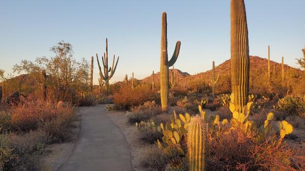
Desert Discovery Trail, Saguaro National Park (Elizabeth McCartney)

Desert scenery highlighting tall Saguaro cacti and other types of desert vegetation with a paved trail running through the middle. There are low hills in the distance and the scene is bathed in the soft yellow light of sunset.

Desert scenery highlighting tall Saguaro cacti and other types of desert vegetation with a paved trail running through the middle. There are low hills in the distance and the scene is bathed in the soft yellow light of sunset.

Blue background with dots connected by blue lines.
NDT Fall 2023 USGS Trail Data Portal

Title page with blue background with dots connected by blue lines used in NDT Fall 2023 newsletter

Title page with blue background with dots connected by blue lines used in NDT Fall 2023 newsletter

NDT Fall 2023 LOGIN.GOV Splash Screen

Screenshot of LOGIN.GOV sign-in for the TRAILS application used for NDT Fall 2023 newsletter

Screenshot of LOGIN.GOV sign-in for the TRAILS application used for NDT Fall 2023 newsletter

NDT Fall 2023 Sunbathing along the Florida Trails

Scene along the Florida Trail showing tropical foliage, water, and an alligator resting on the far shoreline

Group of people hiking on a trail in a tropical setting.   State: Florida
NDT Fall 2023 Walking along the Florida Trail

Group of people hiking on a trail in a tropical setting. The trail goes under a large live oak covered with moss.

Group of people hiking on a trail in a tropical setting. The trail goes under a large live oak covered with moss.

 A wooden bridge in a natural setting with people in the background. The image highlights a sign saying that volunteers are r
NDT Fall 2023 Florida Trail Volunteer Sign

A wooden bridge in a natural setting with people in the background. The image highlights a sign saying that volunteers are responsible for building and maintaining the Florida Trail.  

A wooden bridge in a natural setting with people in the background. The image highlights a sign saying that volunteers are responsible for building and maintaining the Florida Trail.  

A child riding a mountain bike on a trail in Golden Gate State Park in Colorado amidst the vibrant yellow colors of fall.
Fall 2023 Golden Gate State Park in the Fall

A child riding a mountain bike on a trail in Golden Gate State Park in Colorado amidst the vibrant yellow colors of fall.

Trails Explorer
NDT Summer 2023 8 - Trails Explorer

The image shows a screenshot of the Trails Explorer application. USGS Trail dataset is displayed in red color with USGS Topo map in the background.

The image shows a screenshot of the Trails Explorer application. USGS Trail dataset is displayed in red color with USGS Topo map in the background.

Remove User-added layer
NDT Summer 2023 - Remove User-added layer

The image shows a user-added layer in the legend and in the map view with a red cross-hatch over it to indicate the removal.

The image shows a user-added layer in the legend and in the map view with a red cross-hatch over it to indicate the removal.

Steps to remove user layers
NDT Summer 2023 - Steps to remove user layers

The image shows steps necessary to complete to remove user-added layers in TRAILS. One is to open Add Data panel. Two is to open link to view custom layers. Three is to click on the trash icon to remove the layer.

The image shows steps necessary to complete to remove user-added layers in TRAILS. One is to open Add Data panel. Two is to open link to view custom layers. Three is to click on the trash icon to remove the layer.

Access to USGS Trail Service
NDT Summer 2023 - Access to USGS Trail Service

The image shows steps necessary to complete to find USGS Trails Service. One is to open layers. Two is to open info about the Trails layer. Three is to open the description for the layer.

The image shows steps necessary to complete to find USGS Trails Service. One is to open layers. Two is to open info about the Trails layer. Three is to open the description for the layer.

Trails Explorer
NDT Summer 2023-9 - Trails Explorer

The image shows a screenshot of the Trails Explorer application. USGS Trail dataset is displayed in red color with USGS Topo map in the background.

The image shows a screenshot of the Trails Explorer application. USGS Trail dataset is displayed in red color with USGS Topo map in the background.

Looking out over Kodachrome State Park
NDT Summer 2023 - Looking out over Kodachrome State Park

Hiker with backpack and hiking pole looking out over red rock formations with blue sky and some white clouds. Photographer: Elizabeth McCartney

Spiral Jetty located near Rozel Point in Utah  
NDT Summer 2023 - Spiral Jetty located near Rozel Point in Utah  

The Spiral Jetty is an earthwork sculpture created in April 1970 and is located on the northeastern shore of the Great Salt Lake near Rozel Point in Utah. Photographer: John Todesco

The Spiral Jetty is an earthwork sculpture created in April 1970 and is located on the northeastern shore of the Great Salt Lake near Rozel Point in Utah. Photographer: John Todesco

Four screenshots of Crater Lake, Oregon shown with different degrees of detail. (read detailed description for more)
Crater Lake, Oregon - 4 Topo comparison maps

The image is a composite of four screenshots comparing four USGS topographic maps. The large screenshot at the top half of the image is an area around Crater Lake, Oregon, with a 1:100K US Topo sample at full resolution.

The image is a composite of four screenshots comparing four USGS topographic maps. The large screenshot at the top half of the image is an area around Crater Lake, Oregon, with a 1:100K US Topo sample at full resolution.

National Scenic and Historic Trail Map
National Scenic and Historic Trail Map-Fall 2022

The graphic is a map of the US with insets of Alaska and Hawaii. There are brightly colored lines depicting the routes of National Scenic and Historic trails. 

The graphic is a map of the US with insets of Alaska and Hawaii. There are brightly colored lines depicting the routes of National Scenic and Historic trails. 

TRAILS results with Custom Layer
TRAILS results with Custom Layer-Fall 2022

The graphic shows the proposed trail connectors. The results go around the custom layer of sensitive areas.

The graphic shows the proposed trail connectors. The results go around the custom layer of sensitive areas.

USGS Nationwide Trails
USGS Nationwide Trails-Fall 2022

The image above shows nationwide distribution of USGS trails data. Trails with national designations are displayed in red, pink, and blue. The rest of trails in the USGS dataset are displayed in yellow.  

The image above shows nationwide distribution of USGS trails data. Trails with national designations are displayed in red, pink, and blue. The rest of trails in the USGS dataset are displayed in yellow.  

Chalk Creek Canyon West of Buena Vista CO
Chalk Creek Canyon West of Buena Vista CO - Fall 2022

Trail located in Chalk Creek Canyon West of Buena Vista Colorado in fall of 2022

Mountain Biking Trail in Moab UT-Fall 2022
Trail Photo of the Month

A mountain biking trail in Moab, UT is marked as a red line on rock surface to guide the bikers on appropriate path.

A mountain biking trail in Moab, UT is marked as a red line on rock surface to guide the bikers on appropriate path.

Inka Trail
Inka Trail-Fall 2022

Stone pathway with steep vegetation covered slope on right side. Dropping off on left side with tall grass, shrubs, and trees in the distance. Partly cloudy sky with some blue showing.

Stone pathway with steep vegetation covered slope on right side. Dropping off on left side with tall grass, shrubs, and trees in the distance. Partly cloudy sky with some blue showing.

Was this page helpful?