
National Earthquake Information Center (NEIC)
The National Earthquake Information Center (NEIC), was established in Rockville, Maryland, in 1966 as part of the National Ocean Survey of the Department of Commerce. The Coast and Geodetic Survey, a forerunner of the National Ocean Survey, had coordinated the collection of seismological data in the United States for many years
The NEIC was transferred to Boulder, Colorado, in 1972 and made part of the U.S. Geological Survey in 1973. The NEIC was moved again in 1974 to its present location in Golden, Colorado.

The National Earthquake Information Center (NEIC), a part of the Department of the Interior, U.S. Geological Survey, is located in Golden, Colorado, 10 miles west of Denver. The NEIC has three main missions. First, the NEIC determines, as rapidly and as accurately as possible, the location and size of all significant earthquakes that occur worldwide. The NEIC disseminates this information immediately to concerned national and international agencies, scientists, critical facilities, and the general public. Second, the NEIC collects and provides to scientists and to the public an extensive seismic database that serves as a solid foundation for scientific research, principally through the operation of modern digital national and global seismograph networks and through cooperative international agreements. The NEIC is the national data center and archive for earthquake information. Third, the NEIC pursues an active research program to improve its ability to locate earthquakes and to understand the earthquake mechanism. These efforts are all aimed at mitigating the risks of earthquakes to mankind; and they are made possible by the fine international cooperation that has long characterized the science of seismology.

The NEIC operates a 24-hour-a-day service to determine the location and magnitude of significant earthquakes in the United States and around the world as rapidly and accurately as possible. This information is communicated to federal and state government agencies who are responsible for emergency response, to government public information channels, to national and international news media, to scientific groups (including groups planning aftershock studies), and to private citizens who request information. When a damaging earthquake occurs in a foreign country, the earthquake information is passed to the staffs of the American embassies and consulates in the affected countries and to the United Nations Department of Humanitarian Affairs (DHA). The NEIC issues rapid reports for those earthquakes with magnitudes at least 3.0 in the eastern United States, 3.0 in the western United States, or 5.0 (or are known to have caused damage) anywhere else in the world. At the present time, the NEIC staff locates and publishes approximately 30,000 earthquakes on a yearly basis. These are the most important of the many million earthquakes which are estimated to occur each year.

The NEIC collects data through the operation of national and global networks, and through cooperative agreements. To enable the detection and location of all felt earthquakes with the U.S., the NEIC acts as the National Operations Center of the Advanced National Seismic System (ANSS), a cooperative venture between the NEIC and the operators of the regional seismic networks across the United States. The NEIC also relies on the cooperation of a variety of seismic reporting networks throughout the world to gather data. The NEIC also collects non-instrumental reports of the effects of earthquakes on people and man-made structures and prepares isoseismal maps showing the distribution of intensities in widely felt or damaging shocks.
The data that are collected by the NEIC are published in a variety of formats and publications and are available electronically via the Internet. The "Quick Epicenter Determinations" (QED), a very preliminary list of earthquakes, is computed daily. The "Preliminary Determination of Epicenters" (PDE) is published weekly and monthly. The "Earthquake Data Report" (EDR), also a monthly publication, provides additional and more detailed information, mainly for the use of seismologists.
A wide range of research is also conducted at the NEIC. Investigations range from resolving the internal structure of the Earth and understanding the mechanics of earthquake rupture through rapid assessment of an earthquake's impact. These research efforts are intended to improve the data service provided by the NEIC to the scientific community and the general public; and, ultimately, to aid in earthquake hazard mitigation.
See also: Building a National Seismic Monitoring Center: NEIC from 2000 to the Present
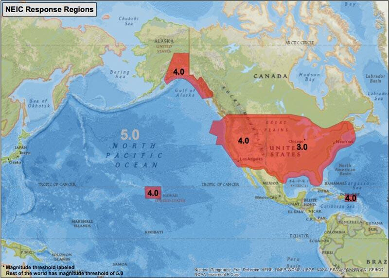
"Response Events" and Processing Priorities
NEIC targets a 20-minute release time for response events. An earthquake is considered a response event when the event exceeds a threshold magnitude. Due to later arriving data and contributed solutions, this may not occur within the 20-minute target window, and in the case of "slow” (low-frequency content) earthquakes, it can be days or weeks before an event is discovered. In sparsely instrumented regions, an event meeting the response criteria may not have sufficient data to locate or publish, even for the final catalog. Events may also have a magnitude below this response threshold when they are processed by our automatic system and after manually processing their magnitude may exceed the threshold. As a result, the release of such events will be delayed.
Response events (target release time less than 20 minutes):
- M3.0 or larger
- Eastern US (roughly east of -105 degrees)
- M4.0 or larger
- Western U.S. (roughly west of -105 degrees)
- Hawaii
- Puerto Rico, Virgin Islands
- Populated Alaska
- M5.0 or larger, all other parts of the world
- In addition, some earthquakes with magnitudes below these thresholds will also be reviewed on an immediate basis. These include earthquakes in high-risk areas likely to cause multiple fatalities or significant damage or events which have been felt widely in densely populated parts of the world.
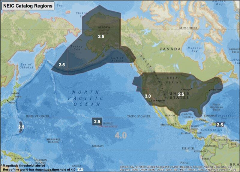
Events with smaller magnitudes than the response criteria will be processed in the catalog processing time frame. This process can take up to 10 weeks although most events are finalized within 6 weeks. The criteria for publishing catalog events are as follows:
- M2.5 or larger or felt in the U.S. (excluding California)
- M3.0 or larger in California
- M4.0 or larger or felt all other regions throughout the world
These criteria support a goal of about M4.5 global completeness and about M3.0 U.S. completeness.
Published events must have a minimum of 5 phase timing observations (P or S) used in the solution, an RMS error of less than 2.0 (less than 1.5 strongly preferred) and have "reasonable" station coverage to be published. Events not meeting these criteria will not be published even if the magnitude threshold is exceeded. As a result, small earthquakes in regions with sparse instrumentation may not be published or even discovered.
See also: Building a National Seismic Monitoring Center: NEIC from 2000 to the Present