
What a difference 100 years make!
What a difference 100 years make!
-----
In recognition of World Water Day and in conjunction with the White House Water Summit, the U.S. Geological Survey is raising awareness of water issues and potential solutions in the United States.
-----
This year’s theme for the United Nation’s World Water Day is water and jobs. Today, almost half of the world’s workers – 1.5 billion people – work in water-related sectors, and nearly all jobs depend on water. At the USGS Texas Water Science Center, scientists have been working to provide critical, unbiased water science to the community for more than 100 years.
Many resource managers and emergency managers rely on USGS streamflow data to make informed decisions – whether it’s during flood response or determining how much water can be used while still maintaining healthy ecosystems. In years past, this vital information wasn’t always easy to get or available in real time. So, how far have our science capabilities grown? To find out, let’s take a look at how science has developed over the past century at the USGS and especially at the Texas Water Science Center.
More than 100 Years of Science in Texas
A USGS Texas district office opened its doors in Austin on September 1, 1915, according to historical records. At that time there were 18 streamgages in operation, 14 of which were installed by the Texas Board of Water Engineers (now the Texas Water Development Board), and four established by the USGS.
During that time, the first USGS District Engineer noted, “The importance of streamflow data in Texas will warrant the installation of several hundred stations.”
Today, the USGS operates more than 700 real-time streamflow and lake level gages in Texas.


USGS streamgaging and other water resource activities in Texas began before 1915 but were conducted largely by employees that were paid by the day or by staff that traveled to Texas to conduct seasonal work. Thomas Uluvan Taylor, Professor of Civil Engineering at The University of Texas, was the first per diem employee, and began collecting data for the USGS in 1898.


Centennial Streamgages
The earliest streamgage site in Texas was established 17 years before the permanent USGS office in Texas opened its doors. In May of 1889, H.M. Dyar and J.B. Williams used a boat and cable to set up a streamgage on the Rio Grande at El Paso, which was near the old Fort Bliss. Dyar and Williams were members of the first organized training and testing streamgaging effort at the USGS, which was based out of the Camp of Instruction in Embudo, New Mexico. Dyar was assigned to measure streamflow and silt content on a daily basis at the Rio Grande Station. Since this site was close to Mexico, it shortly thereafter became managed by the International Boundary and Water Commission (formerly the International Boundary Commission).
The oldest USGS centennial gage began collecting data on March 1, 1898, on the Colorado River in Austin, Texas (site number 0815800), and data collection continues today. The current cooperator for this gage is the Lower Colorado River Authority. The original location was on Congress Avenue, but was moved downstream to east of Longhorn Dam when Ladybird Lake was formed.
So strong was public interest in streamgaging that, on the establishment of one station, T.U. Taylor was escorted to the site by a large contingent of citizens (although perhaps lacking the proverbial brass band) that watched in awe of the measurement. When told that the meter used was electric, their faith in its accuracy was unbounded because the term “electric” signified marvelous qualities.


Seventeen sites are “centennial” streamgages in Texas. Each site wears a badge of honor on the USGS National Water Information System webpage (you can see an example here). Each of the streamgages below has a cooperator that helps to fund data collection and water resource assessments. These partnerships are often with local, state, federal and tribal resource agencies that rely on streamflow information for local water and resource management.
Station NameSite NumberData Collection StartCurrent Cooperator
- Colorado River at Austin, 08158000, 03/01/1898, Lower Colorado River Authority
- Brazos RiverRv at Waco, TX, 08096500, 10/01/1898, U.S. Army Corps of Engineers
- Brazos River at Richmond, 08114000, 01/01/1903 , USGS National Groundwater and Streamflow Monitoring Program
- Sabine River at Logansport, La., 08022500, 07/01/1903, Sabine River Compact Administration
- Neches River near Rockland, 08033500, 07/01/1903, Lower Neches Valley Authority
- Trinity River at Dallas, 08057000, 10/01/1903, U.S. Army Corps of Engineers, City of Dallas, City of Ft. Worth,Trinity River Authority
- Elm Fk Trinity River near Carrollton, 08055500, 01/01/1907, U.S. Army Corps of Engineers
- Colorado River near Ballinger, 08126380, 06/01/1907, Colorado River Municipal Water District
- Nueces River near Three Rivers, 08210000, 07/07/1915, USGS National Groundwater and Streamflow Monitoring Program
- Frio River near Derby, 08205500, 08/01/1915, City of Corpus Christi
- Concho River at Paint Rock, 08136500, 10/01/1915, USGS National Groundwater and Streamflow Monitoring Program
- Concho River at San Angelo, 08136000, 10/01/1915, City of San Angelo
- San Saba River at Menard, 08144500, 10/01/1915, Lower Colorado River Authority
- San Saba River at San Saba, 08146000, 10/01/1915, Lower Colorado River Authority
- Colorado River near San Saba, 08147000, 10/01/1915, Lower Colorado River Authority
- N Llano River near Junction, 08148500, 10/01/1915, USGS National Groundwater and Streamflow Monitoring Program
- Llano River near Junction, 08150000, 10/01/1915, Lower Colorado River Authority
We’ve Come A Long Way
Nationwide, the USGS has about 7,000 streamgages with more than 500 being in Texas, where there are more than 140 scientists and other team members. What a difference a century makes!
Take a look at this Dallas streamgage site on the Trinity River. The older photos were taken in 1922, and the newer photo was taken in 2014. The streamgage has been moved from being mounted on the bridge and now resides next to the stream to measure high flows.


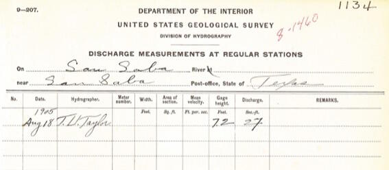
Streamflow measurements used to be measured and recorded by hand, as shown in these photos from the San Saba River.


Now, measurements are automatically relayed to USGS offices by satellite, telephone and/or radio telemetry and are available for viewing within a few minutes of arrival. You can check out real-time streamflow throughout Texas by visiting our USGS WaterWatch website.

Fun fact: Why does the USGS spell streamgage without a “u”?
Around 1892, the USGS changed the spelling from “gauge” to “gage.” The “u” had been inserted as a result of Norman influence on the language, and to keep with the times, the USGS began spelling the word in the Saxon way. At the same time, the Standard Dictionary also adopted “gage” as part of their reference.
Citizen Science: Take A Trip Through Time in Texas!
Can you look through the streamflow record and identify the highest or lowest streamflows recorded for any of the USGS Texas centennial streamgages?
Locate USGS Texas centennial streamgages and see where water comes from or where water is going at USGS Streamer.
Or, go on an adventure and identify one of the USGS Texas centennial streamgages in person! If you do, please share you photos with the hashtag #USGSgage on Twitter, Instagram or Facebook. Be sure to also tag USGS!!
By using the hashtag and tagging USGS, you’re giving us permission to use your images on USGS social media accounts. Remember to be safe when taking photos – don’t walk near traffic, go into high-flowing streams or put yourself at risk of falling off bridges.