
Living in the Outer Banks means living with the power of the sea. Jutting out from North Carolina’s coast into the Atlantic Ocean, this series of sandy barrier islands is particularly vulnerable to damage from major storms. In April 2016, another nor’easter was set to strike, but this time, Dare County officials were approached by their local weather forecaster with a new kind of prediction.
“It was relatively new, so it didn’t really grab our attention at first,” said Drew Pearson, Dare County’s Emergency Management Director, of the technology used by Rich Bandy, Meteorologist-In-Charge of the National Weather Service’s (NWS) Morehead City, N.C., office. But Bandy’s prediction—that the ocean would “overwash” the dunes in Kitty Hawk, N.C.—turned out to be true.
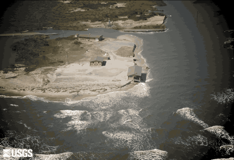
Hundreds of miles of tall sand dunes serve as a formidable barrier for Outer Banks residents against the flooding. Storm-driven waves and water can attack, and occasionally even overtop, dunes and cause flooding that can damage homes, businesses, and infrastructures such as roads and power lines. During and after a storm, transporting emergency workers to flooded areas can take precious time and resources, and escape routes for residents can be cut off by flooding. Anticipating flood zones from an approaching storm can save time, money, and lives.

Bandy and his team use computer models to help predict wave size and water levels, but these models often lack precision on a local scale. The models are based on conditions in the open ocean, not at the coast, where slope and terrain can vary greatly from year to year and even storm to storm.
“We had an idea of what the waves were going to be, [but] we really couldn’t accurately forecast the wave run-up component at the coast and get a good assessment of where the worst erosion and inundation was going to be,” Bandy said.
What Bandy needed was a model that accounted for waves breaking on the beach, for the shifting shape of the Outer Banks’ beaches and dunes, and how and where the interaction could cause coastal erosion.
“That’s information the U.S. Geological Survey [USGS] can provide,” said Hilary Stockdon, project lead for the USGS National Assessment of Coastal Change Hazards (NACCH).
The USGS created a model that accurately predicts which areas of the beach are at risk to overwash or flooding from impending nor’easters and hurricanes. Combined with the offshore wave forecasts of the NWS, meteorologists like Bandy can now speak in specifics when warning officials and residents. The USGS created the model using more than a decade of carefully gathered data on how storms affect coastlines and by merging models of coastal waves and water levels with detailed mapping.


“It’s evolved into a great collaborative process,” Bandy said.
Using USGS data and models, Bandy warned Dare County officials that the Kitty Hawk area would likely see waves reaching—and in places, overwashing—the dunes and road when the nor’easter hit in April. Although the dunes were rebuilt, other storms are sure to come, and Pearson’s skepticism has been replaced with gratitude for these new predictions. More recently, Dare County officials even used the USGS forecast for Hurricane Hermine this past September.
“It’s adding to our toolbox as emergency managers,” Pearson said.
Expanded collaboration, although still in its infancy, is expected for areas up and down the East and Gulf Coasts. As climate change increases the potential for more and stronger storms in the future, Bandy sees great promise in collaborating with the USGS.
“We’re trying to evolve a weather-ready Nation,” Bandy said. “Anytime we can get more specific information to target certain areas and certain impacts, it really helps us to communicate what people need to be prepared for.”
A national assessment of coastal change in response to storms, sea-level rise, and erosion can be found on the USGS Coastal Change Hazards Portal. Browse USGS resources online to learn more about coastal change hazards.


Read more stories about USGS science in action.