New USGS Strategy Harnesses State-of-the-Art Science to Tackle Wildfires Before, During and After the Flames
New USGS Strategy Harnesses State-of-the-Art Science to Tackle Wildfires Before, During and After the Flames
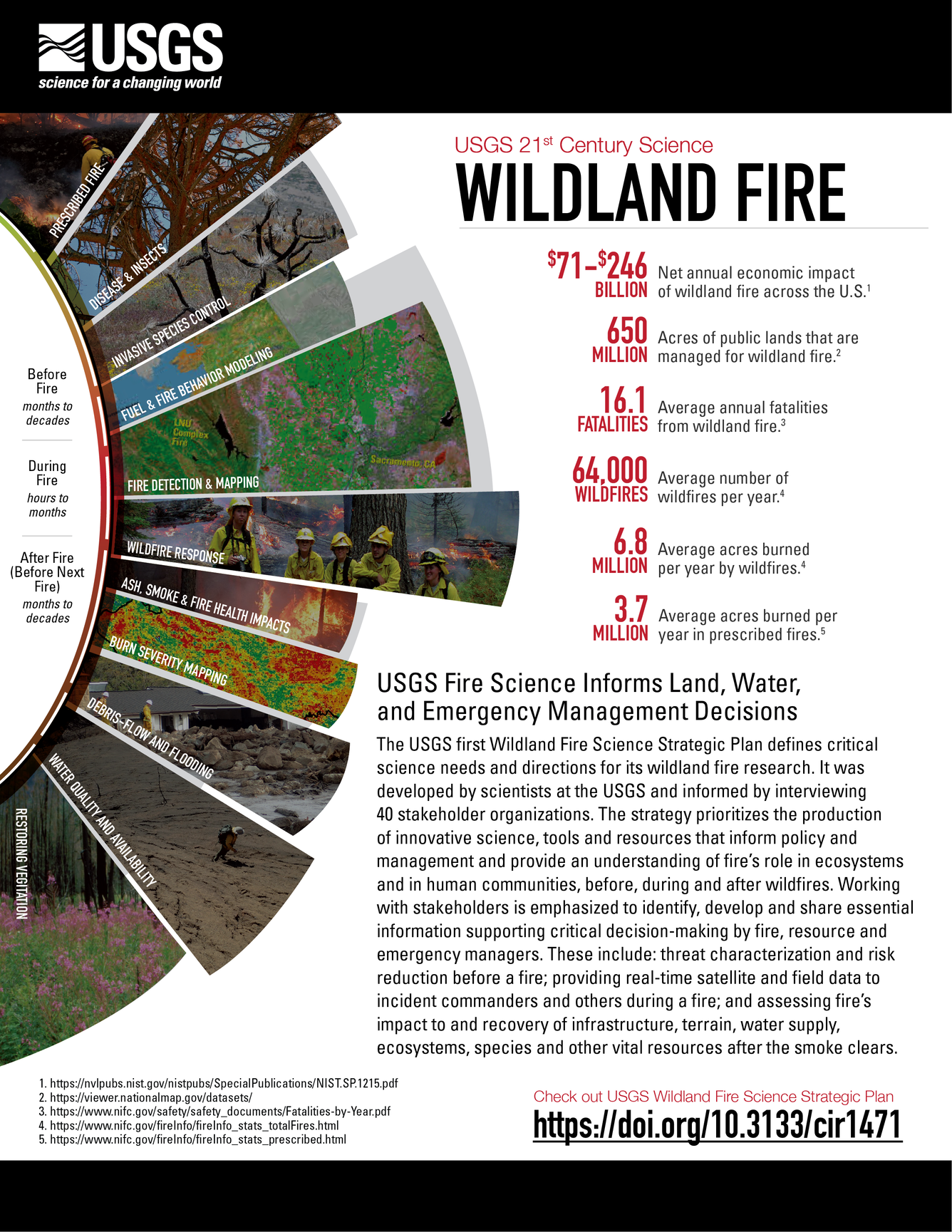
To help address growing wildfire-related challenges in America, the U.S. Geological Survey is rolling out a new Wildland Fire Science Strategy that lays out the critical needs for wildfire research over the next five years. Released today, this strategy can be used to better understand the balance between fire’s benefits and its detrimental impacts.

Wildfires in the United States can be devastating, with 2017, 2018 and 2020 being particularly damaging and deadly years. The new fire strategy will guide future USGS research and help the agency provide timely and relevant information for land managers to tackle fire risks before they occur, during wildfire response and after the flames go out. It also addresses emerging priorities such as climate change and supporting underserved rural communities and tribes.
“Now is the time to act, and USGS science is leading the way,” said David Applegate, Associate Director for Natural Hazards, exercising the delegated authority of the Director, U.S. Geological Survey. “This new fire science strategy provides the roadmap for developing the research, data and technologies that are critically needed to help the country better face future wildfire challenges.”
The USGS employs more than 100 scientists whose research focuses on fire-related topics, including using high-resolution remote sensing to characterize vegetative fuel loads; applying the latest satellite technology to detect fires and map wildfire perimeters; evaluating best practices to reduce wildfire risks; and assessing post-wildfire flooding and debris-flow hazards. This work also includes creating and sharing best practices to support recovery across landscapes. Together, USGS expertise and monitoring capabilities are greatly improving the safety of first responders and the public-at-large.

The new strategy also emphasizes the importance of bridging fire and post-fire science to develop the most effective response, recovery and pre- and post-fire mitigation strategies to reduce risk. It highlights the use of computer simulations to help predict burn severity, which can then pinpoint areas that would likely be vulnerable to hazards during and after fires. Recognizing that post-fire hazards span many branches of science, the strategy integrates different research branches to improve planning for and response to fire-related disasters.
“Cutting-edge research and multidisciplinary teamwork are key to better understanding and addressing wildfire challenges in the 21st century,” said Anne Kinsinger, Associate Director for USGS Ecosystems. “Scientists from different fields – fire ecology, hydrology, geology, remote sensing and botany – are pooling their expertise to evaluate wildfires, linking initial fire behavior to post-fire hazards and applying that information to ecosystem recovery.”
Researchers across the USGS are working with the interagency fire community to expand the use of artificial intelligence, machine learning and other rapid-computing capabilities. For example, the USGS uses artificial intelligence with satellite imagery to detect fire boundaries and develop burn severity maps, and to identify distribution and abundance of fire-adapted invasive species like cheatgrass in the Great Basin.

“This strategy will help the local, state, tribal and federal collaboration to address the wildfire issue that our nation is experiencing,” said Jeff Rupert, Director of the Department of the Interior’s Office of Wildland Fire. “The science needs identified in the strategy will support firefighters that respond to wildfires and prevention efforts to protect communities, resources and people.”
For example, the USGS is partnering with the Los Alamos National Laboratory and Tall Timbers Research Station to model fire behavior, fire weather patterns, 3D fuel loads and smoke conditions to evaluate how fuel treatments can reduce fire risk across a changing landscape. The USGS is also strengthening its partnerships with the Fire Science Exchange Network to foster increased access and use of its fire information, data and tools while learning about needs of practitioners in the field.
The USGS Wildland Fire Science Strategy aligns with national initiatives as defined in the National Cohesive Wildland Fire Management Strategy. Developed by a broad swath of stakeholders at all levels, the Cohesive Strategy calls for science and management that promote resilient landscapes and fire-adapted communities for safe and effective wildfire responses.
For more details about the new USGS Wildland Fire Science 2021-2026 Strategic Plan, read the full report.
For more information about USGS fire science, visit www.usgs.gov/fire.