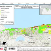
Steven Sobieszczyk is a scientist and spokesperson. While "Sobie" spent most of his career researching landslide hazards, flooding, sediment transport, and stream ecosystems, he now focuses more on science communication and promoting scientific literacy. Steve is a multihazard first responder and has spoken extensively about seismic, wildfire, landslide, flooding, and volcanic hazards.
CURRENT WORK
- Media Lead for the USGS Natural Hazards Mission Area
- Public Information Officer for DOI Office of Wildland Fire
- Hydrologist for National DOI Burned Area Emergency Response (BAER) Team
Professional Experience
Public Affairs Specialist • U.S. Geological Survey • 2019 – Present
Develop, create, and execute national-level Bureau communication content (e.g., news releases, social media posts, videos), events (e.g., open houses, press conferences), and media & science communications training. Writer. Illustrator. Videographer. Webmaster. Instructor. Public Speaker.
Public Information Officer & Hydrologist • U.S. Department of Interior • 2017 – Present
Multi-incident first responder. Create talking points, press releases, videos, social media content, and online story maps. Coordinate community meetings and press conferences. DOI Burned Area Emergency Response hydrologist.
Co-founder • Association of Science Communicators • 2016 – Present
Founding member and executive officer of an international non-profit science communication organization. Help guide internal/external communication and community marketing strategies, including graphic design, branding, and conference development.
Geographer & Hydrologist • U.S. Geological Survey • 2001 – 2019
Study debris flow, flooding, and sediment transport-related issues. Professional background in GIS, including runoff modeling and bathymetric surveys. Advised Leadership on strategies and methods to achieve better public understanding of science content.
Adjunct Professor • Portland State University • 2011 – 2017
Taught Hydrology (GEOG 4/514), GIS for Water Resources (GEOG 4/594), River Restoration, Part II: Ecological Processes (EPP 222), and Site Evaluation and Assessment Tools (EPP 223).
Research Assistant • NASA • 1999
Mapped, analyzed, and compiled a database of crater impacts on Ganymede, the largest moon of Jupiter, using Galileo and Viking satellite images.
Education and Certifications
Portland State University • M.S. • 2010
Certificates in Landslide Engineering Geology and Hydrology.
Portland State University • GISP • 2005
Licensed Geographic Information Systems (GIS) Professional
University of Wisconson - Oshkosh • B.S. • 2000
Major in Geology with a Minor in Geography.
Science and Products
Steven is interested in landslide hazards, sediment transport, water quality, and stream ecosystems and has published numerous scientific reports, journal articles, and data sets on these topics (see subject links below for respective publications).
I Am A...Science careers book for kids
Postfire debris flow hazards—Tips to keep you safe
How USGS gages are used in flood forecasting
The U.S. Geological Survey (USGS) operates an extensive nationwide network of stream, rain, and groundwater gages. These instruments are used to monitor how much water there is across the Nation at any given moment. Stream data are collected at streamgages every 15 minutes, transmitted to USGS servers, and updated online in real time. To improve awareness of current water conditions and possible f
Building a landslide hazard indicator with machine learning and land surface models
Prioritization framework for ranking riverine ecosystem stressors using example sites from the Tualatin River Basin, Oregon
Klamath River Basin water-quality data
Water-quality conditions and suspended-sediment transport in the Wilson and Trask Rivers, northwestern Oregon, water years 2012–14
Organic matters: investigating the sources, transport, and fate of organic matter in Fanno Creek, Oregon
Investigating organic matter in Fanno Creek, Oregon, Part 1 of 3: estimating annual foliar biomass for a deciduous-dominant urban riparian corridor
Investigating organic matter in Fanno Creek, Oregon, Part 3 of 3: identifying and quantifying sources of organic matter to an urban stream
Investigating organic matter in Fanno Creek, Oregon, Part 2 of 3: sources, sinks, and transport of organic matter with fine sediment
Geomorphic setting, aquatic habitat, and water-quality conditions of the Molalla River, Oregon, 2009-10
Non-USGS Publications**
**Disclaimer: The views expressed in Non-USGS publications are those of the author and do not represent the views of the USGS, Department of the Interior, or the U.S. Government.
I Am A...Natural Resource Economist
Welcome to the "The I Am A..." series, a whiteboard animation video series highlighting USGS careers. The concept is to show whimsically "what society (or my mom) thinks I do" compared with "what I really do." This video is about a natural resource economist (i.e. someone who studies the value of features in the natural world).
I Am An...Ecotoxicologist
Welcome to the "The I Am A..." series. This is the tenth video in a series of USGS whiteboard animations that highlight USGS careers. The concept is to show "what society (or my mom) thinks I do" compared with "what I really do." One image captures a more whimsical representation of a "scientist" and the second demonstrates a more accurate representation of
I Am A...Climate Modeler
Welcome to the "The I Am A(n)..." series. This is the seventh video in a series of USGS whiteboard animations that highlight USGS careers. The concept is to show "what society (or my mom) thinks I do" compared with "what I really do." One image captures a more whimsical representation of a "scientist" and the second demonstrates a more accurate representation of what we really look like in the field.
In this episode, we explore a Climate Modeler (i.e., a person who forecasts future climate scenarios).
Below we feature the animated video and a coloring page.
I Am A...Wildlife Biologist
Welcome to the "The I Am A(n)..." series. This is the seventh video in a series of USGS whiteboard animations that highlight USGS careers. The concept is to show "what society (or my mom) thinks I do" compared with "what I really do." One image captures a more whimsical representation of a "scientist" and the second demonstrates a more accurate representation of what we really look like in the field.
In this episode, we explore a Wildlife Biologist (i.e., person who studies animals in the wild).
Below we feature the animated video and a coloring page.
I Am A...Wetland Ecologist
Welcome to the "The I Am A(n)..." series. This is the seventh video in a series of USGS whiteboard animations that highlight USGS careers. The concept is to show "what society (or my mom) thinks I do" compared with "what I really do." One image captures a more whimsical representation of a "scientist" and the second demonstrates a more accurate representation of what we really look like in the field.
In this episode, we explore a Wetland Ecologist (i.e., person who studies wetland plants and animals).
Below we feature the animated video and a coloring page.
I Am A...Malacologist
Welcome to the "The I Am A(n)..." series. This is the sixth video in a series of USGS whiteboard animations that highlight USGS careers. The concept is to show "what society (or my mom) thinks I do" compared with "what I really do." One image captures a more whimsical representation of a "scientist" and the second demonstrates a more accurate representation of what we really look like in the field.
In this episode, we explore a Malacologist who is someone who studies mollusks, the most diverse group of animals on the planets and includes mussels, snails, octopuses, clams, scallops, oysters, and MANY more (like tens of thousands of organisms).
Below we feature the animated video and a coloring page.
I Am A(n)...Ichthyologist
I Am A(n) ... Ichthyologist is part of our "I Am A..." series of USGS whiteboard animations that highlight USGS careers. The concept is to show "what society (or my mom) thinks I do" compared with "what I really do." One image captures a more whimsical representation of a "scientist" in the field and the second demonstrates a more accurate representatio
I Am A...Chiropterologist
I Am A ... Chiropterologist is part of our "I Am A..." series of USGS whiteboard animations that highlight USGS careers. The concept is to show "what society (or my mom) thinks I do" compared with "what I really do." One image captures a more whimsical representation of a "scientist" in the field and the second demonstrates a more accurate represen
I Am A ... Fire Ecologist
I Am A ... Fire Ecologist is part of our "I Am A..." series of USGS whiteboard animations that highlight USGS careers. The concept is to show "what society (or my mom) thinks I do" compared with "what I really do." One image captures a more whimsical representation of a "scientist" in the field and the second demonstrates a more accurate representation of what we really look like. Next up Fire Ecologist.
A Fire Ecologist is someone who studies fire behavior and its effects! The USGS has lot of scientists that do this.
Below we feature the animated video and a coloring page.
I Am A ... Herpetologist
I Am A ... Herpetologist is part of our "I Am A..." series of USGS whiteboard animations that highlight USGS careers. The concept is to show "what society (or my mom) thinks I do" compared with "what I really do." One image captures a more whimsical representation of a "scientist" in the field and the second demonstrates a more accurate representation of what we really look like.
A Herpetologist is someone who studies amphibians and reptiles! The USGS Amphibian Research and Monitoring Initiative is an "ARMI" of scientists that do this.
Below we feature the animated video and a coloring page.
I Am An ... Ornithologist
I Am An ... Ornithologist is part of our "I Am A..." series of USGS whiteboard animations that highlight USGS careers. The concept is to show "what society (or my mom) thinks I do" compared with "what I really do." One image captures a more whimsical representation of a "scientist" in the field and the second demonstrates a more accurate representation of what we really look like.
An Ornithologist is someone who studies birds! The USGS has lot of scientists that do this.
Below we feature the animated video and a coloring page.
Map and map database of susceptibility to slope failure by sliding and earthflow in the Oakland area, California
When it comes to talking to others, especially when explaining science, the key is consequences outweigh precision. You should always be honest, tell the truth, but don't sweat the small stuff. People care about relatability, not the mundane. Knowing what information isn't worth sharing is hard. There are professionals out there who can help. Like me.
Science and Products
- Publications
Steven is interested in landslide hazards, sediment transport, water quality, and stream ecosystems and has published numerous scientific reports, journal articles, and data sets on these topics (see subject links below for respective publications).
Filter Total Items: 39I Am A...Science careers book for kids
This activity book is an illustrative guide designed to introduce young minds about the exciting world of science careers. From ichthyologists to wildlife biologists, this book showcases a variety of science-based professions through fun and engaging activities. Each section of the book features a different science career and includes information about how the job got its name and what a typical dAuthorsSteven Sobieszczyk, Suzanna C. Soileau, Annie ScottPostfire debris flow hazards—Tips to keep you safe
Often referred to as “mudflows,” debris flows are a type of landslide made up of a rapidly moving mixture of dirt, rocks, trees, and water (and sometimes ash) that start on a hillside and travel downvalley. They can easily overflow channels and severely damage houses, vehicles, or other structures. Areas burned by wildfires are especially susceptible to these hazards, which can be triggered by stoAuthorsSteven Sobieszczyk, Jason W. KeanHow USGS gages are used in flood forecasting
The U.S. Geological Survey (USGS) operates an extensive nationwide network of stream, rain, and groundwater gages. These instruments are used to monitor how much water there is across the Nation at any given moment. Stream data are collected at streamgages every 15 minutes, transmitted to USGS servers, and updated online in real time. To improve awareness of current water conditions and possible f
AuthorsSteven SobieszczykBuilding a landslide hazard indicator with machine learning and land surface models
The U.S. Pacific Northwest has a history of frequent and occasionally deadly landslides caused by various factors. Using a multivariate, machine-learning approach, we combined a Pacific Northwest Landslide Inventory with a 36-year gridded hydrologic dataset from the National Climate Assessment – Land Data Assimilation System to produce a landslide hazard indicator (LHI) on a daily 0.125-degree griAuthorsT. A. Stanley, D. B. Kirschbaum, Steven Sobieszczyk, M. F. Jasinski, J. S. Borak, Stephen L. SlaughterPrioritization framework for ranking riverine ecosystem stressors using example sites from the Tualatin River Basin, Oregon
As human populations increase, so does their influence over the environment. Altered terrain, degraded water quality, and threatened or endangered species are all-too-common consequences of a growing anthropogenic influence on the landscape. To help manage these effects, researchers have developed new ways to characterize current environmental conditions and help resource managers seek solutions tAuthorsSteven Sobieszczyk, Krista L. Jones, Stewart A. Rounds, Elena B. Nilsen, Jennifer L. MoraceKlamath River Basin water-quality data
The Klamath River Basin stretches from the mountains and inland basins of south-central Oregon and northern California to the Pacific Ocean, spanning multiple climatic regions and encompassing a variety of ecosystems. Water quantity and water quality are important topics in the basin, because water is a critical resource for farming and municipal use, power generation, and for the support of wildlAuthorsCassandra D. Smith, Stewart A. Rounds, Leonard L. OrzolWater-quality conditions and suspended-sediment transport in the Wilson and Trask Rivers, northwestern Oregon, water years 2012–14
In October 2011, the U.S. Geological Survey began investigating and monitoring water-quality conditions and suspended-sediment transport in the Wilson and Trask Rivers, northwestern Oregon. Water temperature, specific conductance, turbidity, and dissolved oxygen were measured every 15–30 minutes in both streams using real-time instream water-quality monitors. In conjunction with the monitoring effAuthorsSteven Sobieszczyk, Heather M. Bragg, Mark A. UhrichOrganic matters: investigating the sources, transport, and fate of organic matter in Fanno Creek, Oregon
The term organic matter refers to the remnants of all living material. This can include fallen leaves, yard waste, animal waste, downed timber, or the remains of any other plant and animal life. Organic matter is abundant both on land and in water. Investigating organic matter is necessary for understanding the fate and transport of carbon (a major constituent of organic matter). Organic matter isAuthorsSteven Sobieszczyk, Mackenzie K. Keith, Jami H. Goldman, Stewart A. RoundsInvestigating organic matter in Fanno Creek, Oregon, Part 1 of 3: estimating annual foliar biomass for a deciduous-dominant urban riparian corridor
For this study, we explored the amount, type, and distribution of foliar biomass that is deposited annually as leaf litter to Fanno Creek and its floodplain in Portland, Oregon, USA. Organic matter is a significant contributor to the decreased dissolved oxygen concentrations observed in Fanno Creek each year and leaf litter is amongst the largest sources of organic matter to the stream channel andAuthorsSteven Sobieszczyk, Mackenzie K. Keith, Stewart A. Rounds, Jami H. GoldmanInvestigating organic matter in Fanno Creek, Oregon, Part 3 of 3: identifying and quantifying sources of organic matter to an urban stream
The sources, transport, and characteristics of organic matter (OM) in Fanno Creek, an urban stream in northwest Oregon, were assessed and quantified using: (1) optical instruments to calculate transported loads of dissolved, particulate, and total organic carbon, (2) fluorescence spectroscopy and stable isotope ratios (δ13C, δ15N) to elucidate sources and chemical properties of OM throughout the bAuthorsJami H. Goldman, Stewart A. Rounds, Mackenzie K. Keith, Steven SobieszczykInvestigating organic matter in Fanno Creek, Oregon, Part 2 of 3: sources, sinks, and transport of organic matter with fine sediment
Organic matter (OM) is abundant in Fanno Creek, Oregon, USA, and has been tied to a variety of water-quality concerns, including periods of low dissolved oxygen downstream in the Tualatin River, Oregon. The key sources of OM in Fanno Creek and other Tualatin River tributaries have not been fully identified, although isotopic analyses from previous studies indicated a predominantly terrestrial sourAuthorsMackenzie K. Keith, Steven Sobieszczyk, Jami H. Goldman, Stewart A. RoundsGeomorphic setting, aquatic habitat, and water-quality conditions of the Molalla River, Oregon, 2009-10
This report presents results from a 2009-10 assessment of the lower half of the Molalla River. The report describes the geomorphic setting and processes governing the physical layout of the river channel and evaluates changes in river geometry over the past several decades using analyses of aerial imagery and other quantitative techniques.AuthorsKurt D. Carpenter, Christiana R. Czuba, Christopher S. Magiri, Mathieu D. Marineau, Steve Sobieszczyk, Jonathan A. Czuba, Mackenzie K. KeithNon-USGS Publications**
Zahnle, K.J., Schenk, P.M., Sobieszczyk, Steven, Dones, Luke, and Levison, H.F., 2001, Differential cratering of synchronously rotating satellites by ecliptic comets: ICARUS, v. 153, no. 1, p. 111-129.Schenk, P.M., and Sobieszczyk, Steven, 1999, Cratering asymmetries on Ganymede and Triton - From the sublime to the ridiculous: 31st Annual Meeting of the DPS, October 1999, Session 70: Ganymede and Callisto.
Schenk, P.M., and Sobieszczyk, Steven, 1999, Estimate of areal coverage of bright terrain is based on a new global map of Ganymede: Bulletin of American Astronomical Society, v. 31, p. 1182.**Disclaimer: The views expressed in Non-USGS publications are those of the author and do not represent the views of the USGS, Department of the Interior, or the U.S. Government.
- Science
Filter Total Items: 19
I Am A...Natural Resource Economist
Welcome to the "The I Am A..." series, a whiteboard animation video series highlighting USGS careers. The concept is to show whimsically "what society (or my mom) thinks I do" compared with "what I really do." This video is about a natural resource economist (i.e. someone who studies the value of features in the natural world).
I Am An...Ecotoxicologist
Welcome to the "The I Am A..." series. This is the tenth video in a series of USGS whiteboard animations that highlight USGS careers. The concept is to show "what society (or my mom) thinks I do" compared with "what I really do." One image captures a more whimsical representation of a "scientist" and the second demonstrates a more accurate representation of
I Am A...Climate Modeler
Welcome to the "The I Am A(n)..." series. This is the seventh video in a series of USGS whiteboard animations that highlight USGS careers. The concept is to show "what society (or my mom) thinks I do" compared with "what I really do." One image captures a more whimsical representation of a "scientist" and the second demonstrates a more accurate representation of what we really look like in the field.
In this episode, we explore a Climate Modeler (i.e., a person who forecasts future climate scenarios).
Below we feature the animated video and a coloring page.
I Am A...Wildlife Biologist
Welcome to the "The I Am A(n)..." series. This is the seventh video in a series of USGS whiteboard animations that highlight USGS careers. The concept is to show "what society (or my mom) thinks I do" compared with "what I really do." One image captures a more whimsical representation of a "scientist" and the second demonstrates a more accurate representation of what we really look like in the field.
In this episode, we explore a Wildlife Biologist (i.e., person who studies animals in the wild).
Below we feature the animated video and a coloring page.
I Am A...Wetland Ecologist
Welcome to the "The I Am A(n)..." series. This is the seventh video in a series of USGS whiteboard animations that highlight USGS careers. The concept is to show "what society (or my mom) thinks I do" compared with "what I really do." One image captures a more whimsical representation of a "scientist" and the second demonstrates a more accurate representation of what we really look like in the field.
In this episode, we explore a Wetland Ecologist (i.e., person who studies wetland plants and animals).
Below we feature the animated video and a coloring page.
I Am A...Malacologist
Welcome to the "The I Am A(n)..." series. This is the sixth video in a series of USGS whiteboard animations that highlight USGS careers. The concept is to show "what society (or my mom) thinks I do" compared with "what I really do." One image captures a more whimsical representation of a "scientist" and the second demonstrates a more accurate representation of what we really look like in the field.
In this episode, we explore a Malacologist who is someone who studies mollusks, the most diverse group of animals on the planets and includes mussels, snails, octopuses, clams, scallops, oysters, and MANY more (like tens of thousands of organisms).
Below we feature the animated video and a coloring page.
I Am A(n)...Ichthyologist
I Am A(n) ... Ichthyologist is part of our "I Am A..." series of USGS whiteboard animations that highlight USGS careers. The concept is to show "what society (or my mom) thinks I do" compared with "what I really do." One image captures a more whimsical representation of a "scientist" in the field and the second demonstrates a more accurate representatio
I Am A...Chiropterologist
I Am A ... Chiropterologist is part of our "I Am A..." series of USGS whiteboard animations that highlight USGS careers. The concept is to show "what society (or my mom) thinks I do" compared with "what I really do." One image captures a more whimsical representation of a "scientist" in the field and the second demonstrates a more accurate represen
I Am A ... Fire Ecologist
I Am A ... Fire Ecologist is part of our "I Am A..." series of USGS whiteboard animations that highlight USGS careers. The concept is to show "what society (or my mom) thinks I do" compared with "what I really do." One image captures a more whimsical representation of a "scientist" in the field and the second demonstrates a more accurate representation of what we really look like. Next up Fire Ecologist.
A Fire Ecologist is someone who studies fire behavior and its effects! The USGS has lot of scientists that do this.
Below we feature the animated video and a coloring page.
I Am A ... Herpetologist
I Am A ... Herpetologist is part of our "I Am A..." series of USGS whiteboard animations that highlight USGS careers. The concept is to show "what society (or my mom) thinks I do" compared with "what I really do." One image captures a more whimsical representation of a "scientist" in the field and the second demonstrates a more accurate representation of what we really look like.
A Herpetologist is someone who studies amphibians and reptiles! The USGS Amphibian Research and Monitoring Initiative is an "ARMI" of scientists that do this.
Below we feature the animated video and a coloring page.
I Am An ... Ornithologist
I Am An ... Ornithologist is part of our "I Am A..." series of USGS whiteboard animations that highlight USGS careers. The concept is to show "what society (or my mom) thinks I do" compared with "what I really do." One image captures a more whimsical representation of a "scientist" in the field and the second demonstrates a more accurate representation of what we really look like.
An Ornithologist is someone who studies birds! The USGS has lot of scientists that do this.
Below we feature the animated video and a coloring page.
- Maps
Map and map database of susceptibility to slope failure by sliding and earthflow in the Oakland area, California
Map data that predict the varying likelihood of landsliding can help public agencies make informed decisions on land use and zoning. This map, prepared in a geographic information system from a statistical model, estimates the relative likelihood of local slopes to fail by two processes common to an area of diverse geology, terrain, and land use centered on metropolitan Oakland. The model com - Multimedia
When it comes to talking to others, especially when explaining science, the key is consequences outweigh precision. You should always be honest, tell the truth, but don't sweat the small stuff. People care about relatability, not the mundane. Knowing what information isn't worth sharing is hard. There are professionals out there who can help. Like me.
- News
Filter Total Items: 42