
Pacific Missile Tracking Site Could Be Unusable in 20 Years Due to Climate Change
Living and working on the Pacific islands hosting a key missile tracking site soon could be almost impossible due to the impacts of climate change.

In a report requested by the U.S. Department of Defense (DOD), the USGS and partners forecast that the “tipping point” – the time at which potable groundwater on Roi-Namur Island will be unavailable due to wave-driven flooding – is projected to be reached around the year 2035 for the most extreme scenario.
“Buildings, roads, and airports will be swamped by storm waves annually,” said lead author Dr. Curt Storlazzi, a USGS research geologist. “Yearly flooding by seawater, combined with slightly reduced rainfall, will result in the islands on Kwajalein Atoll not having a reliable natural source of fresh water. In the worst-case scenario, without significant infrastructure investments, many low-lying Pacific coral islands could reach a tipping point, becoming uninhabitable and unusable, before mid-century.”

The 138-page peer-reviewed report was the result of more than four years of research by scientists from the USGS, National Oceanic and Atmospheric Administration, Deltares research institute in the Netherlands, and the University of Hawaiʻi. DOD asked for the analysis to better understand the impacts of climate change on critical facilities in the tropical Pacific, and to plan for adapting to these changes.
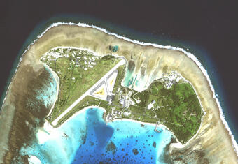
The study took place on Roi-Namur Island in the western Pacific Ocean, part of Kwajalein Atoll in the Republic of the Marshall Islands. The atoll is home to the Reagan Test Site (PDF), a multi-billion-dollar facility used to track satellites, ballistic missiles, and missile defense systems.
The researchers focused on forecasting “tipping points” - when the combination of sea-level rise, storm wave-driven overwash, and reduced rainfall becomes so frequent that existing buildings, fresh water sources, and other infrastructure become unsustainable. Since 1990, sea level in the western Pacific Ocean has risen two to three times faster than the global average. Adding storm waves means flooding on atoll islands could be worse and happen sooner. And climate change forecasts call for slightly reduced rainfall on the islands, making the fresh water problem even more challenging.
The tipping point when natural fresh groundwater on Roi-Namur and adjacent islands will be unavailable could arrive before 2035 for the worst-case climate scenario. On top of that, most of Roi-Namur’s land could flood with seawater every year starting around 2060–another tipping point. And the tipping point for drinkable groundwater on most low-lying atoll islands world-wide could occur as early as the 2030s.

The Defense Department chose three widely-accepted climate change and sea-level rise scenarios for the study. The first, based on reduced greenhouse gas emissions by mid-century, is known as RCP4.5. RCP8.5 assumes “business as usual” growth in carbon emissions. The third adds polar ice sheet collapse to RCP8.5 to create a worst-case scenario.

Congress cited early results from this study in the National Defense Authorization Act for Fiscal Year 2018: “In the Marshall Islands, an Air Force radar installation built on an atoll at a cost of \$1,000,000,000 is projected to be underwater within two decades.” Previous research showed that similar problems face other low-lying Pacific islands, including Laysan Island and Midway Atoll (see “Many Atolls May be Uninhabitable Within Decades Due to Climate Change”).
“We’re working with the Defense Department on detailed follow-up studies to characterize the problems for defense sites on other islands,” said Storlazzi, “and potentially develop a real-time coastal flood impact warning system.”
The full report, titled “The Impact of Sea-Level Rise and Climate Change on Department of Defense Installations on Atolls in the Pacific Ocean (RC-2334),” may be downloaded from the Defense Department. The USGS Pacific Coastal and Marine Science Center web site has more information about this ongoing research project.

Related
Learn more about our related science projects.

Low-lying areas of tropical Pacific islands

The Impact of Sea-Level Rise and Climate Change on Pacific Ocean Atolls

Coral Reef Project: Kwajalein Island

Coral Reef Project: Roi-Namur Island
Related
Learn more about our related science projects.
Low-lying areas of tropical Pacific islands
The Impact of Sea-Level Rise and Climate Change on Pacific Ocean Atolls
Coral Reef Project: Kwajalein Island