Low-flying helicopter to survey the Coalinga and Pyramid Hills areas for groundwater research
Note to Editors: In the public interest and in accordance with FAA regulations, the USGS is announcing this low-level airborne project. Your assistance informing the local communities is appreciated.
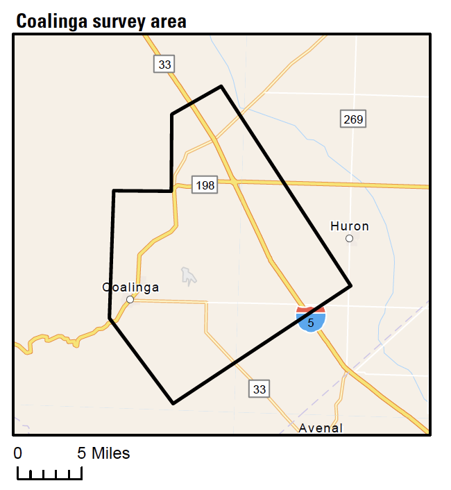
COALINGA, Calif. – Starting around November 17, 2022 and lasting up to a month, a helicopter towing a large hoop from a cable will make low-level flights over areas of the western San Joaquin Valley in Fresno, Kings, and Kern Counties near Coalinga and the Pyramid Hills, with limited surveying near Lost Hills. Residents of these areas may see a low-flying helicopter towing a large hoop hanging from a cable.
USGS scientists will use the data to improve understanding of groundwater salinity and below-ground geology to better understand groundwater conditions near California’s oil fields.
The helicopter will tow a sensor that resembles a large hula-hoop about 100-200 feet above the ground to measure small electromagnetic signals. These signals can be used to map geologic features, like aquifers, below Earth’s surface. The scientific instruments carried by the aircraft do not pose a health risk to people or animals.
The USGS study will be conducted by the specialty airborne geophysical survey company SkyTEM ApS, under a USGS contract with Woolpert. The helicopter will be operated by experienced pilots from Paso Robles based Sinton Helicopters, who are trained for the low-level flying required for geophysical surveys. The company works with the FAA to ensure flights are safe and in accordance with U.S. law. The surveys will be conducted during daylight hours only. Surveys do not occur over populated areas and the helicopter will not directly overfly buildings at low altitude.
Once the survey is complete, USGS scientists will review and process the geophysical data. The datasets will be used together with existing groundwater measurements to better understand groundwater salinity and the shape of the shallow aquifers across the study area. All results and data will be made available to the public at no cost.
USGS-led studies have recently used this type of aerial survey to inform groundwater investigations around the country, including in California. By using cutting-edge airborne geophysical technology, USGS scientists efficiently obtain critical, high-resolution information about groundwater resources over large areas, without the need for intensive ground-based work.
This survey is a continuation of groundwater salinity and aquifer mapping efforts conducted in 2016, 2017, and 2018 near Lost Hills, Buttonwillow, Maricopa, and Cawelo.
This work is part of the U.S. Geological Survey California Oil, Gas, and Groundwater Program and the California State Water Resources Control Board Oil and Gas Regional Monitoring Program.
The maps below show the areas where airborne geophysical surveys are planned.


