
Stylized animation showing the shoreline of a wetland that is eroded by waves or currents eating away the sediment along the edge of the wetland. The displaced sediment is then deposited back onto the wetland platform by other waves. When this process happens continually, layers of displaced sediment build up over time, raising the surface of the wetland.
Celebrating American Wetlands Month with USGS Wetland Science
This May, we celebrate our Nation's wonderful wetlands
This May, we celebrate our Nation's wonderful wetlands
By Wetland and Aquatic Research Center
May 19, 2026
This month we’re recognizing American Wetlands Month by sharing the important wetland science the USGS Wetland and Aquatic Research Center (WARC) provides to partners along the Gulf Coast, throughout America, and around the world.
What is a wetland?
What is a wetland?
It’s easy to think that a wetland is simply land…. that is wet. But it's more nuanced than that. A wetland consists of land covered by water - either at or near the surface of the soil – for part of if not the whole year. The amount of water present on these lands helps determine soil conditions and the types of plant and animal communities living in the ecosystem.
Sources/Usage: Public Domain. View Media Details
What are common characteristics of a wetland?
What are common characteristics of a wetland?
A wetland can typically be identified as such by the presence of characteristic environments related to water, soil, and aquatic plants.
Water is a critical component in every wetland habitat. In a wetland, soil is either saturated or covered by shallow water for at least part of the year. The quantity and seasonality of water presence helps determine wetland types.
Hydric soil is saturated by water for part of, if not the whole, year, this leads to anaerobic conditions that support the growth of vegetation tolerant of low-oxygen environments.
Aquatic plants known as hydrophytic vegetation are adapted to grow in anaerobic soils resulting from soils being permanent or seasonally saturated.
But...no wetland is the same.
Each wetland varies in its hydrology, plant community composition, soil types, biogeochemical processes, climate, among other environmental factors. They can be different sizes and may be freshwater or saltwater ecosystems. Examples of wetlands studied by scientists at the USGS WARC include salt marshes, bald cypress swamps, and mangrove forests.
")


Where are wetlands found?
Where are wetlands found?
Wetlands occur most anywhere, including every continent besides Antarctica - as long as there is a source of water available, whether it is groundwater or a nearby water body. In the United States, wetlands are found in every state, even Alaska and Hawaii.
Sources/Usage: Public Domain. View Media Details

Media

Sources/Usage: Some content may have restrictions. View Media Details
What is threatening wetland ecosystems?
Despite their obvious importance, wetlands have experienced degradation and loss from threats like hydrological alteration – via levees and dams, for example - sea-level rise, coastal development, pollution, and even invasive species.
A ghost forest in tidal freshwater forested wetlands of the Sampit River, South Carolina. USGS scientists are investigating the conversion of tidal freshwater forested wetlands - found where freshwater watersheds and estuaries meet - to “Ghost Forests” which result from rising sea levels, salt water intrusion into freshwater wetland habitats, and human activities, like coastal development. Using a large-scale, integrated approach, USGS scientists are studying how these factors affect the ecosystem’s resiliency and capacity for carbon storage, among other ecosystem services. Ultimately, this information will guide decision-making related to wetland restoration, coastal resilience, and carbon sequestration.
Why are wetlands important?
Why are wetlands important?
Wetlands are one of the most productive ecosystems on our planet, comparable to rain forests and coral reefs. Often, these serve as a transition zone between land and water, and are important for ecological, economic, and cultural reasons. Wetlands provide habitat to birds, fishes, and other wildlife; buffer coastlines from storms and flooding events; help prevent erosion; and improve water quality by acting as a filtration system. These ecosystems provide recreational opportunities like hiking, kayaking, and bird watching. They also support fisheries and shellfish industries, particularly along the Gulf Coast.
Sources/Usage: Public Domain. View Media Details

Wetland Science at WARC
Wetland Science at WARC
Scientists at the USGS WARC investigate wetland structure and function, assess how the benefits these ecosystems provide could be affected by environmental change and human activities, and help inform wetland restoration efforts in key areas, including the Gulf Coast, the Greater Everglades in Florida, and the Mississippi River Alluvial Valley. WARC also provides critical scientific information on the important fish and wildlife species that rely on healthy wetlands for survival.
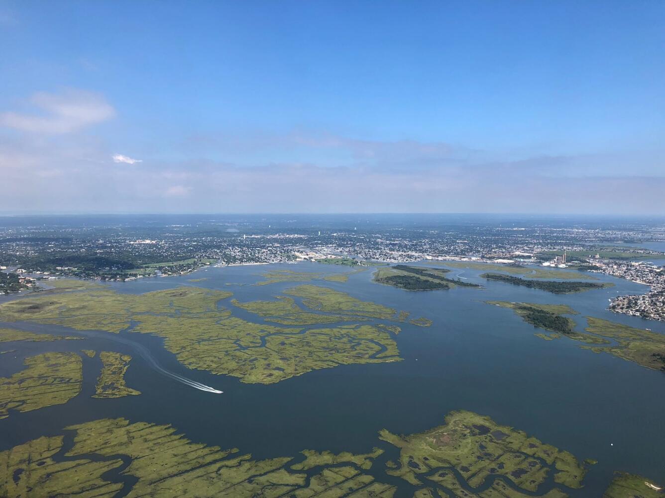
Mapping Land Area Change in Louisiana
Mapping Land Area Change in Louisiana
Louisiana has lost more than a quarter of its coastal wetlands, an area about the size of Delaware, since the 1930s. Changes to the Mississippi River and its ability to carry sediment downstream to the Gulf, coupled with sea-level rise, hurricanes, and land subsidence have contributed to the disappearance of these important ecosystems. USGS WARC scientists use historical surveys and aerial and satellite data to monitor the occurrence and rates of wetland change. By quantifying land area change over time, USGS WARC researchers are able to document and assess the short- and long-term effects of natural and anthropogenic factors on coastal wetland loss.
Media

Sources/Usage: Some content may have restrictions. View Media Details
Sources/Usage: Public Domain. View Media Details
Media

Sources/Usage: Some content may have restrictions. View Media Details
Supporting Restoration Decision Making in the Greater Everglades
One of the largest hydrologic restoration efforts in U.S. history is underway in the Florida Everglades. Starting in the 1880s, extensive agricultural, residential, and commercial development throughout southern Florida disrupted habitat connectivity and water flow and availability to humans and the environment. USGS WARC science informs current restoration projects which aim to help restore the hydrologic flow while balancing the water needs of humans and the Greater Everglades ecosystems. Ecological models are one tool managers can use to evaluate and assess the various restoration strategies. The Joint Ecosystem Modeling (JEM) program, based at USGS WARC, is a partnership among federal and state agencies, universities, and other organizations which continuously develops and applies ecological models and other decision support tools to Greater Everglades restoration project planning. The JEM Sparrow Helper, as an example, helps users understand the impacts of proposed water management scenarios on the Cape Sable seaside sparrow, a federally protected bird species endemic to southern Florida.
Monitoring Coastal Wetland Restoration Projects
Monitoring Coastal Wetland Restoration Projects
To help address the loss of coastal wetlands, federal- and state-funded restoration projects have been implemented across the Louisiana coast. The Coastwide Reference and Monitoring System (CRMS) helps monitor and evaluate almost 400 projects, ranging from sediment diversions to shoreline protection to hydrologic restoration. Considered the world’s largest coastal monitoring program with publicly available data, CRMS is jointly implemented by the state of Louisiana, via the Coastal Protection and Restoration Authority, and the USGS. Scientists from USGS WARC use standardized techniques to collect information about hydrology, soil, vegetation, and land change at 45 of the sites. They also manage the database, analyze data, and ensure the data is available on the publicly accessible website. Long-term, standardized data collection helps evaluate the effectiveness of a restoration project and ensure informed decision-making when it comes to the development and implementation of future restoration projects.
Sources/Usage: Public Domain. View Media Details

Monitoring Lower Trophic Level Organisms to Support Restoration in Barataria Estuary
Monitoring Lower Trophic Level Organisms to Support Restoration in Barataria Estuary
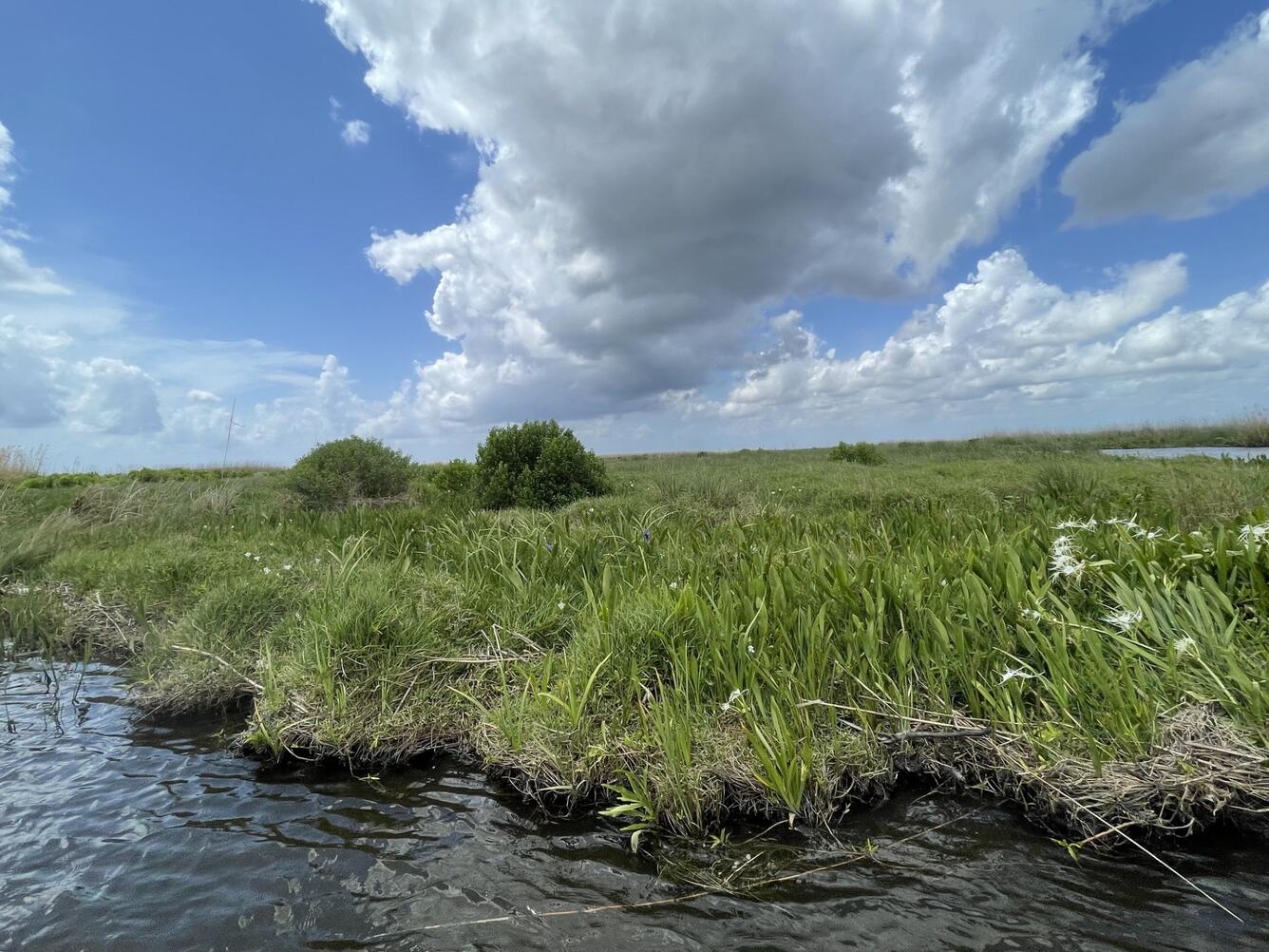
Phytoplankton, microphytobenthos, zooplankton, and benthic infauna are lower trophic level organisms that form the base of the estuarine food web. They are important food sources for juvenile fish, crabs, and shrimp that contribute to culturally and commercially important natural resources, including fisheries. They help to break down detritus, oxygenate sediments, and maintain healthy levels of nutrients in sediments. Organisms that live in the sediment also serve as excellent biological indicators of environmental conditions, including ecological recovery and ongoing impacts of buried Deepwater Horizon oil.
In Barataria Estuary, Louisiana, the food web is truncated and dominated by lower trophic level organisms such as primary producers (trophic level 1) of phytoplankton and microphytobenthos that are often consumed by zooplankton and benthic macroinfauna (trophic level 2). However, the lack of spatiotemporal information about these resources produces uncertainty about how they may change in the future.
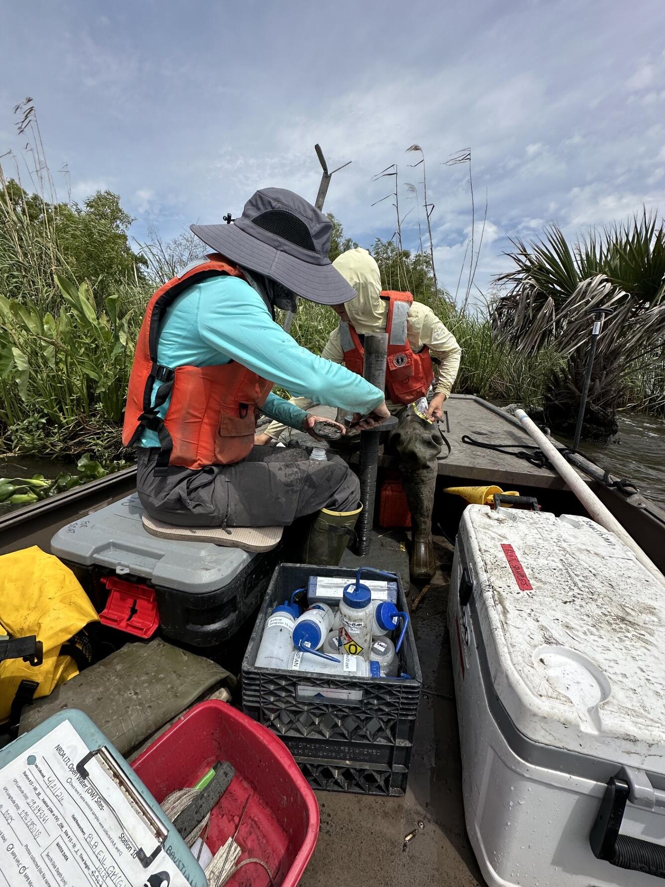
To address this, researchers at WARC are conducting field sampling of microphytobenthos and will conduct associated laboratory analyses of pigments, cell density, phytoplankton pigments, and associated physical water quality. They will synthesize lower trophic level data and produce a summary report characterizing lower trophic level conditions. This work will aid in the development of long-term lower trophic level monitoring plan for the Estuary.
Sources/Usage: Public Domain. View Media Details
Wetland Science Resources
Wetland Science Resources
Dive deeper into USGS WARC wetland science and educational resources!
Listen: Science in the Swamp
Listen: Science in the Swamp
Learn: I am a Wetland Ecologist
Related
Filter Total Items: 31

Spatial Analysis Support for Coastal Wetlands Planning, Protection and Restoration Act (Breaux Bill) Planning Activities
WARC first implemented geographic information systems (GIS) in 1980 to help monitor the nature and extent of wetland habitat changes. The center continues to use GIS, remote sensing, and other computer based technologies to address a wide range of natural resource related issues.

Spatial Analysis of Coastal Wetlands Planning, Protection and Restoration Act Projects
As the first federally mandated restoration program, Louisiana enacted the Coastal Wetlands Planning, Protection and Restoration Act (CWPPRA) to address Louisiana’s land loss crisis.

Barriers and Opportunities for Landward Migration of Coastal Wetlands along Texas' Upper and Middle Coast
Researchers at WARC will use data and models to produce probabilistic maps of current and future wetland inundation, coastal wetland extent, and coastal and wetland trangression.

Coastal Wetland Vulnerability to Climate Change and Sea-Level Rise: Understanding Ecological Thresholds and Ecosystem Transformations
Eighteen USGS coastal scientists from all four coasts of the conterminous United States are working together to advance the understanding of climate change and sea-level rise impacts to coastal wetlands.
By
California Water Science Center, Chesapeake Bay Activities, Eastern Ecological Science Center, Florence Bascom Geoscience Center, Great Lakes Science Center, Pacific Coastal and Marine Science Center, St. Petersburg Coastal and Marine Science Center, Western Ecological Research Center (WERC), Western Geographic Science Center, Wetland and Aquatic Research Center , Woods Hole Coastal and Marine Science Center

Lower Trophic Level Monitoring to Support Restoration of Living Resources in Barataria Estuary, Louisiana
USGS researchers are collecting information about lower trophic levels in Barataria Estuary to develop a long-term monitoring plan.

Quantifying Restoration Impacts on Wetland Ecosystem Health and Carbon Export
USGS is investigating the impact of restoration on Louisiana's coastal wetlands' carbon dynamics.

Decision Support Tools for Everglades Ecosystem-Based Management
The USGS Joint Ecosystem Modeling team will work with partners to identify and develop decision support tools for Everglades water management.

Multi-year Burmese Python Vital Rate Research Collaborative in the Greater Everglades
USGS researchers will track juvenile Burmese python within Big Cypress National Preserve (BICY) and collect data on snake growth, habitat use, and causes of mortality. Known-fate models will be used to estimate survival and better understand factors that influence survival.

Ecological Model Support for the Biscayne Bay and Southeastern Everglades Restoration Project
The Joint Ecosystem Modeling team will provide model output for a suite of ecological models to aid in restoration decision planning for the Biscayne Bay and Southeastern Everglades Restoration Project.

Ecological Modeling for the Central Everglades Planning Project (CEPP) Operational Plan
The Joint Ecosystem Modeling team will run a suite of 13 ecological models to provide insight into alternative restoration plans' ecological performance, unintended ecological conditions, and potential conflicts with other Comprehensive Everglades Restoration Plan (CERP) goals.

Decision Support Tool to Assess the Carbon Sequestration Potential of Restoring Wetlands within National Park Service Lands
USGS is developing a modeling tool that will let National Park Service assess the carbon sequestration potential of future wetland restoration projects.

Developing a Decision Support Tool to Assess Carbon Sequestration on Natural Resource Conservation Service’s Wetland Reserve Easements in Kentucky and Tennessee
USGS is developing a decision support tool to help managers quantify the impact of wetland restoration on carbon sequestration in wetland reserve easements in Kentucky and Tennessee.

Elevation Gain | Wetland Loss
Stylized animation showing the shoreline of a wetland that is eroded by waves or currents eating away the sediment along the edge of the wetland. The displaced sediment is then deposited back onto the wetland platform by other waves. When this process happens continually, layers of displaced sediment build up over time, raising the surface of the wetland.

Coastal Wetlands
Coastal wetlands are among the most productive and valuable ecosystems in the world—comparable to even rainforests and coral reefs.
Coastal wetlands are among the most productive and valuable ecosystems in the world—comparable to even rainforests and coral reefs.

I Am A...Wetland Ecologist
Welcome to the “I Am A..." series, a whiteboard animation video series highlighting USGS careers.
Welcome to the “I Am A..." series, a whiteboard animation video series highlighting USGS careers.

Wade into Wetlands Research
Slideshow of images related to USGS wetlands research.
By
Slideshow of images related to USGS wetlands research.
By
Related
Filter Total Items: 31
Spatial Analysis Support for Coastal Wetlands Planning, Protection and Restoration Act (Breaux Bill) Planning Activities
WARC first implemented geographic information systems (GIS) in 1980 to help monitor the nature and extent of wetland habitat changes. The center continues to use GIS, remote sensing, and other computer based technologies to address a wide range of natural resource related issues.
Spatial Analysis of Coastal Wetlands Planning, Protection and Restoration Act Projects
As the first federally mandated restoration program, Louisiana enacted the Coastal Wetlands Planning, Protection and Restoration Act (CWPPRA) to address Louisiana’s land loss crisis.
Barriers and Opportunities for Landward Migration of Coastal Wetlands along Texas' Upper and Middle Coast
Researchers at WARC will use data and models to produce probabilistic maps of current and future wetland inundation, coastal wetland extent, and coastal and wetland trangression.
Coastal Wetland Vulnerability to Climate Change and Sea-Level Rise: Understanding Ecological Thresholds and Ecosystem Transformations
Eighteen USGS coastal scientists from all four coasts of the conterminous United States are working together to advance the understanding of climate change and sea-level rise impacts to coastal wetlands.
By
California Water Science Center, Chesapeake Bay Activities, Eastern Ecological Science Center, Florence Bascom Geoscience Center, Great Lakes Science Center, Pacific Coastal and Marine Science Center, St. Petersburg Coastal and Marine Science Center, Western Ecological Research Center (WERC), Western Geographic Science Center, Wetland and Aquatic Research Center , Woods Hole Coastal and Marine Science Center
Lower Trophic Level Monitoring to Support Restoration of Living Resources in Barataria Estuary, Louisiana
USGS researchers are collecting information about lower trophic levels in Barataria Estuary to develop a long-term monitoring plan.
Quantifying Restoration Impacts on Wetland Ecosystem Health and Carbon Export
USGS is investigating the impact of restoration on Louisiana's coastal wetlands' carbon dynamics.
Decision Support Tools for Everglades Ecosystem-Based Management
The USGS Joint Ecosystem Modeling team will work with partners to identify and develop decision support tools for Everglades water management.
Multi-year Burmese Python Vital Rate Research Collaborative in the Greater Everglades
USGS researchers will track juvenile Burmese python within Big Cypress National Preserve (BICY) and collect data on snake growth, habitat use, and causes of mortality. Known-fate models will be used to estimate survival and better understand factors that influence survival.
Ecological Model Support for the Biscayne Bay and Southeastern Everglades Restoration Project
The Joint Ecosystem Modeling team will provide model output for a suite of ecological models to aid in restoration decision planning for the Biscayne Bay and Southeastern Everglades Restoration Project.
Ecological Modeling for the Central Everglades Planning Project (CEPP) Operational Plan
The Joint Ecosystem Modeling team will run a suite of 13 ecological models to provide insight into alternative restoration plans' ecological performance, unintended ecological conditions, and potential conflicts with other Comprehensive Everglades Restoration Plan (CERP) goals.
Decision Support Tool to Assess the Carbon Sequestration Potential of Restoring Wetlands within National Park Service Lands
USGS is developing a modeling tool that will let National Park Service assess the carbon sequestration potential of future wetland restoration projects.
Developing a Decision Support Tool to Assess Carbon Sequestration on Natural Resource Conservation Service’s Wetland Reserve Easements in Kentucky and Tennessee
USGS is developing a decision support tool to help managers quantify the impact of wetland restoration on carbon sequestration in wetland reserve easements in Kentucky and Tennessee.
Elevation Gain | Wetland Loss
Stylized animation showing the shoreline of a wetland that is eroded by waves or currents eating away the sediment along the edge of the wetland. The displaced sediment is then deposited back onto the wetland platform by other waves. When this process happens continually, layers of displaced sediment build up over time, raising the surface of the wetland.
Stylized animation showing the shoreline of a wetland that is eroded by waves or currents eating away the sediment along the edge of the wetland. The displaced sediment is then deposited back onto the wetland platform by other waves. When this process happens continually, layers of displaced sediment build up over time, raising the surface of the wetland.
Coastal Wetlands
Coastal wetlands are among the most productive and valuable ecosystems in the world—comparable to even rainforests and coral reefs.
Coastal wetlands are among the most productive and valuable ecosystems in the world—comparable to even rainforests and coral reefs.
I Am A...Wetland Ecologist
Welcome to the “I Am A..." series, a whiteboard animation video series highlighting USGS careers.
Welcome to the “I Am A..." series, a whiteboard animation video series highlighting USGS careers.
Wade into Wetlands Research
Slideshow of images related to USGS wetlands research.
By
Slideshow of images related to USGS wetlands research.
By