
The May 18, 1980 eruption of Mount St. Helens had a dramatic impact on the North Fork Toutle River. The debris avalanche, lateral blast and ashfall produced a substantial amount of sediment, which continues to be washed into the river and transported downstream.
Images
Images related to Cascades Volcano Observatory.
Filter Total Items: 415

North Fork Toutle River, Sediment Retention Struct., Mount St. Helens
The May 18, 1980 eruption of Mount St. Helens had a dramatic impact on the North Fork Toutle River. The debris avalanche, lateral blast and ashfall produced a substantial amount of sediment, which continues to be washed into the river and transported downstream.

Mapping the North Fork Toutle River using a terrestrial laser scann...
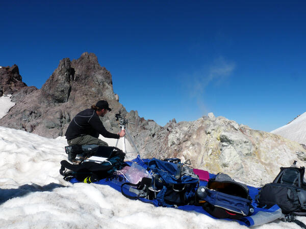
The USGS, in collaboration with UNAVCO and the University of Colorado, uses these data to measure channel erosion and deposition in the reach.
The USGS, in collaboration with UNAVCO and the University of Colorado, uses these data to measure channel erosion and deposition in the reach.
USGS geologist uses a UV spectrometer to detect gases from a fumarole
USGS geologist uses a UV spectrometer to detect gases from fumarole at Crater Rock, Mount Hood.
USGS geologist uses a UV spectrometer to detect gases from fumarole at Crater Rock, Mount Hood.

Water depth measurements at Spirit Lake, Mount St. Helens, using ac...
Back at the USGS Cascades Volcano Observatory office, these data are merged with airborne LiDAR data to calculate lake volume.
Back at the USGS Cascades Volcano Observatory office, these data are merged with airborne LiDAR data to calculate lake volume.

Rime ice coats telemetry station north of Mount St. Helens, WA
Volcano monitoring stations must be designed to withstand harsh winter conditions.
Volcano monitoring stations must be designed to withstand harsh winter conditions.

Mount Rainier rises above Tacoma, WA and boat harbor, which may be ...
Mount Rainier rises above Tacoma, Washington and boat harbor, which may be impacted during the next eruption of the volcano.
Mount Rainier rises above Tacoma, Washington and boat harbor, which may be impacted during the next eruption of the volcano.

Extent of Newberry lavas including approximate ages of surficial flows
Extending approximately 75 miles north to south and 27 miles east to west, Newberry Volcano and its broad apron of lavas (light yellow shaded area) cover a total area of almost 1,200 square miles, making it the largest volcano of the Cascades volcanic chain. Its lavas stretch north beyond Smith Rock State Park, and south almost to Fort Rock State Natural Area.
Extending approximately 75 miles north to south and 27 miles east to west, Newberry Volcano and its broad apron of lavas (light yellow shaded area) cover a total area of almost 1,200 square miles, making it the largest volcano of the Cascades volcanic chain. Its lavas stretch north beyond Smith Rock State Park, and south almost to Fort Rock State Natural Area.

Stream channel cross-section measurements—instrument that uses lase...
Stream channel cross-section measurements—instrument that uses laser pulses to survey distance to a reflector operated by a second crew member, Mount St. Helens.
Stream channel cross-section measurements—instrument that uses laser pulses to survey distance to a reflector operated by a second crew member, Mount St. Helens.
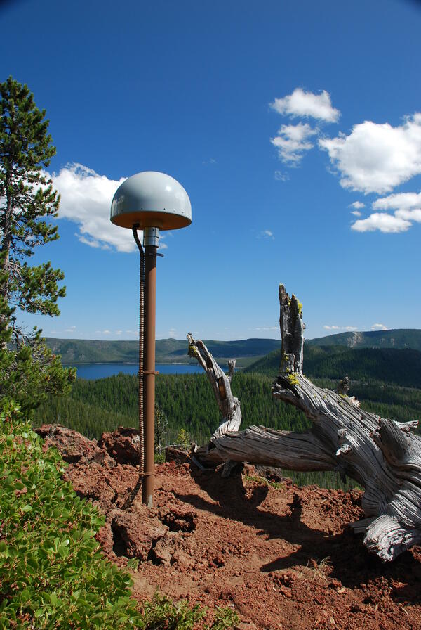
Global Positioning System receiver (called a GPS monument) at North...
Global Positioning System receiver (called a GPS monument) at North Rim Station, a monitoring location at Newberry volcano, Oregon.
Global Positioning System receiver (called a GPS monument) at North Rim Station, a monitoring location at Newberry volcano, Oregon.

Newberry caldera with Paulina Peak, Big Obsidian Flow and Paulina Lake
View looking south across Newberry caldera towards the Big Obsidian flow (left of center) and Paulina Peak, with Paulina Lake in foreground. Photo taken from the north rim of the caldera.
View looking south across Newberry caldera towards the Big Obsidian flow (left of center) and Paulina Peak, with Paulina Lake in foreground. Photo taken from the north rim of the caldera.

Gas sampling with CO2 Infrared Spectrometer at Mount St. Helens
Gas sampling with a CO2 Infrared Spectrometer at Mount St. Helens' September Lobe lava dome, Washington.
Gas sampling with a CO2 Infrared Spectrometer at Mount St. Helens' September Lobe lava dome, Washington.

Mt. St. Helens viewed at sunset
View of Mt. St. Helens at sunset, taken sometime after the crater forming eruption in 1980.
View of Mt. St. Helens at sunset, taken sometime after the crater forming eruption in 1980.
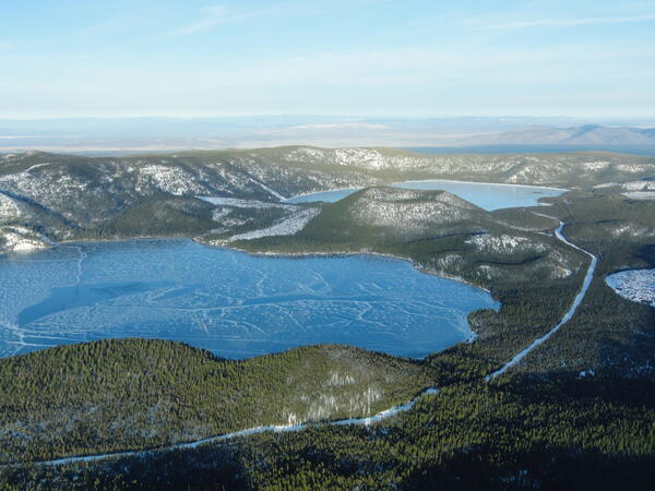
Aerial view of lakes and cinder cone at Newberry Volcano Caldera.
A view looking northeast across the central caldera of Newberry Volcano. Paulina Lake is in the foreground and East Lake is in the distance. The Central Pumice Cone lies between the two lakes. Near the bottom of the photo at the south edge of Paulina Lake, the two hills are named the Lakeshore Domes.
A view looking northeast across the central caldera of Newberry Volcano. Paulina Lake is in the foreground and East Lake is in the distance. The Central Pumice Cone lies between the two lakes. Near the bottom of the photo at the south edge of Paulina Lake, the two hills are named the Lakeshore Domes.

Mount Baker's NEern face, WA.
Mount Baker's northeastern face, Washington.
Mount Baker's northeastern face, Washington.

Suspended sediment sample collection from the North Fork Toutle Riv...
Suspended sediment sample collection from the North Fork Toutle River above the Sediment Retention Structure, downstream from Mount St. Helens.
Suspended sediment sample collection from the North Fork Toutle River above the Sediment Retention Structure, downstream from Mount St. Helens.

Mount St. Helens, as viewed from Coldwater Ridge around sunset.
Mount St. Helens, as viewed from Coldwater Ridge around sunset.
Mount St. Helens, as viewed from Coldwater Ridge around sunset.

Seismic station VALT in Mount St. Helens crater, view toward the south
Seismic station VALT in Mount St. Helens crater, view toward the south.
Seismic station VALT in Mount St. Helens crater, view toward the south.

Lake elevation monitoring gage on Spirit Lake, Mount St. Helens. Do...
The USGS operates a real-time lake elevation monitoring gage on Spirit Lake to ensure water level does not exceed a safe limit. In 1985, the U.S.
The USGS operates a real-time lake elevation monitoring gage on Spirit Lake to ensure water level does not exceed a safe limit. In 1985, the U.S.

Helicopter dropping off monitoring equipment at Mount St. Helens, WA.
Helicopter dropping off monitoring equipment at Mount St. Helens, Washington.
Helicopter dropping off monitoring equipment at Mount St. Helens, Washington.

Eruptions in the Cascade Range during the past 4000 years. USGS GIP 64
Eruptions in the Cascade Range during the past 4000 years. USGS GIP 64
Eruptions in the Cascade Range during the past 4000 years. USGS GIP 64

Sun Creek Valley with Crater Lake in background, aerial view lookin...
Morning aerial view looking northwest up the valley of Sun Creek. Applegate Peak caps the prominent rock wall of the west side of Sun Notch at the caldera rim. Northwest caldera wall is visible on opposite side of Crater Lake through Sun Notch. Grayback Ridge in foreground is thick lava of pre-Mazama rhyodacite (410-460 ka).
Morning aerial view looking northwest up the valley of Sun Creek. Applegate Peak caps the prominent rock wall of the west side of Sun Notch at the caldera rim. Northwest caldera wall is visible on opposite side of Crater Lake through Sun Notch. Grayback Ridge in foreground is thick lava of pre-Mazama rhyodacite (410-460 ka).