U.S. flag

An official website of the United States government

Multimedia

Webcams—Near-real-time images from webcams.

Videos—Collection of videos recorded during field excursions or caught on our webcams.

Image Galleries—Galleries of images and events with expanded descriptions.

The Kīlauea Photo and Video Chronology and Mauna Loa Photo and Video Chronology webpages also feature photos. 

Images

Color photograph of lava fountain and lava flow
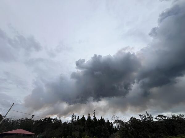
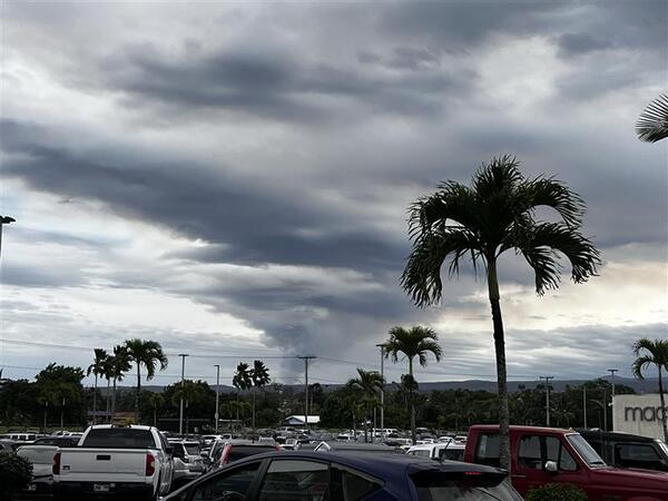
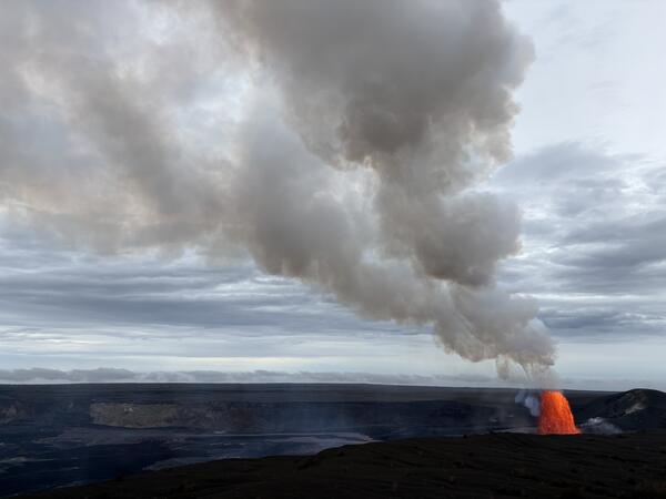
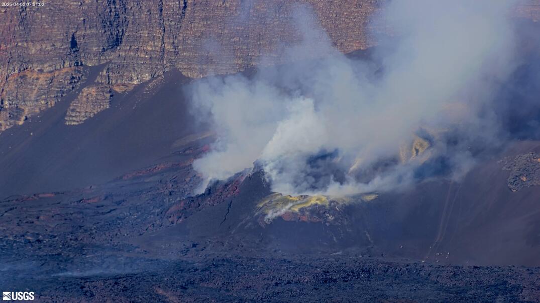
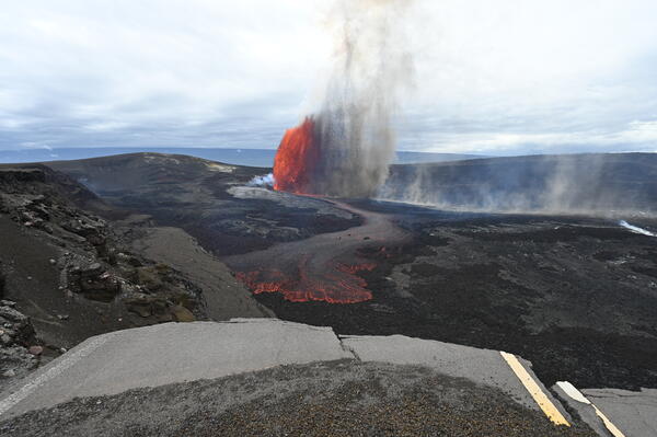
April 9, 2026 — Kīlauea summit eruption episode 44

Episode 44 of lava fountaining in Halemaʻumaʻu began at the summit of Kīlauea began at 11:10 a.m. HST on April 9, 2026. Precursory lava flows began on April 3, primarily from the south vent, and continued intermittently until the episode began. The predominant lava fountain during episode 44, however, came from the north vent.

Episode 44 of lava fountaining in Halemaʻumaʻu began at the summit of Kīlauea began at 11:10 a.m. HST on April 9, 2026. Precursory lava flows began on April 3, primarily from the south vent, and continued intermittently until the episode began. The predominant lava fountain during episode 44, however, came from the north vent.

Color photograph of eruptive plume
April 9, 2026 — Kīlauea episode 44 eruptive plume from Volcano village

The eruptive plume associated with episode 44 of lava fountaining at the summit of Kīlauea was transported by wind in a northeast direction. This photo shows the plume from Volcano village, about 4 miles (6.5 km) northeast of the eruptive vents in Hawaiʻi Volcanoes National Park. USGS photo by P. Dotray. 

The eruptive plume associated with episode 44 of lava fountaining at the summit of Kīlauea was transported by wind in a northeast direction. This photo shows the plume from Volcano village, about 4 miles (6.5 km) northeast of the eruptive vents in Hawaiʻi Volcanoes National Park. USGS photo by P. Dotray. 

Color photograph of volcanic plume
April 9, 2026 — Kīlauea episode 44 eruption plume from Hilo

Episode 44 at the summit of Kīlauea generated a plume of ash and gas, which strong southerly winds transported in a narrow band to the north-northeast of Halemaʻumaʻu, where it widened over a large section of east Hawaiʻi. This photo shows the eruption plume from Hilo, about 25 miles (40 km) to the northeast of the eruptive vents. USGS photo by C.

Episode 44 at the summit of Kīlauea generated a plume of ash and gas, which strong southerly winds transported in a narrow band to the north-northeast of Halemaʻumaʻu, where it widened over a large section of east Hawaiʻi. This photo shows the eruption plume from Hilo, about 25 miles (40 km) to the northeast of the eruptive vents. USGS photo by C.

Color photograph of road covered with volcanic fallout
April 9, 2026 — Kīlauea episode 44 tephra on Crater Rim Drive

Crater Rim Drive near Kilauea Military Camp in Hawaiʻi Volcanoes National Park was covered with tephra from episode 44 lava fountaining at the summit of Kīlauea on April 9, 2026. This photo shows recent tire tracks in the newly deposited tephra. USGS photo by K. Mulliken.

Crater Rim Drive near Kilauea Military Camp in Hawaiʻi Volcanoes National Park was covered with tephra from episode 44 lava fountaining at the summit of Kīlauea on April 9, 2026. This photo shows recent tire tracks in the newly deposited tephra. USGS photo by K. Mulliken.

Color photograph of geologist walking road covered with volcanic fallout
April 9, 2026 — Episode 44 tephra on Crater Rim Drive near Steaming Bluff

During lava fountaining episode 44 at the summit of Kīlauea, winds transported gas and tephra in a narrow band to the north-northeast of Halemaʻumaʻu. Tephra fallout was strongest in the direction of Kilauea Military Camp and the Volcano Golf Course subdivision, with pieces of lightweight reticulite up to 12 inches (30 centimeters) reported falling in these areas.

During lava fountaining episode 44 at the summit of Kīlauea, winds transported gas and tephra in a narrow band to the north-northeast of Halemaʻumaʻu. Tephra fallout was strongest in the direction of Kilauea Military Camp and the Volcano Golf Course subdivision, with pieces of lightweight reticulite up to 12 inches (30 centimeters) reported falling in these areas.

Color photograph of lava fountain and plume
April 9, 2026 — Episode 44 lava fountaining from Uēkahuna

This photograph, taken from the north rim of Kaluapele (Kīlauea caldera) near Uēkahuna around 4 p.m. HST on April 9, 2026, shows the lava fountain from the north vent rising above the crater walls during episode 44. USGS photo by D. Downs. 

This photograph, taken from the north rim of Kaluapele (Kīlauea caldera) near Uēkahuna around 4 p.m. HST on April 9, 2026, shows the lava fountain from the north vent rising above the crater walls during episode 44. USGS photo by D. Downs. 

Videos

Color photograph of lava fountain Color photograph of lava fountain
April 9, 2026 — VIDEO: Episode 44 lava fountaining at the summit of Kīlauea

Views of lava fountaining episode 44 at the summit of Kīlauea on April 9, 2026. USGS videos by M. Patrick, L. Gallant, and D. Downs. 

Color photograph of lava fountain Color photograph of lava fountain
March 10, 2026 — Video of Kīlauea episode 43 lava fountaining

This video shows activity during the episode 43 lava fountains at the summit of Kīlauea. The video was taken from the south rim, which provided clear views of the north and south fountains, and the lava channels that transported lava from the vent into the eastern portion of the crater floor. USGS photo by M. Patrick.

This video shows activity during the episode 43 lava fountains at the summit of Kīlauea. The video was taken from the south rim, which provided clear views of the north and south fountains, and the lava channels that transported lava from the vent into the eastern portion of the crater floor. USGS photo by M. Patrick.

Color photograph of misty volcanic crater Color photograph of misty volcanic crater
February 26, 2026 — Video of Halemaʻumaʻu crater overflight, Kīlauea summit

USGS Hawaiian Volcano Observatory (HVO) geologists on a routine Kīlauea summit monitoring helicopter overflight on Thursday, February 26, collected visual and thermal images to map out the changes on the crater floor following episode 42 lava fountaining at Kīlauea summit that took place on February 15, 2026.

USGS Hawaiian Volcano Observatory (HVO) geologists on a routine Kīlauea summit monitoring helicopter overflight on Thursday, February 26, collected visual and thermal images to map out the changes on the crater floor following episode 42 lava fountaining at Kīlauea summit that took place on February 15, 2026.

Color photograph of lava fountain feeding lava flows on the floor of a crater Color photograph of lava fountain feeding lava flows on the floor of a crater
February 15, 2026 — Timelapse video of Kīlauea episode 42 from the KWcam

The KWcam is located on the northwest rim of Halemaʻumaʻu crater at the summit of Kīlauea. The camera is one of many located around the Kaluapele, Kīlauea summit caldera, that aid in monitoring conditions. This timelapse video was created using images captured by the KWcam on February 15, 2026, during episode 42 of lava fountaining. Around 4:20 p.m.

The KWcam is located on the northwest rim of Halemaʻumaʻu crater at the summit of Kīlauea. The camera is one of many located around the Kaluapele, Kīlauea summit caldera, that aid in monitoring conditions. This timelapse video was created using images captured by the KWcam on February 15, 2026, during episode 42 of lava fountaining. Around 4:20 p.m.

Color photograph of lava fountain Color photograph of lava fountain
January 24-25, 2026 — Kīlauea episode 41 tephra fall covers Uēkahuna Overlook Hawaiʻi Volcanoes National Park and then is cleaned up

Timelapse video showing tephra cover to cleanup in Hawaiʻi Volcanoes National Park. Lava fountains during episode 41 of the Kīlauea summit eruption on January 24, 2026, covered the Uēkahuna overlook within Hawaiʻi Volcanoes National Park with tephra fallout. The next morning, Hawaiʻi Volcanoes National Park staff clean the tephra from the area.

Color photograph of lava fountain Color photograph of lava fountain
January 24, 2026 — Kīlauea episode 41 timelapse video

This timelapse video shows Kīlauea summit eruption episode 41 on January 24, 2026, captured by a USGS Hawaiian Volcano Observatory research camera on the south rim of the caldera. Both the north and south vents erupted,and the black material in the foreground is falling tephra. USGS video.


This timelapse video shows Kīlauea summit eruption episode 41 on January 24, 2026, captured by a USGS Hawaiian Volcano Observatory research camera on the south rim of the caldera. Both the north and south vents erupted,and the black material in the foreground is falling tephra. USGS video.


Audio

Kīlauea's Summit Vent Churns and Pops as Rocks Fall Into the Lava L...
Kīlauea's Summit Vent Churns and Pops as Rocks Fall Into Lava Lake
Lava lake activity from inside Halema`uma`u Crater
Kīlauea's Summit Vent Churns and Pops as Rocks Fall Into the Lava L...
Kīlauea's Summit Vent Churns and Pops as Rocks Fall Into Lava Lake
Lava lake activity from inside Halema`uma`u Crater

Sounds of lava lake activity within Kilauea Volcano's summit vent inside Halema`uma`u Crater on the afternoon of February 14, 2011. The continuous "crashing wave" noise is the sound of churning lava as gases are released from the lake surface, which is in nearly constant motion.

Sounds of lava lake activity within Kilauea Volcano's summit vent inside Halema`uma`u Crater on the afternoon of February 14, 2011. The continuous "crashing wave" noise is the sound of churning lava as gases are released from the lake surface, which is in nearly constant motion.

USGS CoreCast
USGS CoreCast Series
Dramatic Developments at Kilauea Volcano
USGS CoreCast
USGS CoreCast Series
Dramatic Developments at Kilauea Volcano

Kilauea Volcano in Hawaii has experienced its first explosive eruption in more than 80 years and is now spewing noxious gas at 10 times the normal rate. John Eichelberger, head of the USGS Volcano Hazards Program, fills us in on the situation.

Kilauea Volcano in Hawaii has experienced its first explosive eruption in more than 80 years and is now spewing noxious gas at 10 times the normal rate. John Eichelberger, head of the USGS Volcano Hazards Program, fills us in on the situation.

Webcams

webcam image of flank of volcano
[MSTcam] South Pit and Upper Southwest Rift Zone - thermal image from Moku‘āweoweo south rim
[MSTcam] South Pit and Upper Southwest Rift Zone - thermal image from Moku‘āweoweo south rim
[MSTcam] South Pit and Upper Southwest Rift Zone - thermal image from Moku‘āweoweo south rim

This image is from a research camera positioned on the south rim of Mokuʻāweoweo, Mauna Loa's summit caldera, in Hawaiʻi Volcanoes National Park. The camera looks west-southwest, across South Pit, focusing on the south part of Mauna Loa's summit region and upper Southwest Rift Zone.

This image is from a research camera positioned on the south rim of Mokuʻāweoweo, Mauna Loa's summit caldera, in Hawaiʻi Volcanoes National Park. The camera looks west-southwest, across South Pit, focusing on the south part of Mauna Loa's summit region and upper Southwest Rift Zone.

Color webcam image
[V3cam] Kīlauea volcano, Hawaii (south Halemaʻumaʻu crater)
[V3cam] Kīlauea volcano, Hawaii (south Halemaʻumaʻu crater)
[V3cam] Kīlauea volcano, Hawaii (south Halemaʻumaʻu crater)

Last 24 Hours - Live view of Halemaʻumaʻu crater within Kaluapele (Kīlauea caldera), from the south rim of the crater [V3cam]. This camera is a pan-tilt-zoom model and the view may change depending on activity.

Disclaimer

Last 24 Hours - Live view of Halemaʻumaʻu crater within Kaluapele (Kīlauea caldera), from the south rim of the crater [V3cam]. This camera is a pan-tilt-zoom model and the view may change depending on activity.

Disclaimer

Color image of caldera
[V2cam] Kīlauea volcano, Hawaii (east Halemaʻumaʻu crater)
[V2cam] Kīlauea volcano, Hawaii (east Halemaʻumaʻu crater)
[V2cam] Kīlauea volcano, Hawaii (east Halemaʻumaʻu crater)

Live view of Kaluapele (Kīlauea caldera) and Halemaʻumaʻu crater, from the northeast rim of the caldera [V2cam]. This camera is a pan-tilt-zoom model and the view may change depending on activity.

Disclaimer

Live view of Kaluapele (Kīlauea caldera) and Halemaʻumaʻu crater, from the northeast rim of the caldera [V2cam]. This camera is a pan-tilt-zoom model and the view may change depending on activity.

Disclaimer

Color image of volcano
[KOcam] Live Image of upper East Rift Zone from Maunaulu
[KOcam] Live Image of upper East Rift Zone from Maunaulu
[KOcam] Live Image of upper East Rift Zone from Maunaulu

This image is from a temporary research camera positioned near Maunaulu, looking northwest toward the upper East Rift Zone of Kīlauea.

Disclaimer

Color webcam image showing rift zone of volcano
[MDLcam] The Upper and Middle Parts of Mauna Loa's Southwest Rift Zone
[MDLcam] The Upper and Middle Parts of Mauna Loa's Southwest Rift Zone
[MDLcam] The Upper and Middle Parts of Mauna Loa's Southwest Rift Zone

Live image of Mauna Loa's upper and middle Southwest Rift Zone from Dandelion Cone along the middle part of the rift zone [MDLcam]. This camera is a pan-tilt-zoom model and the view may change depending on activity.


Disclaimer

Live image of Mauna Loa's upper and middle Southwest Rift Zone from Dandelion Cone along the middle part of the rift zone [MDLcam]. This camera is a pan-tilt-zoom model and the view may change depending on activity.


Disclaimer

Color webcam image showing flank of volcano
[MSPcam] Mauna Loa's Southwest Rift Zone from the South Point area
[MSPcam] Mauna Loa's Southwest Rift Zone from the South Point area
[MSPcam] Mauna Loa's Southwest Rift Zone from the South Point area

Live image of Mauna Loa's Southwest Rift Zone from the South Point area [MSPcam]. This camera is a pan-tilt-zoom model and the view may change depending on activity.


Disclaimer

Live image of Mauna Loa's Southwest Rift Zone from the South Point area [MSPcam]. This camera is a pan-tilt-zoom model and the view may change depending on activity.


Disclaimer

Was this page helpful?