
Photo and Video Chronology — January 2, 2025 — Vigorous lava fountaining continues at Kīlauea summit
By Hawaiian Volcano Observatory
January 2, 2025
The eruption at Kīlauea volcano that began on Monday, December 23, continues as of January 2. Over the past day, vents in the southwest portion of the caldera have continued producing a fan of lava flows covering the western portion of the crater floor during sustained lava fountaining.
Media

A view from the west rim of Kaluapele (Kīlauea summit caldera) of the vents erupting at Kīlauea summit. USGS photo by M. Patrick.
Sources/Usage: Public Domain. View Media Details
Media
A broader view of the activity at Kīlauea summit. The lava fountaining has produced a large pyroclastic cone against the western wall, with deposits draped on the walls. Lava pours out of the vents into a large ponded area in the southwest portion of Halema‘uma‘u crater. A chunk of the cone has been rafted out in the lava stream towards the east, and is visible in the lower right portion of the photo. The broad Northeast Rift Zone of Mauna Loa is visible along the top of the image. USGS photo by M. Patrick.
Sources/Usage: Public Domain. View Media Details
Media

Vigorous lava fountaining continued this morning with the dominant vent producing fountain heights of about 80 m (260 feet). USGS photo by M. Patrick.
Sources/Usage: Public Domain. View Media Details
Media

Koaʻe kea (white-tailed tropicbirds) continuously fly around the lava fountain and above the lava pond at Kīlauea summit. USGS photo by M. Patrick.
Sources/Usage: Public Domain. View Media Details
Media
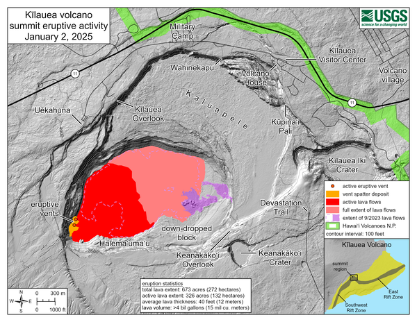
This reference map depicts the Kīlauea summit eruption within Halema‘uma‘u as of January 2, 2025. Since the onset of the eruption on December 23, 2024, it has covered a total of 673 acres (272 hectares) with new lava (pink area), and approximately half that area still hosts active flows (red area). The total lava volume is at least 4 billion gallons (15 million cubic meters), based on measurements from a December 27 overflight and estimates from observations of subsequent activity.
Sources/Usage: Public Domain. View Media Details
Media

This thermal map shows eruptive activity on December 30, 2024, within Halemaʻumaʻu crater at the summit of Kīlauea. Lava fountaining and flows were active in the southwest portion of the caldera. Cooler colors (purple, black) show lower temperatures while hotter colors (orange, yellow) show higher temperatures.
Sources/Usage: Public Domain. View Media Details
Media

This compilation shows thermal maps of Kīlauea summit eruption from December 23-30, 2024. Initially high eruption vigor resulted in lava flows covering much of the southwest portion of the caldera with active lava flows on December 23, 2024. On December 27, 2024, eruptive activity had greatly decreased and active lava was restricted to the vent area in the very southwest part of the caldera. Eruptive vigor increased and on December 30, 2024, lava flows were active in the southwest part of the caldera. Cooler colors (purple, black) show lower temperatures while hotter colors (orange, yellow) show higher temperatures. USGS map by M. Patrick.
Sources/Usage: Public Domain. View Media Details
Media

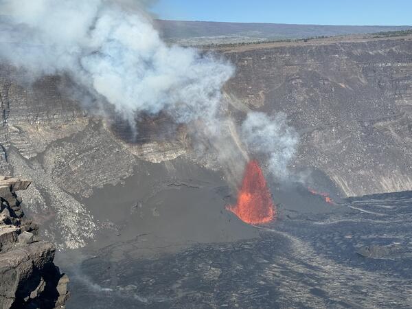
Two vents were active today at Kīlauea summit. The southern vent was producing the dominant fountain (left side of image) and had built a large pyroclastic cone abutting the western caldera wall. The northern vent had a lower fountain (right side of image) and a smaller cone. USGS photo by M. Patrick.
Sources/Usage: Public Domain. View Media Details