
To see how the ground moves in Yellowstone, first look at the rest of North America
Deformation of Earth’s surface can be very subtle. Accurately detecting how the ground moves in the Yellowstone area requires the right frame of reference.
Yellowstone Caldera Chronicles is a weekly column written by scientists and collaborators of the Yellowstone Volcano Observatory. This week's contribution is from Scott K. Johnson, Science Communication Associate at EarthScope Consortium.
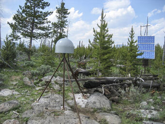
The continuously operating GPS stations in Yellowstone National Park that precisely measure ground movement are part of the much larger Network of the Americas—a continental-scale scientific tool funded by the U.S. National Science Foundation. In addition to monitoring the Yellowstone volcanic system, this network tells us about such processes as tectonic plate motion, earthquake hazards, ground subsidence, and much more! The small ground movements in Yellowstone occur on top of a bigger picture, as all of North America is in constant motion. To fully understand what’s happening in Yellowstone, we have to first account for that bigger picture.
The North American plate is moving towards the Pacific Ocean, while also rotating counter-clockwise. The earthquake hazard on the West Coast—where the North American plate runs into its neighbors—is obvious, from motion the San Andreas Fault and Cascadia Subduction Zone, but to understand earthquakes that might occur due to subtler motion farther inland we have to look for areas where the plate is being slightly squeezed or pulled apart, and this can be hard to see without the proper perspective or reference frame.
Imagine that you are standing near a set of railroad tracks. A train goes whizzing by, and you’re asked to tell whether someone on the train slides a book on a table one inch towards the front of the train or one inch towards the back. Could be tough, right? But if you were standing right there on the train, it would be easy to see which direction the book slid. This is because your point of view differs depending on your location—in other words, your reference frame is important!
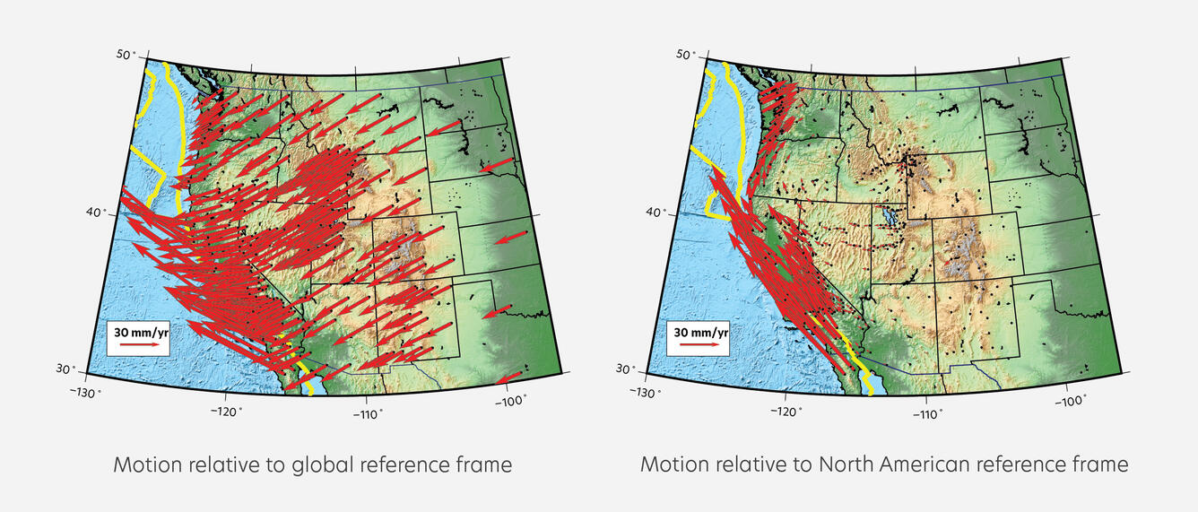
We do something like this to look at subtle movements in Yellowstone despite the whole North American plate being on the move. You can subtract the average motion of the mostly quiet interior of North America—just being on the train negates the train’s speed for your personal frame of reference. This makes the ground movement that differs from the big picture plate motion stand out, and it becomes far easier to identify areas where the Earth’s crust is subtly deforming under stress.
Using this North American reference frame, we can more easily see the ground deformation that is going on in the Yellowstone region. Once the overall motion of the North American plate is removed, it is possible to see that GPS stations northeast of Yellowstone are moving very slightly eastward, while stations to the southwest are moving significantly towards the southwest—so the two sides are gradually pulling away from each other. This is related to the Basin and Range region between Wyoming and the Sierra Nevada mountains of California, where the North American plate is being stretched apart. The magnitude 7.3 Hebgen Lake earthquake in 1959 was a powerful reminder of the fact that this tectonic stretching affects the Yellowstone area, as well.
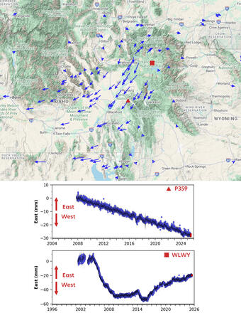
There is even more deformation superimposed on the overall stretching of the ground at Yellowstone. Magma and water beneath the ground can cause Yellowstone Caldera to inflate and deflate like a balloon over time, creating localized deformation patterns. Looking at GPS station positions purely in terms of their east-west movement, those within the Yellowstone Caldera stand out. Rather than continuously migrating in one direction, like those outside the caldera, stations in the caldera move towards or away from the caldera over time due to periods of subtle inflation and deflation.
Not only does all this help us interpret ground motion to understand what is going on in Yellowstone’s volcanic system, but it helps us differentiate between earthquakes related to big-picture tectonics and those related to magma movement and fluid pressure within Yellowstone.
After all, while Yellowstone is an incredibly unique marvel, it’s also connected to the geology that surrounds it. We can’t understand a piece without understanding the whole, complex thought it may be. By making precise measurements inside and outside of the Yellowstone region, we gain the context to isolate the signs of volcanic, hydrothermal, and tectonic activity, detecting even the smallest of changes. It just takes the right frame of reference.