U.S. flag

An official website of the United States government

All Multimedia

Access all multimedia to include images, video, audio, webcams, before-after imagery, and more. Filter and explore with filtering options to refine search. 

Filter Total Items: 24923
Color graphic showing lava lake depth relative to empire state building
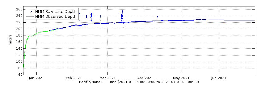
Halema‘uma‘u lava lake depth compared to Empire State Building

Beginning on December 20, 2020, fissure vents opened in the Halema‘uma‘u crater. The former water lake quickly boiled away and, fed by two active fissures, the new lava lake is rising. How high is the lava in the approximately 54 acre lake?

Beginning on December 20, 2020, fissure vents opened in the Halema‘uma‘u crater. The former water lake quickly boiled away and, fed by two active fissures, the new lava lake is rising. How high is the lava in the approximately 54 acre lake?

Color photograph of lava lake
KW webcam image taken on December 24, 2020, around 6:30 a.m. HST

Kīlauea summit KW webam image taken on December 24, 2020, just after 6:30 a.m. HST. The water lake has been replaced by a lava lake; fissures in the wall of Halemaʻumaʻu feed a lava lake that continues to fill the crater.

Kīlauea summit KW webam image taken on December 24, 2020, just after 6:30 a.m. HST. The water lake has been replaced by a lava lake; fissures in the wall of Halemaʻumaʻu feed a lava lake that continues to fill the crater.

Color thermal map of lava lake
December 23, 2020—Kīlauea summit eruption thermal map constructed from

A helicopter overflight yesterday (Dec. 23, 2020) at approximately ~10:30 AM HST allowed for aerial visual and thermal imagery to be collected of the new eruption within Halema'uma'u crater at the summit of Kīlauea Volcano. This preliminary thermal map shows that the new lava lake is 715 m (780 yd) E-W axis and 460 m (500 yd) in N-S axis.

A helicopter overflight yesterday (Dec. 23, 2020) at approximately ~10:30 AM HST allowed for aerial visual and thermal imagery to be collected of the new eruption within Halema'uma'u crater at the summit of Kīlauea Volcano. This preliminary thermal map shows that the new lava lake is 715 m (780 yd) E-W axis and 460 m (500 yd) in N-S axis.

Graph of Halema‘uma‘u lava lake depth, Kīlauea volcano 12/20 - 5/21

Graph showing lava depth (in meters) that has filled Halema‘uma‘u crater, at Kīlauea volcano's summit, after the 2018 collapse, since December 2020. On January 8, 2021, a novel laser rangefinder was stationed at Kīlauea volcano's summit.

Graph showing lava depth (in meters) that has filled Halema‘uma‘u crater, at Kīlauea volcano's summit, after the 2018 collapse, since December 2020. On January 8, 2021, a novel laser rangefinder was stationed at Kīlauea volcano's summit.

Halema'uma'u Lava Lake Fills from Two Spatter and Fountain Sources

23 December 2020 - Kīlauea Volcano US Geological Survey Hawaiian Volcano Observatory. Clip 1: A mid-day helicopter overflight provided aerial views of the eruption in Halema'uma'u crater. This video shows two active fissures erupting lava into a growing lava lake. Visual and thermal images collected during the overflight are used to map the ongoing activity.

23 December 2020 - Kīlauea Volcano US Geological Survey Hawaiian Volcano Observatory. Clip 1: A mid-day helicopter overflight provided aerial views of the eruption in Halema'uma'u crater. This video shows two active fissures erupting lava into a growing lava lake. Visual and thermal images collected during the overflight are used to map the ongoing activity.

Color photo of lava lake
Kīlauea summit eruption - December 23, 2020

Scientists continue to monitor the ongoing eruption in Kīlauea Volcano's summit caldera, Island of Hawai‘i. This photo, from the south rim of Halema‘uma‘u crater and looking north, shows the volcanic gas plume heading west. USGS photo by M. Patrick. 

Scientists continue to monitor the ongoing eruption in Kīlauea Volcano's summit caldera, Island of Hawai‘i. This photo, from the south rim of Halema‘uma‘u crater and looking north, shows the volcanic gas plume heading west. USGS photo by M. Patrick. 

Color photograph of scientists monitoring lava lake
Monitoring Kīlauea's new summit lava lake

A helicopter overflight yesterday (Dec. 22, 2020) at approximately ~11:30 AM HST allowed for aerial visual and thermal imagery to be collected, which was used to map the area of Kīlauea's growing summit lava lake in Halema‘uma‘u crater. As of yesterday afternoon, the lake is over 690 m (yd) E-W axis and 410 m (yd) in N-S axis.

A helicopter overflight yesterday (Dec. 22, 2020) at approximately ~11:30 AM HST allowed for aerial visual and thermal imagery to be collected, which was used to map the area of Kīlauea's growing summit lava lake in Halema‘uma‘u crater. As of yesterday afternoon, the lake is over 690 m (yd) E-W axis and 410 m (yd) in N-S axis.

Color graphic of lava lake rise
Tracking the lava lake in Halema‘uma‘u

Plot showing rise of Kīlauea's summit lava lake since the eruption in Halema‘uma‘u began on December 20 at 9:30 p.m. Since then, laser rangefinder measurements of lava lake surface are made 2–3 times per day. Photos compare the lava lake on the morning of Dec. 21, when it was about 289 ft (87 m) deep, to the evening of Dec. 23 when it was about 511 ft (155 m) deep.

Plot showing rise of Kīlauea's summit lava lake since the eruption in Halema‘uma‘u began on December 20 at 9:30 p.m. Since then, laser rangefinder measurements of lava lake surface are made 2–3 times per day. Photos compare the lava lake on the morning of Dec. 21, when it was about 289 ft (87 m) deep, to the evening of Dec. 23 when it was about 511 ft (155 m) deep.

[KPcam] - Kīlauea Summit from Mauna Loa Strip Road
[KPcam] - Kīlauea Summit from Mauna Loa Strip Road
[KPcam] - Kīlauea Summit from Mauna Loa Strip Road

View from Mauna Loa Strip Road looking at the Kīlauea summit to document volcanic eruption plumes. Webcam installed December 22, 2020.

Map of volcano summit activity
December 21, 2020—Kīlauea summit eruption reference map

The recent eruption at Kīlauea Volcano's summit, within Halema‘uma‘u crater, has generated a lava lake that is being fed by two fissures. Halema‘uma‘u crater has previously been occupied by a water lake (July 2019 to December 2020) and a lava lake (2008 to 2018).

The recent eruption at Kīlauea Volcano's summit, within Halema‘uma‘u crater, has generated a lava lake that is being fed by two fissures. Halema‘uma‘u crater has previously been occupied by a water lake (July 2019 to December 2020) and a lava lake (2008 to 2018).

Color map showing lava lake thickness
December 22, 2020—Kīlauea summit eruption lava lake depth map

Aerial visual imagery collected during an overflight of Kīlauea Volcano's summit just after 11:30 a.m. HST on December 22, 2020, was used to create a preliminary topographic model. When compared to pre-eruption topographic models, it shows that the bottom of Halema'uma'u crater has been filled by almost 150 m (yd) of lava.

Aerial visual imagery collected during an overflight of Kīlauea Volcano's summit just after 11:30 a.m. HST on December 22, 2020, was used to create a preliminary topographic model. When compared to pre-eruption topographic models, it shows that the bottom of Halema'uma'u crater has been filled by almost 150 m (yd) of lava.

Color thermal map of lava lake
December 22, 2020—Kīlauea summit eruption thermal map

A helicopter overflight today (Dec. 22, 2020) at approximately ~11:30 AM HST allowed for aerial visual and thermal imagery to be collected of the new eruption within Halema'uma'u crater at the summit of Kīlauea Volcano. This preliminary thermal map shows that the new lava lake is 690 m (yd) E-W axis and 410 m (yd) in N-S axis.

A helicopter overflight today (Dec. 22, 2020) at approximately ~11:30 AM HST allowed for aerial visual and thermal imagery to be collected of the new eruption within Halema'uma'u crater at the summit of Kīlauea Volcano. This preliminary thermal map shows that the new lava lake is 690 m (yd) E-W axis and 410 m (yd) in N-S axis.

Fissure Activity Within Halema‘uma‘u Crater, Kīlauea Volcano

 Telephoto videos capture fissure activity within Halema‘uma‘u crater on December 22, 2020, at approximately 3:35 PM HST. (1) The first video shows the main northern fissure. The lava fountains have built up a horseshoe-shaped spatter cone (dark in color) around the perimeter of the vent. (2) 2) The second video shows the smaller western fissure.

 Telephoto videos capture fissure activity within Halema‘uma‘u crater on December 22, 2020, at approximately 3:35 PM HST. (1) The first video shows the main northern fissure. The lava fountains have built up a horseshoe-shaped spatter cone (dark in color) around the perimeter of the vent. (2) 2) The second video shows the smaller western fissure.

Fissures, Lava Lake, Wind Vortex at Halema‘uma‘u, Kīlauea

Fissures Feed a Lava Lake at Halema'uma'u, at Kīlauea Volcano's Summit. Since fissures opened on December 20, 2020 in Halema'uma'u crater, USGS–Hawaiian Volcano Observatory scientists have maintained a 24-hour watch from the rim, taking measurements and making visual observations.

Fissures Feed a Lava Lake at Halema'uma'u, at Kīlauea Volcano's Summit. Since fissures opened on December 20, 2020 in Halema'uma'u crater, USGS–Hawaiian Volcano Observatory scientists have maintained a 24-hour watch from the rim, taking measurements and making visual observations.

Color photograph of fissure
Halema‘uma‘u crater fissure

Aerial imagery collected during a USGS Hawaiian Volcano Observatory overflight at approximately 11:35 a.m. HST. This photo shows the western, weaker of the two active fissures in Kīlauea Volcano's ongoing summit eruption in Halema‘uma‘u crater. USGS photo. 

Aerial imagery collected during a USGS Hawaiian Volcano Observatory overflight at approximately 11:35 a.m. HST. This photo shows the western, weaker of the two active fissures in Kīlauea Volcano's ongoing summit eruption in Halema‘uma‘u crater. USGS photo. 

Color photograph of scientist in field
HVO scientist checks monitoring equipment

The current eruption is confined to Halemaʻumaʻu crater within Hawai'i Volcanoes National Park but data from tiltmeters and Global Positioning System (GPS) stations show contraction in the upper portion of the East Rift Zone (an area between Kīlauea’s summit and Pu‘u ‘Ō‘ō).

The current eruption is confined to Halemaʻumaʻu crater within Hawai'i Volcanoes National Park but data from tiltmeters and Global Positioning System (GPS) stations show contraction in the upper portion of the East Rift Zone (an area between Kīlauea’s summit and Pu‘u ‘Ō‘ō).

Color thermal images of lava lake
Kīlauea summit eruption thermal image comparison

This comparison shows thermal images taken yesterday and today during USGS Hawaiian Volcano Observatory helicopter overflights. The main difference in this 24 hour period is the significant rise and infilling of the lava lake within Halema‘uma‘u crater at Kīlauea summit. This morning, the lake depth was measured at approximately 130 yards. USGS images by M.

This comparison shows thermal images taken yesterday and today during USGS Hawaiian Volcano Observatory helicopter overflights. The main difference in this 24 hour period is the significant rise and infilling of the lava lake within Halema‘uma‘u crater at Kīlauea summit. This morning, the lake depth was measured at approximately 130 yards. USGS images by M.

Color photograph of eruption plume
Kīlauea summit Volcano's eruption within Halema‘uma‘u crater

Aerial imagery collected during a USGS Hawaiian Volcano Observatory overflight at approximately 11:35 a.m. HST. The plume from the ongoing eruption rises above the Kīlauea Volcano's summit, within Hawai‘i Volcanoes National Park. Ha‘akulamanu (Sulphur Banks) is visible in the foreground. USGS photo. 

Aerial imagery collected during a USGS Hawaiian Volcano Observatory overflight at approximately 11:35 a.m. HST. The plume from the ongoing eruption rises above the Kīlauea Volcano's summit, within Hawai‘i Volcanoes National Park. Ha‘akulamanu (Sulphur Banks) is visible in the foreground. USGS photo. 

Color photograph of eruption
Kīlauea Volcano's summit eruption within Halema‘uma‘u crater

Aerial imagery collected during a USGS Hawaiian Volcano Observatory overflight at approximately 11:35 a.m. HST. This photo shows the two active fissures in Kīlauea Volcano's ongoing summit eruption in Halema‘uma‘u crater. These fissures in the wall of Halema‘uma‘u crater feed a growing lake at its base.

Aerial imagery collected during a USGS Hawaiian Volcano Observatory overflight at approximately 11:35 a.m. HST. This photo shows the two active fissures in Kīlauea Volcano's ongoing summit eruption in Halema‘uma‘u crater. These fissures in the wall of Halema‘uma‘u crater feed a growing lake at its base.

Overnight Fissure Activity Halema‘uma‘u Crater, Kīlauea

Two fissure vents feed a growing lava lake at the bottom of Halema‘uma‘u crater. A preliminary calculation of volume suggests that since the start of the eruption on December 20, 2020, approximately 8-10 million cubic meters of lava have been erupted. This is equivalent to over 2 billion gallons, the volume of 3,000 Olympic-sized swimming pools.

Two fissure vents feed a growing lava lake at the bottom of Halema‘uma‘u crater. A preliminary calculation of volume suggests that since the start of the eruption on December 20, 2020, approximately 8-10 million cubic meters of lava have been erupted. This is equivalent to over 2 billion gallons, the volume of 3,000 Olympic-sized swimming pools.

Color thermal images of lava lake
USGS webcam--F1cam
USGS webcam--F1cam
USGS webcam--F1cam

A comparison of two thermal images from the F1cam thermal webcam located on the rim of Halema‘uma‘u crater, at the summit of Kīlauea volcano. These two images were taken 48 hours apart. The left image from December 20 at 8:22 a.m.

A comparison of two thermal images from the F1cam thermal webcam located on the rim of Halema‘uma‘u crater, at the summit of Kīlauea volcano. These two images were taken 48 hours apart. The left image from December 20 at 8:22 a.m.

Was this page helpful?