




Albedo—the amount of incoming solar radiation reflected into space from the Earth’s surface—is a key measurement for surface temperatures and plant productivity. It also factors into weather forecasting and climate modeling. Landsat Science Team member Dr.
All Multimedia
Access all multimedia to include images, video, audio, webcams, before-after imagery, and more. Filter and explore with filtering options to refine search.
Filter Total Items: 24985
Eyes on Earth Episode 41 – Albedo
Albedo—the amount of incoming solar radiation reflected into space from the Earth’s surface—is a key measurement for surface temperatures and plant productivity. It also factors into weather forecasting and climate modeling. Landsat Science Team member Dr.

Kīlauea eruption in Halemaʻumaʻu on January 11, 2021
Kīlauea eruption in Halemaʻumaʻu on January 11, 2021The west vent in Halemaʻumaʻu erupting and building a spatter cone complex, with lava cascades feeding a growing lava lake at Kīlauea summit. USGS photograph from January 11, 2021, by B. Carr.
Kīlauea eruption in Halemaʻumaʻu on January 11, 2021
Kīlauea eruption in Halemaʻumaʻu on January 11, 2021The west vent in Halemaʻumaʻu erupting and building a spatter cone complex, with lava cascades feeding a growing lava lake at Kīlauea summit. USGS photograph from January 11, 2021, by B. Carr.

Kīlauea Volcano—Western fissure activity Halema'uma'u (Jan 11, 2021)
Kīlauea Volcano—Western fissure activity Halema'uma'u (Jan 11, 2021)This video taken on January 11, 2021 shows the surface activity had increased at the western fissure over the past two days, within Halema'uma'u at the summit of Kīlauea. Low fountaining was supplying lava to an open channel that poured into the lava lake.
Kīlauea Volcano—Western fissure activity Halema'uma'u (Jan 11, 2021)
Kīlauea Volcano—Western fissure activity Halema'uma'u (Jan 11, 2021)This video taken on January 11, 2021 shows the surface activity had increased at the western fissure over the past two days, within Halema'uma'u at the summit of Kīlauea. Low fountaining was supplying lava to an open channel that poured into the lava lake.

Dusk view of Halema‘uma‘u lava lake, Saturday, January 9, 2021
Dusk view of Halema‘uma‘u lava lake, Saturday, January 9, 2021Around sunset on Saturday (January 9, 2021), a break in the rain allowed HVO scientists to visit and monitor the ongoing eruption in Halema‘uma‘u. The west vent is still actively effusing lava, but outflow into the lava lake is increasingly sluggish, as evidenced by slow-moving crustal plates near the once-vigorous vent outlet.
Dusk view of Halema‘uma‘u lava lake, Saturday, January 9, 2021
Dusk view of Halema‘uma‘u lava lake, Saturday, January 9, 2021Around sunset on Saturday (January 9, 2021), a break in the rain allowed HVO scientists to visit and monitor the ongoing eruption in Halema‘uma‘u. The west vent is still actively effusing lava, but outflow into the lava lake is increasingly sluggish, as evidenced by slow-moving crustal plates near the once-vigorous vent outlet.

Evening view of Halema‘uma‘u lava lake, Saturday, January 9, 2021
Evening view of Halema‘uma‘u lava lake, Saturday, January 9, 2021The arrival of nightfall at Halema‘uma‘u on January 9, 2021, provided a clearer view of ongoing eruptive activity for USGS scientists monitoring the eruption this Saturday evening.
Evening view of Halema‘uma‘u lava lake, Saturday, January 9, 2021
Evening view of Halema‘uma‘u lava lake, Saturday, January 9, 2021The arrival of nightfall at Halema‘uma‘u on January 9, 2021, provided a clearer view of ongoing eruptive activity for USGS scientists monitoring the eruption this Saturday evening.
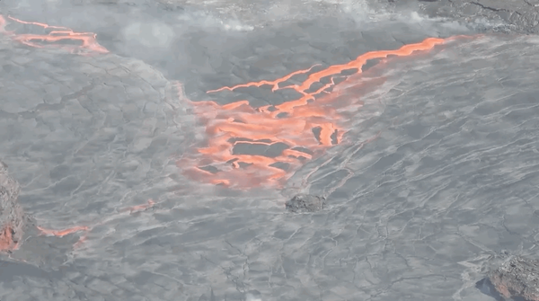
Crustal Overturning (4x speed of original video)
This animated GIF was created from a clip within the original video showing crustal overturning at Kīlauea Volcano in Hawaii. The original video was at 20x the speed of the event, and this animation 4x faster.
This animated GIF was created from a clip within the original video showing crustal overturning at Kīlauea Volcano in Hawaii. The original video was at 20x the speed of the event, and this animation 4x faster.
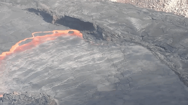
Crustal Overturning (4x speed of original video)
This animated GIF was created from a clip within the original video showing crustal overturning at Kīlauea Volcano in Hawaii. The original video was at 20x the speed of the event, and this animation 4x faster.
This animated GIF was created from a clip within the original video showing crustal overturning at Kīlauea Volcano in Hawaii. The original video was at 20x the speed of the event, and this animation 4x faster.

Crustal Overturning in Halema‘uma‘u Lava Lake
This video shows crustal foundering and resurfacing at the lava lake in Halema‘uma‘u, at the summit of Kīlauea on January 8, 2021. Recently this foundering process has been common in the eastern portion of the lake. The video is shown at 20x speed.
This video shows crustal foundering and resurfacing at the lava lake in Halema‘uma‘u, at the summit of Kīlauea on January 8, 2021. Recently this foundering process has been common in the eastern portion of the lake. The video is shown at 20x speed.

Halema‘uma‘u West Fissure Activity (Jan 8, 2021)
This video shows activity at the western fissure, in Halema‘uma‘u at the summit of Kīlauea on January 8, 2021. The lava stream entering the lake appeared weaker than several days ago, when a dome fountain was active.
This video shows activity at the western fissure, in Halema‘uma‘u at the summit of Kīlauea on January 8, 2021. The lava stream entering the lake appeared weaker than several days ago, when a dome fountain was active.

Halema‘uma‘u just after sunset on January 8, 2021
Kīlauea’s summit lava lake, in Halema‘uma‘u, just after sunset on January 8, 2021. This view is to the north, from the south rim of the crater. HVO scientists continue to monitor the eruption within an area of Hawai‘i Volcanoes National Park that remains closed to the public for safety reasons. USGS image by N. Deligne.
Kīlauea’s summit lava lake, in Halema‘uma‘u, just after sunset on January 8, 2021. This view is to the north, from the south rim of the crater. HVO scientists continue to monitor the eruption within an area of Hawai‘i Volcanoes National Park that remains closed to the public for safety reasons. USGS image by N. Deligne.

Irrigated Land Use, Adelaida Area, San Luis Obispo County, CA
Irrigated Land Use, Adelaida Area, San Luis Obispo County, CAIrrigated land-use in the Adelaida Area of San Luis Obisbo County, CA for 1984, 1996, 2004, 2014, and 2016. Numbers indicate acres and percent of total acres.
Irrigated Land Use, Adelaida Area, San Luis Obispo County, CA
Irrigated Land Use, Adelaida Area, San Luis Obispo County, CAIrrigated land-use in the Adelaida Area of San Luis Obisbo County, CA for 1984, 1996, 2004, 2014, and 2016. Numbers indicate acres and percent of total acres.

3D Model of Halema'uma'u Crater (Jan 7, 2021)
Visual photographs taken during a helicopter overflight of Halema'uma'u crater on January 7, 2021 (at Kīlauea Volcano) are used to create a 3D model of the crater. This technique is called structure-from-motion photogrammetry and uses the multiple perspectives captured in dozens of photos to reconstruct the crater shape on a computer.
Visual photographs taken during a helicopter overflight of Halema'uma'u crater on January 7, 2021 (at Kīlauea Volcano) are used to create a 3D model of the crater. This technique is called structure-from-motion photogrammetry and uses the multiple perspectives captured in dozens of photos to reconstruct the crater shape on a computer.
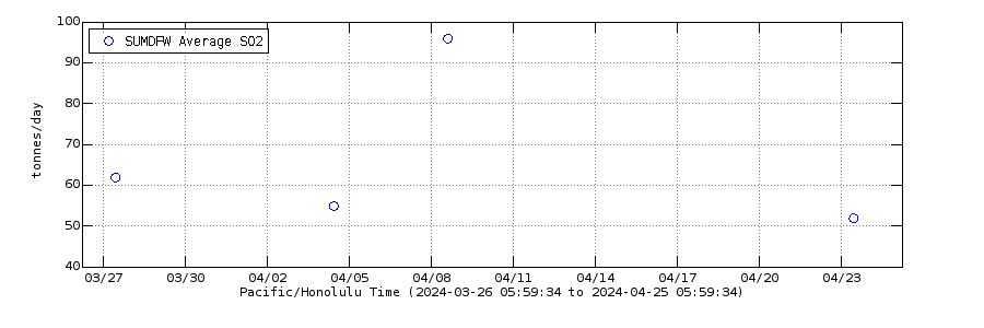
Average measurements of SO2 from Kilauea summit in the past month
Average measurements of SO2 from Kilauea summit in the past monthSulfur dioxide (SO2) emission rates measured using an upward-looking ultraviolet spectrometer. These data are collected by traversing the gas plume in a vehicle or helicopter, downwind of Halema‘uma‘u, generally within and/or southwest of Kīlauea caldera.
Average measurements of SO2 from Kilauea summit in the past month
Average measurements of SO2 from Kilauea summit in the past monthSulfur dioxide (SO2) emission rates measured using an upward-looking ultraviolet spectrometer. These data are collected by traversing the gas plume in a vehicle or helicopter, downwind of Halema‘uma‘u, generally within and/or southwest of Kīlauea caldera.

Halema‘uma‘u Lava Lake Aerial Views (Jan 7, 2021)
A helicopter overflight at approximately 10:30 a.m. HST provided views of the ongoing eruption within Halema‘uma‘u crater. Video is shown at 3 x speed. HVO geologists noted that the dome fountain, which had been persistent near the base of the west vent area, had subsided and was no longer present. Lava continues to enter the lake at the base of the west vents.
A helicopter overflight at approximately 10:30 a.m. HST provided views of the ongoing eruption within Halema‘uma‘u crater. Video is shown at 3 x speed. HVO geologists noted that the dome fountain, which had been persistent near the base of the west vent area, had subsided and was no longer present. Lava continues to enter the lake at the base of the west vents.

Islands in Halemaumau and Kilauea Volcano lava lake, 1917 & 2021
Islands in Halemaumau and Kilauea Volcano lava lake, 1917 & 2021Islands have been observed in Kīlauea lava lakes for more than 100 years—some move and some are moored. These two photographs of Halemaʻumaʻu crater from 1917 (top) and 2021 (bottom) show islands floating in lava lakes.
Islands in Halemaumau and Kilauea Volcano lava lake, 1917 & 2021
Islands in Halemaumau and Kilauea Volcano lava lake, 1917 & 2021Islands have been observed in Kīlauea lava lakes for more than 100 years—some move and some are moored. These two photographs of Halemaʻumaʻu crater from 1917 (top) and 2021 (bottom) show islands floating in lava lakes.

Kīlauea summit aerial imagery - January 7, 2021
This photo, taken during an overflight of Kīlauea's summit this morning (January 7, 2021), shows the southeast margin of Halemaʻumaʻu's growing lava lake. The photo shows the boundary between the active portion of the lava lake (left) and the subtle levee around the lake perimeter that allows the lake to be slightly perched.
This photo, taken during an overflight of Kīlauea's summit this morning (January 7, 2021), shows the southeast margin of Halemaʻumaʻu's growing lava lake. The photo shows the boundary between the active portion of the lava lake (left) and the subtle levee around the lake perimeter that allows the lake to be slightly perched.

Kīlauea summit aerial imagery - January 7, 2021
During an overflight of Kīlauea summit today (January 7, 2021) at approximately 10:30 a.m. HST, HVO geologists captured this image of the growing lava lake within Halemaʻumaʻu. Sunny weather allowed for clear views of Mauna Loa, to the west. USGS photo by M. Patrick.
During an overflight of Kīlauea summit today (January 7, 2021) at approximately 10:30 a.m. HST, HVO geologists captured this image of the growing lava lake within Halemaʻumaʻu. Sunny weather allowed for clear views of Mauna Loa, to the west. USGS photo by M. Patrick.

Kīlauea summit aerial imagery - January 7, 2021
Aerial image of the active west vent area and the largest island in Halemaʻumaʻu's growing lava lake. During the overflight of Kīlauea's summit today (January 7, 2021) at approximately 10:30 a.m. HST, HVO geologists noted that the dome fountain, which had been persistent near the base of the west vent area, had subsided and was no longer present. USGS photo by K.
Aerial image of the active west vent area and the largest island in Halemaʻumaʻu's growing lava lake. During the overflight of Kīlauea's summit today (January 7, 2021) at approximately 10:30 a.m. HST, HVO geologists noted that the dome fountain, which had been persistent near the base of the west vent area, had subsided and was no longer present. USGS photo by K.

Thermal image of the lava lake at the summit of Kīlauea - Jan. 7, 2021
Thermal image of the lava lake at the summit of Kīlauea - Jan. 7, 2021This thermal image, looking northwest, shows the distribution of activity on the lava lake at Kīlauea's summit. The lake is slightly perched and surrounded along its perimeter by a lower ledge of cooler lava. The western fissure, in the wall of Halema‘uma‘u crater, is visible in the upper left portion of the image, just above the lake.
Thermal image of the lava lake at the summit of Kīlauea - Jan. 7, 2021
Thermal image of the lava lake at the summit of Kīlauea - Jan. 7, 2021This thermal image, looking northwest, shows the distribution of activity on the lava lake at Kīlauea's summit. The lake is slightly perched and surrounded along its perimeter by a lower ledge of cooler lava. The western fissure, in the wall of Halema‘uma‘u crater, is visible in the upper left portion of the image, just above the lake.

Double rainbow extending over the lava lake in Halemaʻumaʻu crater
Double rainbow extending over the lava lake in Halemaʻumaʻu craterView to the northwest from the south rim of Halemaʻumaʻu crater showing the lava lake in Halemaʻumaʻu at Kīlauea Volcano's summit. The active western fissure is visible above the lake, producing minor spatter and a gas plume from vents at the top.
Double rainbow extending over the lava lake in Halemaʻumaʻu crater
Double rainbow extending over the lava lake in Halemaʻumaʻu craterView to the northwest from the south rim of Halemaʻumaʻu crater showing the lava lake in Halemaʻumaʻu at Kīlauea Volcano's summit. The active western fissure is visible above the lake, producing minor spatter and a gas plume from vents at the top.

HVO geologist measures lava lake features with a laser rangefinder
HVO geologist measures lava lake features with a laser rangefinderAn HVO geologist takes Kīlauea summit eruption lake-level, spatter-cone, and dome-fountain measurements with a laser rangefinder. The top of the dome fountain in Halemaʻumaʻu was up to 5 meters (16 ft) above the lake surface. The lake elevation suggests a maximum lava lake depth of approximately 193 m (211 yd).
HVO geologist measures lava lake features with a laser rangefinder
HVO geologist measures lava lake features with a laser rangefinderAn HVO geologist takes Kīlauea summit eruption lake-level, spatter-cone, and dome-fountain measurements with a laser rangefinder. The top of the dome fountain in Halemaʻumaʻu was up to 5 meters (16 ft) above the lake surface. The lake elevation suggests a maximum lava lake depth of approximately 193 m (211 yd).