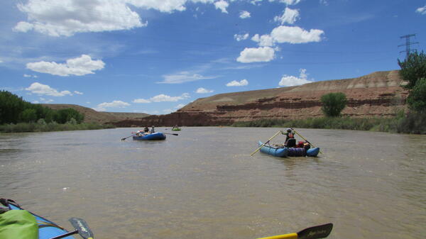
U.S. flag

An official website of the United States government

Images

Explore our planet through photography and imagery, including climate change and water all the way back to the 1800s when the USGS was surveying the country by horse and buggy.

Filter Total Items: 21608
caribou crossing a road within the Kuparuk oil field, Alaska
Caribou crossing a road, within Kuparuk oil field, North Slope, Alaska

Central Arctic Herd - caribou crossing a road within the Kuparuk oil field on the North Slope of Alaska. The photo was taken during the summer mosquito harassment period. 

Central Arctic Herd - caribou crossing a road within the Kuparuk oil field on the North Slope of Alaska. The photo was taken during the summer mosquito harassment period. 

Central Arctic Herd caribou next to pipeline, North Slope of Alaska
Central Arctic Herd caribou within the Kuparuk oil field, Alaska

Central Arctic Herd caribou within the Kuparuk oil field on the North Slope of Alaska. The photo was taken during the summer mosquito harassment period. 

Central Arctic Herd caribou within the Kuparuk oil field on the North Slope of Alaska. The photo was taken during the summer mosquito harassment period. 

crumbling house on grassy field
Palu Earthquake Damage to House from Liquefaction

House destroyed by Palu earthquake-induced liquefaction. Note standing water which indicates a nearly surface-level water table that contributed to the widespread liquefaction.

House destroyed by Palu earthquake-induced liquefaction. Note standing water which indicates a nearly surface-level water table that contributed to the widespread liquefaction.

This image shows a forest of coniferous trees.
North Rim Grand Canyon conifer forest

Conifers, incluing ponderosa pines, can be seen along the north rim of the Grand Canyon.

Conifers, incluing ponderosa pines, can be seen along the north rim of the Grand Canyon.

Water in a glass cylinder, showing the meniscus.
A meniscus is seen along the edges of this glass cylinder.

What is a meniscus?

A meniscus is a curve in the surface of a molecular substance (water, of course) when it touches another material. With water, you can think of it as when water sticks to the inside of a glass.

Why a meniscus occurs

What is a meniscus?

A meniscus is a curve in the surface of a molecular substance (water, of course) when it touches another material. With water, you can think of it as when water sticks to the inside of a glass.

Why a meniscus occurs

Caribou with Calves during Summer in Northern Alaska

Caribou with calves from the Central Arctic Herd in the Kuparuk Oil Field, Alaska.

Caribou with calves from the Central Arctic Herd in the Kuparuk Oil Field, Alaska.

A paper clip floating on water, due to surface tension.
Paper clip can float on water, due to high surface tension of water

It seems to defy the laws of physics, but a paper clip made of steel can indeed float on the water surface. The high surface tension helps the paper clip - with much higher density - float on the water.

It seems to defy the laws of physics, but a paper clip made of steel can indeed float on the water surface. The high surface tension helps the paper clip - with much higher density - float on the water.

Photo of scientist standing in water operating equipment next to a boat
USGS intern Kira Waldman collecting water-quality samples

Each summer, interns join USGS offices around the Nation in support of our water studies.

Each summer, interns join USGS offices around the Nation in support of our water studies.

image related to volcanoes. See description
Different portions of the ponds have different colors, presumably reflecting dif

Different portions of the ponds have different colors, presumably reflecting different amounts or varying chemistry of dissolved particles in the water.

Different portions of the ponds have different colors, presumably reflecting different amounts or varying chemistry of dissolved particles in the water.

Three SCREE hikers traversing a thin hiking trail
Hiking up to the Bowknot Bend

Three SCREE hikers traversing a thin hiking trail to the saddle that separates the two arms of the Green River that defines the Bowknot Bend at Mile 63.

Three SCREE hikers traversing a thin hiking trail to the saddle that separates the two arms of the Green River that defines the Bowknot Bend at Mile 63.

magnification of a zircon crystal that was analyzed for age dating of Yellowstone lava
magnified zircon crystal showing crystal growth age dating Yellowstone

Sections of a zircon crystal, only 100 micrometers across, showing stages of the crystal's growth. Upper panel shows the outer surface of the crystal, which is 131,000 years old based on 238U-230Th dating. This is when the crystal stopped growing. Lower panel shows the interior of the same zircon crystal.

Sections of a zircon crystal, only 100 micrometers across, showing stages of the crystal's growth. Upper panel shows the outer surface of the crystal, which is 131,000 years old based on 238U-230Th dating. This is when the crystal stopped growing. Lower panel shows the interior of the same zircon crystal.

Schematic diagram of Yellowstone's current magmatic system.

Schematic diagram of Yellowstone's current magmatic system. A silicic crystal-mush (gray region with white crystals) is thought to underlie the caldera at a depth of ~5 km to 15 km, with more mafic basalt (in black) underneath.

Schematic diagram of Yellowstone's current magmatic system. A silicic crystal-mush (gray region with white crystals) is thought to underlie the caldera at a depth of ~5 km to 15 km, with more mafic basalt (in black) underneath.

Taken from the saddle, a panoramic view of the Bowknot Bend
The Bowknot Bend
The Bowknot Bend
The Bowknot Bend

Taken from the saddle, a panoramic view of the Bowknot Bend of the Green River. The Bowknot Bend is 7 river miles around. Erosion will eventually shorten the river course considerably.

Taken from the saddle, a panoramic view of the Bowknot Bend of the Green River. The Bowknot Bend is 7 river miles around. Erosion will eventually shorten the river course considerably.

red and white round buoys strung across the blue water of the California Aqueduct
California Aqueduct, San Joaquin Valley

The California Aqueduct flowing near Huron, CA in the San Joaquin Valley.  This spot is near one of several USGS land subsidence monitoring stations in the San Joaquin Valley.

The California Aqueduct flowing near Huron, CA in the San Joaquin Valley.  This spot is near one of several USGS land subsidence monitoring stations in the San Joaquin Valley.

Color photograph of Carolyn Donlin accepting Volcano Watch award
Carolyn Donlin accepting Volcano Watch award

On behalf of the Hawaiian Volcano Observatory, Carolyn Donlin, Chief of the USGS Menlo Park Publishing Service Center, accepted an award from the National Association of Government Communicators recognizing HVO's weekly "Volcano Watch" articles as excellent communication products.

On behalf of the Hawaiian Volcano Observatory, Carolyn Donlin, Chief of the USGS Menlo Park Publishing Service Center, accepted an award from the National Association of Government Communicators recognizing HVO's weekly "Volcano Watch" articles as excellent communication products.

Four recently hatched piping plover chicks huddle in the nest bowl

Four recently hatched piping plover chicks huddle in the nest bowl on the Garrison Reach of the Missouri River, North Dakota

Four recently hatched piping plover chicks huddle in the nest bowl on the Garrison Reach of the Missouri River, North Dakota

at river's edge, a laptop displays graphs (foreground) while a hydrologist wades in the water with equipment (background)
Measuring Stream Discharge with Acoustic Doppler Current Profiler

The USGS maintains and monitors hundreds of streamgages across California, as well as across the Nation. Nearly all data collected by the USGS is made public and most in near real-time. Cities can use the data for flood mitigation and water supply.

The USGS maintains and monitors hundreds of streamgages across California, as well as across the Nation. Nearly all data collected by the USGS is made public and most in near real-time. Cities can use the data for flood mitigation and water supply.

Sampling Big Sandy River below Farson, WY

Sampling Big Sandy River below Farson, WY

Collecting water samples for eDNA analysis of foothill yellow-legged frog
Collecting water samples for eDNA analysis to estimate foothill yellow

USGS technicians collect water samples for eDNA analysis to estimate foothill yellow-legged frog (Rana boylii) presence at historically occupied sites throughout Oregon. These data are important for assessing the species' status and conservation needs. 

USGS technicians collect water samples for eDNA analysis to estimate foothill yellow-legged frog (Rana boylii) presence at historically occupied sites throughout Oregon. These data are important for assessing the species' status and conservation needs. 

This image shows brown layered sedimentary rocks and the brown-colored Colorado River.
Dead Horse Point State Park, Utah

This image from a viewpoint at Dead Horse State Park in Utah shows horizontal Mesozoic sedimentary rocks characteristic of the Colorado Plateau. The Colorado River can be seen from this vantage point and this state park is located between Canyonlands National Park to the southwest and Arches National Park to the northeast.

This image from a viewpoint at Dead Horse State Park in Utah shows horizontal Mesozoic sedimentary rocks characteristic of the Colorado Plateau. The Colorado River can be seen from this vantage point and this state park is located between Canyonlands National Park to the southwest and Arches National Park to the northeast.