U.S. flag

An official website of the United States government

Images

Explore our planet through photography and imagery, including climate change and water all the way back to the 1800s when the USGS was surveying the country by horse and buggy.

Filter Total Items: 21366
Color photograph of lava lake
KW webcam image taken January 6, 2021, just after 6:30 a.m. HST.

Kīlauea summit KW webam image taken on January 6, 2021, just after 6:30 a.m. HST. The eruption in Halemaʻumaʻu continues and this photo shows that activity remains focused at the west vent as of Jan. 6 morning.

Kīlauea summit KW webam image taken on January 6, 2021, just after 6:30 a.m. HST. The eruption in Halemaʻumaʻu continues and this photo shows that activity remains focused at the west vent as of Jan. 6 morning.

GIF showing bubbling lava in a lake
Lava Bubbling Inside of a Lava Lake

An animated GIF showing bubbling lava from inside the lava lake at Kīlauea Volcano, Hawaii on Jan 6, 2021.

An animated GIF showing bubbling lava from inside the lava lake at Kīlauea Volcano, Hawaii on Jan 6, 2021.

Color photograph of lava lake
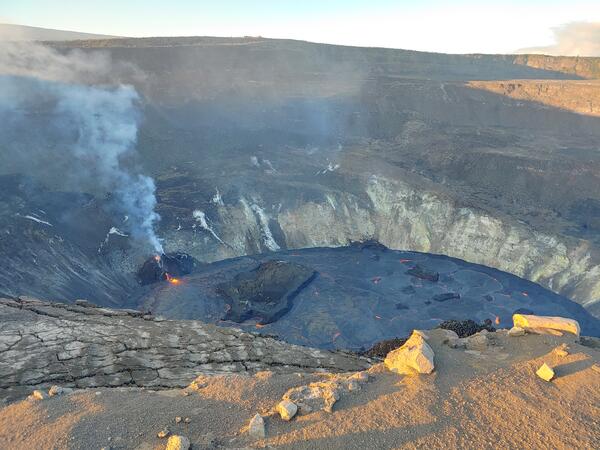
Rainbow over the western fissure erupting in Halemaʻumaʻu crater

View to the north-northwest from the south rim of Halemaʻumaʻu crater and showing the activity at the western fissure, partly obscured by a rainbow.

Color photograph of lava lake
Halema‘uma‘u lava lake on the evening of 5 January, 2021

View looking north across Kīlauea caldera from the south rim of Halema‘uma‘u, showing the ongoing eruption around 5:30 p.m. HST on January 5, 2021. The west vent activity included the “dome fountain,” effusive lava flows from a mid-elevation vent, and weak strombolian spattering activity from the high-elevation vent. USGS photo by K. Lynn. 

View looking north across Kīlauea caldera from the south rim of Halema‘uma‘u, showing the ongoing eruption around 5:30 p.m. HST on January 5, 2021. The west vent activity included the “dome fountain,” effusive lava flows from a mid-elevation vent, and weak strombolian spattering activity from the high-elevation vent. USGS photo by K. Lynn. 

Color photograph of volcanic vent
Halema‘uma‘u west vent activity for the evening of 5 January, 2021

Telephoto view of the lava flow and “dome fountain” activity at the west vent of the ongoing eruption in Halema‘uma‘u, Kīlauea Volcano summit, at 5:45 p.m. HST on 5 January, 2021. USGS photo by K. Lynn. 

Color map of topography
January 5, 2021—Kīlauea summit topographic changes

Topography of Halema'uma'u crater, at the summit of Kīlauea Volcano, on December 26, 2020 (left), and January 5, 2021 (right). These Digital Elevation Models (DEMs) are created from aerial imagery collected during helicopter overflights. They show that the lava lake within Halema'uma'u continues to rise and deepen.

Topography of Halema'uma'u crater, at the summit of Kīlauea Volcano, on December 26, 2020 (left), and January 5, 2021 (right). These Digital Elevation Models (DEMs) are created from aerial imagery collected during helicopter overflights. They show that the lava lake within Halema'uma'u continues to rise and deepen.

Color photograph of volcanic vent
Kīlauea west vent “dome fountain” activity for 5 January, 2021

View through the laser rangefinder from the south rim of Halema‘uma‘u, Kīlauea Volcano summit, and showing the “dome fountain” and west vent effusive lava flow around 3:30 p.m. HST on January 5, 2021. A glowing vent is also visible at the top of the spatter structure. USGS photo by K. Lynn.

View through the laser rangefinder from the south rim of Halema‘uma‘u, Kīlauea Volcano summit, and showing the “dome fountain” and west vent effusive lava flow around 3:30 p.m. HST on January 5, 2021. A glowing vent is also visible at the top of the spatter structure. USGS photo by K. Lynn.

United States map showing outlines of state boundaries. Symbols indicate locations of over 2,500 network wells where current con
January 4, 2021, Below Normal Groundwater Levels Network

Map indicates groundwater sites within the USGS Active Groundwater Level network where the most recent groundwater-level measurement is in the 24th percentile or lower in the month of measurement over the period of record for the well.

Map indicates groundwater sites within the USGS Active Groundwater Level network where the most recent groundwater-level measurement is in the 24th percentile or lower in the month of measurement over the period of record for the well.

Color photographs of lava lake
Channel crusting over at the base Halema'uma'u's west vent

The west vent in Halema‘uma‘u crater continues to erupt at Kīlauea’s summit. These telephoto images from December 29 (left) and December 30 (right) compare the lava lake surface below the west vent. The west vent is supplying lava to the lake through a crusted over channel, which was starting to form by December 30. USGS photos by H. Dietterich.

The west vent in Halema‘uma‘u crater continues to erupt at Kīlauea’s summit. These telephoto images from December 29 (left) and December 30 (right) compare the lava lake surface below the west vent. The west vent is supplying lava to the lake through a crusted over channel, which was starting to form by December 30. USGS photos by H. Dietterich.

Color photograph of volcanic vent spattering
Kīlauea summit eruption - Jan. 3, 2020, at 1:30 a.m. HST

Early this morning, the west vents in Halema‘uma‘u spattered from two places at the top of a small cone plastered on the northwest wall. This process can be seen in Kīlauea Volcano's summit F1 thermal webcam view of the lava lake.

Early this morning, the west vents in Halema‘uma‘u spattered from two places at the top of a small cone plastered on the northwest wall. This process can be seen in Kīlauea Volcano's summit F1 thermal webcam view of the lava lake.

Color photograph of volcanic vent spattering and lava lake
Kīlauea summit eruption - Jan. 3, 2020, at 1:30 a.m. HST

At Halema‘uma‘u, the west vents (visible in the foreground of this photo as two glowing holes on a cone-shaped feature) erupt occaisional spatter.

Eruptions of Steamboat Geyser over time

Eruptions of Steamboat Geyser over time.  (A) Cumulative eruptions of Steamboat Geyser since 1960. Each dot represents an eruption. (B) Comparative plot of the cumulative eruptions in each active phase (1960s, 1980s, and 2018-). Data from GeyserTimes.

Eruptions of Steamboat Geyser over time.  (A) Cumulative eruptions of Steamboat Geyser since 1960. Each dot represents an eruption. (B) Comparative plot of the cumulative eruptions in each active phase (1960s, 1980s, and 2018-). Data from GeyserTimes.

Color photograph of lava lake and volcanic vent
Kīlauea summit eruption - Jan. 2, 2021, at 7 a.m. HST

View of the west vent area and lava lake in Halema‘uma‘u, at Kīlauea Volcano's summit. USGS photo by K. Lynn.

Color photograph of lava lake and volcanic vent
Kīlauea summit eruption - Jan. 2, 2021, at 7:30 a.m. HST

Telephoto photograph of the west vent area and lava lake in Halema‘uma‘u, at Kīlauea Volcano's summit. USGS photo by K. Lynn.

Steamboat Geyser eruption signals

Steamboat Geyser eruption signals recorded by nearby monitoring instruments. The vertical pink lines mark when the signal first appears. (A) Seismic station YNM records a signal which slowly tapers as the eruption decreases in intensity. Spikes seen before the eruption are mostly due to human activity.

Steamboat Geyser eruption signals recorded by nearby monitoring instruments. The vertical pink lines mark when the signal first appears. (A) Seismic station YNM records a signal which slowly tapers as the eruption decreases in intensity. Spikes seen before the eruption are mostly due to human activity.

Color photograph of lava lake
Halema‘uma‘u lava lake beginning to perch

Over the past week, the lava lake in Halema‘uma‘u has developed a subtle levee around its perimeter that allows the lake to be slightly perched above its base, like a mesa. The levees grow from repeated small overflows, and the rafting and piling of pieces of surface crust that fuse together into a barrier that impounds the fluid lake.

Over the past week, the lava lake in Halema‘uma‘u has developed a subtle levee around its perimeter that allows the lake to be slightly perched above its base, like a mesa. The levees grow from repeated small overflows, and the rafting and piling of pieces of surface crust that fuse together into a barrier that impounds the fluid lake.

Color photograph of lava lake crust
Kīlauea eruption in Halema‘uma‘u on Jan. 1, 2021

Kīlauea's summit lava lake in Halemaʻumaʻu continues to re-surface. This process is called crustal foundering, in which pieces of solidified lava crust on the surface of the lava lake break and sink back into the liquid portion. USGS photo by M. Patrick. 

Kīlauea's summit lava lake in Halemaʻumaʻu continues to re-surface. This process is called crustal foundering, in which pieces of solidified lava crust on the surface of the lava lake break and sink back into the liquid portion. USGS photo by M. Patrick. 

Color photograph of lava lake
Kīlauea eruption in Halema‘uma‘u on Jan. 1, 2021

The western portion of the lava lake in Halema‘uma‘u, Kīlauea Volcano summit. The island has migrated closer to the west vent area, which remains active. USGS photo by M. Patrick. 

The western portion of the lava lake in Halema‘uma‘u, Kīlauea Volcano summit. The island has migrated closer to the west vent area, which remains active. USGS photo by M. Patrick. 

Color photograph of lava lake crust
Kīlauea eruption in Halema‘uma‘u on Jan. 1, 2021

Kīlauea's summit lava lake in Halemaʻumaʻu is continually re-surfacing. Like the 2008-2018 lava lake, the current lava lake is exhibiting crustal foundering, when fragments of solidified lava crust on the surface break and sink back into the liquid portion.  USGS photo by M. Patrick. 

Kīlauea's summit lava lake in Halemaʻumaʻu is continually re-surfacing. Like the 2008-2018 lava lake, the current lava lake is exhibiting crustal foundering, when fragments of solidified lava crust on the surface break and sink back into the liquid portion.  USGS photo by M. Patrick. 

Color photograph of lava lake surface
Kīlauea eruption in Halema‘uma‘u on Jan. 1, 2021

Kīlauea eruption in Halema‘uma‘u on Jan. 1, 2021. The channel-like feature remains visible on the lava lake surface within Halemaʻumaʻu crater at Kīlauea Volcano's summit. This feature originates from the influx of lava from the western fissure. USGS photo by M. Patrick. 

Kīlauea eruption in Halema‘uma‘u on Jan. 1, 2021. The channel-like feature remains visible on the lava lake surface within Halemaʻumaʻu crater at Kīlauea Volcano's summit. This feature originates from the influx of lava from the western fissure. USGS photo by M. Patrick. 

Was this page helpful?