
Deep Dive: Managing for the Future of the Colorado River Basin
The Colorado River delivers drinking water to more than 40 million people and hydroelectric power to millions in the West. Explore how the CASCs are helping partners implement proactive water planning and management, understand the impacts of different reservoir operations on aquatic life, adapt to natural hazards, and more.

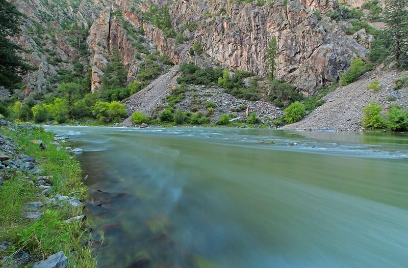
The Colorado River is often called the ‘lifeline of the Southwest’—and for good reason. Fed by snowmelt originating in the Rocky Mountains, the river winds 1450 miles through semiarid plateaus, deep canyons, and reservoirs, delivering drinking water to more than 40 million people and hydroelectric power to millions. As it carves past piñon-juniper woodland and vast creosote-dotted deserts, the river sustains seven states and 30 Tribal Nations, fueling a trillion-dollar economy that include billions in recreational spending and hundreds of thousands of jobs.
The river is equally vital to the nation's food supply, irrigating approximately five million acres of farmland, providing water for nearly 90% of the nation’s winter vegetables, and generating more than one billion dollars annually from agricultural water use. Its drainage basin, which includes an expansive web of tributaries, provides habitats for thousands of plant and wildlife species across 250,000 square miles of diverse ecosystems. However, this river system, and the ecosystems, communities, and economies that depend on it, is growing increasingly vulnerable under the pressures of a changing climate.
Over the last few decades, changes in precipitation patterns, rising temperatures, and a decades-long drought have significantly altered snowpack levels and the timing and duration of melting at the river’s source. When reduced quantities of snowfall melt too quickly and above-average temperatures increase evaporative demand, streams run dry early in the season, leaving behind parched soils and thirsty forests and rangelands that soak up water before it can even reach the river. Streamflow decreases and reservoir stores diminish, all while human irrigation demand remains high. Over time, less water becomes readily available for the rural and urban communities and riparian ecosystems that rely on the river’s consistent flow.
CASC Science
For over a decade, the USGS Climate Adaptation Science Centers (CASCs) have engaged with resource managers along the Colorado River system to address these growing threats. CASC-supported researchers model historic and future temperature and precipitation conditions, forecast changes in native and invasive fish populations, and co-develop riparian adaptation strategies with federal, Tribal, state, and local partners.
To date, approximately \$4.7 million has been invested in 18 Colorado River-focused projects across three CASCs (Southwest, North Central and National). As they study the river’s future streamflow, wade through schools of humpback chub, and monitor vegetation health, CASC-funded scientists provide critical science for decision-making and support adaptation strategies across the river basin, from snowflake to sea.
The following sections outline some of this critical work:
Forecasting Flow
Aquatic Life
Managing Hazard Risk
Developing Tools of the Trade
Forecasting Flow on the Colorado
High-altitude Rocky Mountain snowpack and precipitation are the fundamental sources of water for the Colorado River. Each year, the mountains act as natural wintertime reservoirs, accumulating snow that melts and feeds into the river come springtime. However, rising temperatures have altered the amount and timing of annual snowmelt and streamflow, exacerbating drought conditions and placing pressure on land and water resource managers.
To support proactive water planning and management, CASC scientists are working to understand and anticipate how changes in temperature and precipitation may influence water levels across the basin.
Our Science
Understanding the influence of spring and summer rains
While most research focuses on winter snowpack and runoff, CASC researchers are filling a critical gap in knowledge by examining how spring and summer rains, including from the North American monsoon, shape water availability and landscape conditions in the Colorado River Basin. Understanding how non-winter precipitation is changing can help inform year-round management of water and other natural resources in the region.
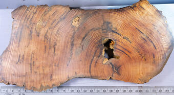
Tree-rings give insight into living with drought
CASC researchers have analyzed historic drought using 500+ years of tree-ring data to better understand how warmer temperatures may influence drought conditions today and in the future. The researchers found that both historic and recent drought scenarios show greater reductions in runoff as temperatures warm. These results provide river managers with a scientific and historic foundation for anticipating future drought conditions to better plan for water shortages and manage risk in the face of climate uncertainty.
And More
Researchers have also tested climate modeling techniques to project future streamflow, examined the impacts of atmospheric river events on water resources, studied how downslope winds and precipitation affect fire risk and provided partners with projections of climate extremes and their subsequent impacts on water availability in the region.

Aquatic Life in a Regulated River
As the Colorado River winds through the Southwest, its natural flow is slowed, diverted, and channeled through a series of reservoirs and infrastructure projects. At the Utah-Arizona border, the river drains into Lake Powell, a massive man-made lake where the water is stored and then heavily regulated across the Glen Canyon Dam and into the Grand Canyon. Near Las Vegas, the river turns south along the Arizona-Nevada border to form Lake Mead, the largest reservoir in the United States by water capacity.
In recent years, the historically low water levels of the reservoirs, rising temperatures, and subsequent warm-water dam releases have disrupted downstream aquatic ecosystems, putting native fish species and riparian habitats at risk. As new long-term water agreements are being negotiated for the Colorado River, CASC researchers are providing timely, science-based strategies that outline the trade-offs and benefits of different reservoir operations and their impacts on the river’s aquatic life.
Our Science
Balancing water supply with ecosystem health
USGS researchers are investigating how future allocation and reservoir storage decisions could affect native fish populations, including rare and federally listed species such as the humpback chub. Researchers found that projected changes in reservoir levels, and warmer river temperatures associated with low reservoir levels, could lead to an increased movement of invasive, predatory smallmouth bass across dam turbines and into the Grand Canyon. The team’s real-world implementation of predictive models has helped identify optimal management strategies that support both human water needs and ecological goals. Learn more>>
Supporting freshwater species recovery efforts
Since 2009, CASC research has explored how climate and land use shifts could impact aquatic habitats and fish communities in the Lower Colorado River Basin, home to some of the most threatened freshwater species in the country. This research provides science-based projections to support species recovery efforts, helps managers anticipate where and when aquatic habitats may become most vulnerable, and supports integrated planning that considers both human water needs and ecosystem health.


Managing Hazard Risk Across a Water-Stressed Landscape
Drier conditions in the Colorado River Basin have contributed to a significant increase in the frequency and intensity of wildfires, as reduced soil moisture and early season vegetation growth create highly flammable fuels. Burned, stripped soil becomes more susceptible to erosion, which can increase debris and sediment build-up in tributaries and streams. This stresses the health of forests and riparian ecosystems that rely on clean water, while contaminating water resources for downstream communities.
CASC scientists are providing usable information to guide long-term ecological stewardship and adaptation to wildfires, drought, and other hazards in this critically water-stressed region.
Our Science
Supporting riparian restoration
Researchers working with the San Carlos Apache Tribe are mapping and monitoring non-native and highly invasive tamarisk across the Upper Gila River watershed, a tributary of the Lower Colorado River. In this region, drought has caused tamarisk stress and dieback, increasing the risk of wildfire and threatening critical habitat. The project aims to identify historic vegetation and river channel properties, map areas at risk of further degradation, and support Tribal-led climate resilience and riparian restoration efforts.
Identifying drivers of fire at the headwaters
Extreme wildfire threatens high-value Colorado River watersheds by degrading forests, increasing erosion, and posing risk to nearby communities. Using satellite-based maps of fire spread, researchers are analyzing how environmental factors such as weather, vegetation, topography and past management contribute to extreme fire behavior. Researchers are collaborating with land managers at the headwaters of the Colorado River to design and model prescribed fire treatments that can reduce future wildfire risk, particularly by promoting fire-resistant forest types such as aspen groves.
Working with lake-based communities in arid climates
CASC researchers plan to hold listening sessions with managers at Lakes Mead and Powell to build connections between lake-based communities, support further research for the region, and ultimately help resource managers develop effective water conservation strategies. The sessions are a part of a wider project focused on addressing the growing threats posed by declining water levels in the Great Salt Lake region.

Developing Tools of the Trade
Supporting the efforts of managers, Tribes, and communities who steward and depend on the waterways is essential for holistic management of the Colorado River Basin. CASC researchers have worked to combine community science, participatory mapping, and storytelling to document the impacts of drying climates on river communities and to develop tools that support future management.
Our Science
Science-based tools tailored to local conditions and needs
In the San Juan and Gunnison River Basins, a North Central CASC project brought together scientists, land managers, and local communities to identify adaptation strategies around drought, fire, and invasive species that can help them prepare for and respond to the impacts of a changing climate. This project found that collaborative adaptation planning can be strengthened by integrating social, climate, and ecological components. Some of the co-developed products and action steps have already been adopted by the National Park Service, the Bureau of Land Management, and the USDA Forest Service and are being incorporated into management plans.
An online platform for sharing Colorado River research efforts and findings
Informed by the needs of water managers, CASC scientists developed and deployed the Colorado River Science Wiki to provide a platform to share scientific and technical information and resources relevant to the Colorado River Basin. The website is intended to be useful to managers, researchers and the broader public.
Understanding how and why managers select drought tools
CASC researchers have also explored how different land, water, and fire managers select from among many available tools in the Upper Colorado River Basin. By understanding which tools are most useful for managers’ specific needs, researchers are better able to tailor products, improve training and outreach, and support interagency knowledge-sharing.
Learn More
About the Southwest CASC
About the North Central CASC
More Deep Dives
The Colorado River delivers drinking water to more than 40 million people and hydroelectric power to millions in the West. Explore how the CASCs are helping partners implement proactive water planning and management, understand the impacts of different reservoir operations on aquatic life, adapt to natural hazards, and more.
The Colorado River is often called the ‘lifeline of the Southwest’—and for good reason. Fed by snowmelt originating in the Rocky Mountains, the river winds 1450 miles through semiarid plateaus, deep canyons, and reservoirs, delivering drinking water to more than 40 million people and hydroelectric power to millions. As it carves past piñon-juniper woodland and vast creosote-dotted deserts, the river sustains seven states and 30 Tribal Nations, fueling a trillion-dollar economy that include billions in recreational spending and hundreds of thousands of jobs.
The river is equally vital to the nation's food supply, irrigating approximately five million acres of farmland, providing water for nearly 90% of the nation’s winter vegetables, and generating more than one billion dollars annually from agricultural water use. Its drainage basin, which includes an expansive web of tributaries, provides habitats for thousands of plant and wildlife species across 250,000 square miles of diverse ecosystems. However, this river system, and the ecosystems, communities, and economies that depend on it, is growing increasingly vulnerable under the pressures of a changing climate.
Over the last few decades, changes in precipitation patterns, rising temperatures, and a decades-long drought have significantly altered snowpack levels and the timing and duration of melting at the river’s source. When reduced quantities of snowfall melt too quickly and above-average temperatures increase evaporative demand, streams run dry early in the season, leaving behind parched soils and thirsty forests and rangelands that soak up water before it can even reach the river. Streamflow decreases and reservoir stores diminish, all while human irrigation demand remains high. Over time, less water becomes readily available for the rural and urban communities and riparian ecosystems that rely on the river’s consistent flow.
CASC Science
For over a decade, the USGS Climate Adaptation Science Centers (CASCs) have engaged with resource managers along the Colorado River system to address these growing threats. CASC-supported researchers model historic and future temperature and precipitation conditions, forecast changes in native and invasive fish populations, and co-develop riparian adaptation strategies with federal, Tribal, state, and local partners.
To date, approximately \$4.7 million has been invested in 18 Colorado River-focused projects across three CASCs (Southwest, North Central and National). As they study the river’s future streamflow, wade through schools of humpback chub, and monitor vegetation health, CASC-funded scientists provide critical science for decision-making and support adaptation strategies across the river basin, from snowflake to sea.
The following sections outline some of this critical work:
Forecasting Flow
Aquatic Life
Managing Hazard Risk
Developing Tools of the Trade
Forecasting Flow on the Colorado
High-altitude Rocky Mountain snowpack and precipitation are the fundamental sources of water for the Colorado River. Each year, the mountains act as natural wintertime reservoirs, accumulating snow that melts and feeds into the river come springtime. However, rising temperatures have altered the amount and timing of annual snowmelt and streamflow, exacerbating drought conditions and placing pressure on land and water resource managers.
To support proactive water planning and management, CASC scientists are working to understand and anticipate how changes in temperature and precipitation may influence water levels across the basin.
Our Science
Understanding the influence of spring and summer rains
While most research focuses on winter snowpack and runoff, CASC researchers are filling a critical gap in knowledge by examining how spring and summer rains, including from the North American monsoon, shape water availability and landscape conditions in the Colorado River Basin. Understanding how non-winter precipitation is changing can help inform year-round management of water and other natural resources in the region.
Tree-rings give insight into living with drought
CASC researchers have analyzed historic drought using 500+ years of tree-ring data to better understand how warmer temperatures may influence drought conditions today and in the future. The researchers found that both historic and recent drought scenarios show greater reductions in runoff as temperatures warm. These results provide river managers with a scientific and historic foundation for anticipating future drought conditions to better plan for water shortages and manage risk in the face of climate uncertainty.
And More
Researchers have also tested climate modeling techniques to project future streamflow, examined the impacts of atmospheric river events on water resources, studied how downslope winds and precipitation affect fire risk and provided partners with projections of climate extremes and their subsequent impacts on water availability in the region.
Aquatic Life in a Regulated River
As the Colorado River winds through the Southwest, its natural flow is slowed, diverted, and channeled through a series of reservoirs and infrastructure projects. At the Utah-Arizona border, the river drains into Lake Powell, a massive man-made lake where the water is stored and then heavily regulated across the Glen Canyon Dam and into the Grand Canyon. Near Las Vegas, the river turns south along the Arizona-Nevada border to form Lake Mead, the largest reservoir in the United States by water capacity.
In recent years, the historically low water levels of the reservoirs, rising temperatures, and subsequent warm-water dam releases have disrupted downstream aquatic ecosystems, putting native fish species and riparian habitats at risk. As new long-term water agreements are being negotiated for the Colorado River, CASC researchers are providing timely, science-based strategies that outline the trade-offs and benefits of different reservoir operations and their impacts on the river’s aquatic life.
Our Science
Balancing water supply with ecosystem health
USGS researchers are investigating how future allocation and reservoir storage decisions could affect native fish populations, including rare and federally listed species such as the humpback chub. Researchers found that projected changes in reservoir levels, and warmer river temperatures associated with low reservoir levels, could lead to an increased movement of invasive, predatory smallmouth bass across dam turbines and into the Grand Canyon. The team’s real-world implementation of predictive models has helped identify optimal management strategies that support both human water needs and ecological goals. Learn more>>
Supporting freshwater species recovery efforts
Since 2009, CASC research has explored how climate and land use shifts could impact aquatic habitats and fish communities in the Lower Colorado River Basin, home to some of the most threatened freshwater species in the country. This research provides science-based projections to support species recovery efforts, helps managers anticipate where and when aquatic habitats may become most vulnerable, and supports integrated planning that considers both human water needs and ecosystem health.
Managing Hazard Risk Across a Water-Stressed Landscape
Drier conditions in the Colorado River Basin have contributed to a significant increase in the frequency and intensity of wildfires, as reduced soil moisture and early season vegetation growth create highly flammable fuels. Burned, stripped soil becomes more susceptible to erosion, which can increase debris and sediment build-up in tributaries and streams. This stresses the health of forests and riparian ecosystems that rely on clean water, while contaminating water resources for downstream communities.
CASC scientists are providing usable information to guide long-term ecological stewardship and adaptation to wildfires, drought, and other hazards in this critically water-stressed region.
Our Science
Supporting riparian restoration
Researchers working with the San Carlos Apache Tribe are mapping and monitoring non-native and highly invasive tamarisk across the Upper Gila River watershed, a tributary of the Lower Colorado River. In this region, drought has caused tamarisk stress and dieback, increasing the risk of wildfire and threatening critical habitat. The project aims to identify historic vegetation and river channel properties, map areas at risk of further degradation, and support Tribal-led climate resilience and riparian restoration efforts.
Identifying drivers of fire at the headwaters
Extreme wildfire threatens high-value Colorado River watersheds by degrading forests, increasing erosion, and posing risk to nearby communities. Using satellite-based maps of fire spread, researchers are analyzing how environmental factors such as weather, vegetation, topography and past management contribute to extreme fire behavior. Researchers are collaborating with land managers at the headwaters of the Colorado River to design and model prescribed fire treatments that can reduce future wildfire risk, particularly by promoting fire-resistant forest types such as aspen groves.
Working with lake-based communities in arid climates
CASC researchers plan to hold listening sessions with managers at Lakes Mead and Powell to build connections between lake-based communities, support further research for the region, and ultimately help resource managers develop effective water conservation strategies. The sessions are a part of a wider project focused on addressing the growing threats posed by declining water levels in the Great Salt Lake region.
Developing Tools of the Trade
Supporting the efforts of managers, Tribes, and communities who steward and depend on the waterways is essential for holistic management of the Colorado River Basin. CASC researchers have worked to combine community science, participatory mapping, and storytelling to document the impacts of drying climates on river communities and to develop tools that support future management.
Our Science
Science-based tools tailored to local conditions and needs
In the San Juan and Gunnison River Basins, a North Central CASC project brought together scientists, land managers, and local communities to identify adaptation strategies around drought, fire, and invasive species that can help them prepare for and respond to the impacts of a changing climate. This project found that collaborative adaptation planning can be strengthened by integrating social, climate, and ecological components. Some of the co-developed products and action steps have already been adopted by the National Park Service, the Bureau of Land Management, and the USDA Forest Service and are being incorporated into management plans.
An online platform for sharing Colorado River research efforts and findings
Informed by the needs of water managers, CASC scientists developed and deployed the Colorado River Science Wiki to provide a platform to share scientific and technical information and resources relevant to the Colorado River Basin. The website is intended to be useful to managers, researchers and the broader public.
Understanding how and why managers select drought tools
CASC researchers have also explored how different land, water, and fire managers select from among many available tools in the Upper Colorado River Basin. By understanding which tools are most useful for managers’ specific needs, researchers are better able to tailor products, improve training and outreach, and support interagency knowledge-sharing.