
Digging Into the Past on the Teton Fault
- by Jaime Delano (on site) and Lisa Wald (back in the office)
This was originally posted as a blog on the USGS Natural Hazards Mission Area Facebook page during the paleoseismology fieldwork on the Teton Fault outside of Jackson, Wyoming from September 5-21, 2017.
Introduction

From September 6 to 21, 2017 USGS scientists did fieldwork on the Teton Fault near Jackson, Wyoming. We followed their work as they prepared the area, dug the trench, gathered data, and then refilled the trench.
The Teton Fault in Wyoming is a 60-70km long feature that follows the base of the Teton Range along the east side. Data from a previous trenching study in the 1990’s showed evidence of large earthquakes during the Holocene (about 11,700 years ago to present). The fieldwork done September 6-21 aimed to answer remaining questions about the timing of the past earthquakes, how many years passed between large earthquakes, the slip rate along the fault, the exact length of past ruptures, and the magnitudes of the earthquakes.
Day 1: September 5, 2017

Team Teton spent most of the day traveling to the site. Rich Briggs, Ryan Gold, Chris DuRoss, and Jaime Delano flagged the boundaries where the excavator will dig the trench tomorrow. The air was smokey from the fires in Montana. Tomorrow the fun begins!
Day 2: September 6, 2017

Excavation day #1 The slope is very steep... after all it is a ski slope! The excavator has to be careful with digging and also placing the spoils so that large boulders don’t start rolling downhill. The digging will continue tomorrow. Still smokey and encountered a small garter snake today.

Day 3: September 7, 2017

Today the excavator finished digging the trench, and then we started prepping the area adjacent to the trench. After the trench was completed, the excavator tidied up the spoils pile to make it less steep and safer (to prevent rocks from falling into the trench). Once the track hoe left, Team Teton carried half sheets of plywood up the hill to create a short wall next to the spoils. The plywood wall prevents any remaining loose material from falling into the trench while we work down below.
Since this is a collaborative project, over the next two weeks, there will be researchers from USGS–Pasadena, University of Utah, Idaho State University, Wyoming Geological Survey, and other organizations joining us for several days at a time.
Part of the motivation for this study is the risk that a potential future earthquake poses. Teton County (including Jackson) has 23,000 residents, and the total number of visitors in 2016 to the local National Parks and Memorial Parkway totaled around 9 million.
Day 4: September 8, 2017
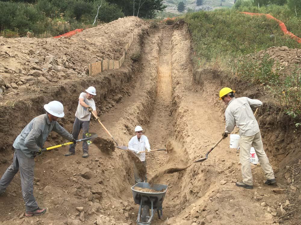
Today the team spent most of the time cleaning out the trench of large debris. This work mostly consisted of removing loose rocks, shoveling soil and rocks, and hauling it out of the trench with a wheelbarrow. The tarps you see in the photos are to protect the sensitive areas of the trench (near the fault) from rain, which can wash away material.


We also acquired a leaf blower to blow off the finer material (silt) from the face of the trench wall. We will continue “leaf blowing” tomorrow and doing more minor touch up before we start photographing for a trench mosaic.
Today we were joined by collaborators Dean Ostenna (Ostenna Geologic, Dillon, CO) and Mark Zellman (BGC, Lakewood, CO).
Day 5: September 9, 2017

Weekend? What weekend? Today we continued to clean out the trench by shoveling out soil and rock into a wheelbarrow and dumping it out away from the trench. We estimate that today we moved about 30 wheelbarrows full of rock and soil. That converts to about more than two tons of material moved, just today! We also did a fair amount of “leaf blowing” before photographing the trench.

In order to photograph the entire trench wall, a bunch of side-by-side photographs are taken and then “stitched together” into a photomosaic. In order to align the final photomosaic and to keep it from “warping” over long distances, control points are surveyed first. Ultimately we will use the photomosaics of the trench to log observations of the trench walls (e.g. different soil/rock units, faults, displacements, sample locations, etc.).
We also set up a few level lines to reference while in the trench and when we view the photomosaics. With a long, steep trench the ground can act like an optical illusion, so true level is different from what "looks" level to your brain. We have been joking about the trench acting like the Mystery Spot in Santa Cruz because when you string up a level line, it looks very, very off, as if it's back tilted into the hill. We even had to bring out an old fashioned bubble level to compare to the total station survey measurements to confirm that it was correct!

Most of the time we have been here is has been very smoky with fairly stagnant air. Today it was breezy and partially cloudy, and the smoke cleared for the first time all week and we could see all the way across the valley. It's a great view! We have many visitors from locals and tourists that have been hiking and biking the nearby trails. Most people seem pretty interested to learn how we study past earthquakes.
The team could not resist making speculation about the number of earthquakes visible in the trench, and we are excited to begin interpretation. We have a late night building the 3D photo model of the trench exposure that will be used to log the trench information.
Today we were joined by Nicole Cholewinski from Golden (NAGT intern with USGS), Jamey Turner and Dan O'Connell (Tetra Tech).

Day 6: September 10, 2017

No rest for the weary. Today, Sunday, we started out by making flags (small pieces of colored flagging on nails). We use color coded flags to outline different rock or soil units, faults, structures, etc. After we made flags we started pinning, where we add the flags along the areas of interest. In the photos this usually looks like a bunch of people standing or sitting around, but there's usually a lot of discussion happening as well.


We spent most of the day pinning and sorting out details in the wall. These interpretations usually end up changing many times over the lifetime of the trench until all the observations are reconciled and any problems get sorted out.
Nicole and I also surveyed control points with GPS, description in photo caption. Ryan and Chris continued to work on the photomosaics and prepped them for trench logs.
I forgot to post the video of “leaf-blowing” the silt off the trench walls yesterday, so be sure to check that out at the bottom of the Day 5 entry! Photos by Jaime Delano, USGS, unless otherwise noted.

Day 7: September 11, 2017

As large as the trench is up-close, it blends in with the rest of the slope on Jackson Hole Mountain Resort from a distance, impressive considering its size and the fact that it's surrounded by orange fencing.


Today was "trash day”. We emptied out the debris that has been slowly accumulating at the base of the trench. That translates to hoeing sediment into a pile, filling buckets, and wheelbarrowing it out, followed by more leaf blowing and brushing.
After that, we spent the rest of the field day pinning flags on the trench walls and discussing what information we think we can glean from the trench. We're starting to dive into the details now that we've had a day to take in the basics.
Today we were visited by the JHMR engineers that we’ve been coordinating the trench logistics with. Chris gave them the tour of the trench. We were also joined today by Adam Hiscock of the Utah Geological Survey.
We spotted several young deer on the way to the trench this morning. Yesterday we saw a young moose chomping on vegetation down closer to the resort.
Day 8: September 12, 2017


After the daily hike up the slope to the trench, we continued to pin units and structures in the trench walls and debated possible interpretations. Now that we are farther along, we try to work through the processes that could form the deposits and stratigraphic relationships we see. The Introduction to Paleoseismology webpage is a good explanation of what we’ll be doing in the trench for the next week or so.
At the end of the day we covered the faulted part of the trench with plastic sheets and tarps in case it rains tonight. Rain can be particularly damaging if it's able to flow off the edges of the trench or the benches because it can scour away material. We expect it to begin to storm any day now, so there's a sense of urgency to use as much of the day during good weather as we can before our luck turns.


Day 9: September 13, 2017


Fall is definitely in the air, which means the aspen leaves are turning, but so is the weather. Today was the last push during decent weather before the significant rain arrives. After spending most of the day working out interpretations, we removed more material from the trench that had been accumulating over the last few days so that it doesn't turn to mud with the coming rain. We hope to fit in a few hours of sketching on trench logs tomorrow morning before the next wave of rain hits.
In the afternoon we were joined by Kate Scharer and Devin McPhillips of USGS in Pasadena, California. The team gave Kate and Devin a quick overview and brought them up to speed on the work we've done so far. Not long after that introduction the weather turned, but we were ready with the tarps and plastic sheeting. It was a quick team effort to prep the trench right before the heavy downpour started.

Day 10: September 14, 2017


We’re narrowing in on the interpretation of the trench walls with the newly-added help of Kate and Devin. Fresh eyes are key during this process because they keep the discussion moving in new directions and provide new perspective.
Today we kept dodging the rain squalls, so we had to take brief breaks during heavy rain. We have to vacate the trench during rain for two main reasons: 1) The water obscures the trench walls and smears the silt, and 2) significant water can cause instability in sediment walls, making it potentially unsafe to remain in the trench.

Day 11: September 15, 2017

It was a bit miserable with rain off and on throughout the day, and it was also noticeably colder. Up to this point it's been fairly hot - sometimes a little too hot- but today we put on all of our layers to hunker down and dig into some details of the interpretations.


Once it was dry enough to visit the trench, we gave an overview to Glenn Thackray, Nick Patton and Carl (all from Idaho State University) and visiting scientists Andrea Hampel (University of Hannover, Germany) and Ralph Hetzel from (University of Muenster, Germany). We were joined later in the day by Bob Smith (Emeritus at University of Utah) and John Byrd, who previously conducted a trench investigation of the Teton Fault at Granite Canyon north of this location.
Most of the rest of the day was occupied with completing the trench logs. We print out pieces of the photomosaics and tape them to rigid artboards, then cover them in Dura-lar (transparent plastic). We log the interpretations directly on to the Dura-lar so that the printed photos stay dirt- and moisture-free
We still have a bit of work to do with the trench logs, especially in the areas that are still being debated. Tomorrow looks like another cold day.
Day 12: September 16, 2017

This morning we woke up to wet snow falling, so we got a little bit of a later start at the trench. The team split up and investigated a few nearby geologic-sites-of-interest while we waited for the precipitation to pass.
After spending the day yesterday logging the trench we realized there were a few areas in the trench that we needed to revisit and discuss. The field day was mostly spent adding finishing touches to the trench logs and sorting out any lingering discrepancies. A few times we had to remove rocks near the trench bench to connect the stratigraphy between the lower and upper trench walls.
Today we were joined by Darren Larson (Occidental College) and Seth Witke (Wyoming Geologic Survey).


Day 13: September 17, 2017


Today was an exciting day for wildlife viewing! In the morning Andrea and Ralph spotted a moose with a large set of antlers, and Rich spotted the (probably) same moose on the way down from the trench in the evening!
Up until now there have only been spotty sightings of a young moose without antlers. We also spotted two bears (a mama bear and a baby bear) munching on berries near the trench site. It was very exciting to watch from a respectful distance.
On the science side, most of today was spent sampling. In this trench, we are sampling for radiocarbon dating and optically stimulated luminescence (OSL) dating. We target sediment units that are critical to constraining the timing of large past earthquakes that broke the ground surface. For example, if we take a sample from the youngest layer that was offset in the earthquake, and then another sample from the layer that was deposited after the earthquake, we can get minimum and maximum ages of the earthquake offset.


Day 14: September 18, 2017


Today was a race against the clock to finish collecting samples before a new wave of rain and snow arrives. We finished collecting radiocarbon and OSL samples and collected a few more photos for our records. We also took unit descriptions where we record things like grain size distribution, clast rounding, color (using a special soil color book), and internal structure/characteristics.
For a few OSL samples, we weren't able to get the sample tube into the trench wall because there were too many large rocks in the way. OSL samples are sensitive to light exposure, so an alternate method of sample collecting is to use tarps to shield the wall from sunlight and collect in the dark. Chris collected a few samples under the tarps using a red headlamp to see. Red light has a long enough wavelength that it won't reset the OSL samples.
Day 15: September 19, 2017
It was a chilly day. The precipitation was mostly graupel, or soft hail, which was kind of a unique weather experience, and it continued all day. Today was the final workday at the trench. We cleaned up the site by removing the fencing, plywood, nails, plastic, and other materials we've been using. After clearing out the trench, Ryan and Chris flew the UAVs (drones) around the trench site. We’re hoping to create a 3D model with the photos, but we aren't sure yet how the graupel will affect the picture quality. Either way, we got a few good photos of the site from the air.
Tomorrow morning is an “open trench” event for the media (meaning the trench will be visible). Due to time and safety constraints media will not be able to enter the trench. Then the excavator will return and fill the trench back in. By the first good snow you won't even know we were here!


Day 16: September 20, 2017

Today was our final day in Teton Village. After packing up the field vehicle, Chris and Jaime met with a members of the Nation Forest Service, Jackson Hole Mountain Resort, and local members of the media to discuss our Teton fault research while watching the excavator fill in the trench from a safe distance. Afterward Chris spoke on the phone with a local NPR journalist, and then we hit the road!
We will arrive back in Golden tomorrow, and I'll give one more daily update with some more information about the work that follows. The field work part of the study is really only about 50% of the work, and there's still plenty to do once we get back to the office.
Day 17: September 21, 2017

The next, and arguably most important, step is to submit the radiocarbon and OSL (optically stimulated luminescence) samples (see Day 13 for details) to the laboratories. For the radiocarbon samples, a lab in Massachusetts will separate out the bits of charcoal and identify the plant species they come from. We try to avoid plant sample types like hardwood because it can stick around in the landscape for long periods of time and is less precise for dating. The OSL samples will be be processed in Denver at a USGS lab. The sediment will be sieved down to fine sand and separated so only the quartz minerals remain, then analyzed for the luminescence signal. The radiocarbon results usually take several months (or more) until age results are returned, and the OSL can take about 6 month to a year for results.
The age results are a very important part of the data collection because they will constrain when the earthquakes occurred. We can use these data (along with data from other trenches) to determine how often these large (greater than magnitude 6.5) earthquakes occur, how much vertical slip they generated, and which parts of the fault are rupturing in each event. For example, if 3 different trenches show evidence for the same earthquake, we can estimate that the rupture length was large enough to span all 3 sites. If an earthquake only shows up in one trench, it may have been a much shorter rupture length. Ultimately, the rupture length along the fault is related to the earthquake magnitude and how much shaking it produces. Information from studies like this inform seismic hazard maps, which are used to guide building codes in areas that might experience strong shaking. You can read our Introduction to Paleoseismology webpage for more details about the whole process.
This study was by far the most comprehensive look at the Teton fault to date. We will combine these results with data from two smaller hand dug trenches near the center and northern end of the Teton fault (dug by the same Teton team), as well as data from a Teton trench dug about 30 years ago. Modern advancements in technology, such as improved dating techniques, lidar, photography, and 3D modelling have really changed paleoseismic studies for the better over the last few years/decades.
Aside from age results, we will be sorting though all the other data collected. Chris will be digitizing the trench logs for further analysis and ultimately publication.