Untangling Faults at Depth – What Lies Beneath Panamint Valley, California?
Release Date: APRIL 30, 2018
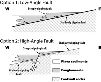
The eastern edge of Panamint Valley,CA has two types of faults that can be seen in the near-surface geology. 150 geophones and a seismic source will help reveal the subsurface picture.

Panamint Valley in southern California stretches out across the horizon like a photo from the surface of Mars.USGS scientists, along with colleagues from Oregon State University and University of Kentucky, will be surveying along the quiet roads in this remote area on the southwestern edge of Death Valley National Park on April 23 to May 4 in an effort to figure out what type of fault is active there.
The eastern edge of Panamint Valley has two types of faults that can be seen in the near-surface geology: low-angle faults at the mountain front and high-angle faults in the valley. To determine which type of fault is active there, the scientists must understand how these faults move deep below the surface. The answer will ultimately reveal whether faults in the region can break in complex combinations of low- and high-angle faults, or if one or the other of these is most likely to rupture alone.

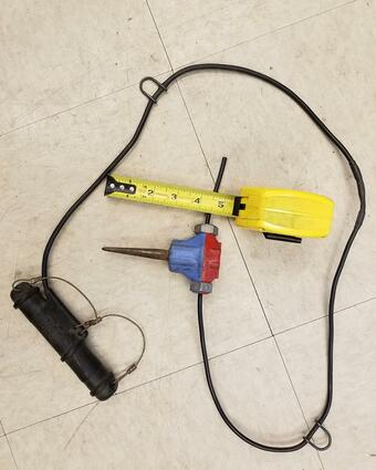
To get a picture of what’s going on 500 ft below the surface, the team of scientists will use 150 geophones and a seismic source. The geophones are extremely sensitive sensors that will record the shaking produced by the seismic source. The seismic source, or “mini-vibe,” is a 3-ton vibrator pulled on trailer behind a truck. It shakes the ground enough for the sensors to record the signal, but 20 ft beyond the mini-vibe, a person can barely feel the shaking.
The scientists will push the 150 geophones 3 inches into the ground along the side of the road, and then the mini-vibe will move down the road, stopping every 15 ft to shake the ground. When the crew reaches the end of the line of geophones, they’ll remove them and place them along the next 1-mile stretch, and then continue with the mini-vibe. The survey will cover a total of about 3.5 miles by shaking, recording, and then leap-frogging with the geophones. When all the data are put together from all the shakes at all the geophones, the result is a seismic reflection profile, a picture of the subsurface much like an ultrasound. Scientists hope the seismic-reflection “pictures” will reveal the position of the faults below the surface.
The position of the faults will indicate the potential strength and distribution of ground-shaking during an earthquake. This information is used to make the National Seismic Hazard Maps, which are updated with the latest information every few years. These hazard maps are used by engineers to determine the best building codes for different areas based on how hard and how often the ground shakes. The building codes guide the construction standards for houses, bridges, and other structures to withstand earthquake shaking without collapsing or causing injuries to those inside or nearby. Despite its remote location, the Panamint Valley tectonic setting is very similar to the Wasatch Valley where the population is substantial. The results from the Panamint area study will be applicable to the Wasatch area and will help inform scientists about the likely hazard there and the risks it may pose to the population and infrastructure.
-written by Lisa Wald, U.S. Geological Survey
For More Information
- Faults, Earthquake Geology, and Special Earthquake Studies
- Seismic Hazard Maps and Site-Specific Data


The Scientist Behind the Science

Bill Stephenson (the crew leader) has been a research geophysicist with the USGS for 27 years. His research focuses on characterizing earthquake hazards and understanding ground motion amplification in urbanized regions through high-resolution seismic imaging. He spends as much time as he can in the outdoors hiking, biking, skiing, fishing, and hunting.
Other crew members include USGS scientists Ryan Gold, Rich Briggs, Chris DuRoss, and Jaime Delano, and cooperators Eric Kirby (Oregon State University), and Ed Woolery (University of Kentucky).
Below are partners associated with this project.
Release Date: APRIL 30, 2018
The eastern edge of Panamint Valley,CA has two types of faults that can be seen in the near-surface geology. 150 geophones and a seismic source will help reveal the subsurface picture.

Panamint Valley in southern California stretches out across the horizon like a photo from the surface of Mars.USGS scientists, along with colleagues from Oregon State University and University of Kentucky, will be surveying along the quiet roads in this remote area on the southwestern edge of Death Valley National Park on April 23 to May 4 in an effort to figure out what type of fault is active there.
The eastern edge of Panamint Valley has two types of faults that can be seen in the near-surface geology: low-angle faults at the mountain front and high-angle faults in the valley. To determine which type of fault is active there, the scientists must understand how these faults move deep below the surface. The answer will ultimately reveal whether faults in the region can break in complex combinations of low- and high-angle faults, or if one or the other of these is most likely to rupture alone.

To get a picture of what’s going on 500 ft below the surface, the team of scientists will use 150 geophones and a seismic source. The geophones are extremely sensitive sensors that will record the shaking produced by the seismic source. The seismic source, or “mini-vibe,” is a 3-ton vibrator pulled on trailer behind a truck. It shakes the ground enough for the sensors to record the signal, but 20 ft beyond the mini-vibe, a person can barely feel the shaking.
The scientists will push the 150 geophones 3 inches into the ground along the side of the road, and then the mini-vibe will move down the road, stopping every 15 ft to shake the ground. When the crew reaches the end of the line of geophones, they’ll remove them and place them along the next 1-mile stretch, and then continue with the mini-vibe. The survey will cover a total of about 3.5 miles by shaking, recording, and then leap-frogging with the geophones. When all the data are put together from all the shakes at all the geophones, the result is a seismic reflection profile, a picture of the subsurface much like an ultrasound. Scientists hope the seismic-reflection “pictures” will reveal the position of the faults below the surface.
The position of the faults will indicate the potential strength and distribution of ground-shaking during an earthquake. This information is used to make the National Seismic Hazard Maps, which are updated with the latest information every few years. These hazard maps are used by engineers to determine the best building codes for different areas based on how hard and how often the ground shakes. The building codes guide the construction standards for houses, bridges, and other structures to withstand earthquake shaking without collapsing or causing injuries to those inside or nearby. Despite its remote location, the Panamint Valley tectonic setting is very similar to the Wasatch Valley where the population is substantial. The results from the Panamint area study will be applicable to the Wasatch area and will help inform scientists about the likely hazard there and the risks it may pose to the population and infrastructure.
-written by Lisa Wald, U.S. Geological Survey
For More Information
- Faults, Earthquake Geology, and Special Earthquake Studies
- Seismic Hazard Maps and Site-Specific Data


The Scientist Behind the Science

Bill Stephenson (the crew leader) has been a research geophysicist with the USGS for 27 years. His research focuses on characterizing earthquake hazards and understanding ground motion amplification in urbanized regions through high-resolution seismic imaging. He spends as much time as he can in the outdoors hiking, biking, skiing, fishing, and hunting.
Other crew members include USGS scientists Ryan Gold, Rich Briggs, Chris DuRoss, and Jaime Delano, and cooperators Eric Kirby (Oregon State University), and Ed Woolery (University of Kentucky).
Below are partners associated with this project.

