Anaerobic processing of sediment prior to geochemical analyses.
Anaerobic processing of sediment prior to geochemical analyses.A scientist completes anaerobic processing of sediment from selected core depths prior to geochemical analyses.


Official websites use .gov
A .gov website belongs to an official government organization in the United States.

Secure .gov websites use HTTPS
A lock () or https:// means you’ve safely connected to the .gov website. Share sensitive information only on official, secure websites.

All items in this gallery are considered public domain unless otherwise noted.

A scientist completes anaerobic processing of sediment from selected core depths prior to geochemical analyses.
A scientist completes anaerobic processing of sediment from selected core depths prior to geochemical analyses.

To help understand the geochemical conditions that control arsenic mobilization in the subsurface a U.S. Geological Survey scientist uses a syringe to withdraw water from a core for analysis.
To help understand the geochemical conditions that control arsenic mobilization in the subsurface a U.S. Geological Survey scientist uses a syringe to withdraw water from a core for analysis.

To help understand the geochemical conditions that control arsenic mobilization in the subsurface a USGS scientist uses a syringe to withdraw water from a core for analysis.
To help understand the geochemical conditions that control arsenic mobilization in the subsurface a USGS scientist uses a syringe to withdraw water from a core for analysis.

Tundra swans that nest in Alaska are exposed to lead on their wintering grounds along the Atlantic Coast.
Tundra swans that nest in Alaska are exposed to lead on their wintering grounds along the Atlantic Coast.

USGS scientists collecting soil samples at Canyon Mine.
USGS scientists collecting soil samples at Canyon Mine.

U.S. Geological Survey (USGS) scientists collecting soil samples on the Canyon Mine property, Arizona. The mine's headframe and mine workshop are visible in the background.
U.S. Geological Survey (USGS) scientists collecting soil samples on the Canyon Mine property, Arizona. The mine's headframe and mine workshop are visible in the background.

Chesapeake Bay watershed, outlined in blue. Modified from USGS poster.The Chesapeake Bay Watershed.
Chesapeake Bay watershed, outlined in blue. Modified from USGS poster.The Chesapeake Bay Watershed.

Illustration showing examples of environmental contaminant source and transport pathways. This illustration is a higher resolution version of figure 4 of USGS Circular 1383-E and figure 1 of USGS Open-file Report 2015-1113.
Illustration showing examples of environmental contaminant source and transport pathways. This illustration is a higher resolution version of figure 4 of USGS Circular 1383-E and figure 1 of USGS Open-file Report 2015-1113.

Illustration showing examples of infectious disease transmission pathways. This illustration is a higher resolution version of figure 5 of USGS Circular 1383-E.
The illustration visually conveys the following environmental health priority topics of study:
Illustration showing examples of infectious disease transmission pathways. This illustration is a higher resolution version of figure 5 of USGS Circular 1383-E.
The illustration visually conveys the following environmental health priority topics of study:

Spigot sticking out of a pipe in a drinking-water treatment plant
Spigot sticking out of a pipe in a drinking-water treatment plant
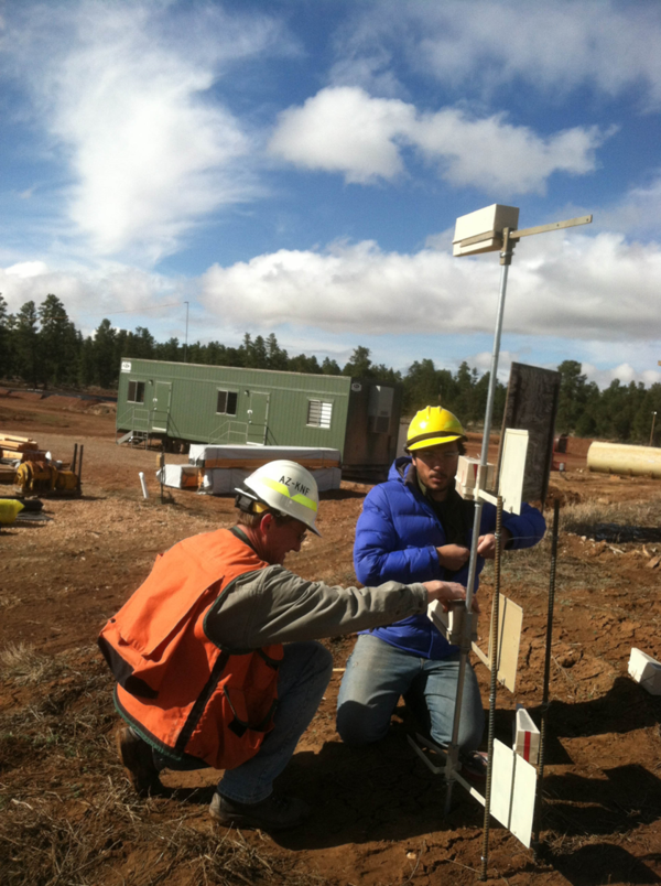
USGS and USFS scientists installing dust collectors at the Pinyon Plain uranium mine. Photo: Mike Duniway. 4/9/2013.
USGS and USFS scientists installing dust collectors at the Pinyon Plain uranium mine. Photo: Mike Duniway. 4/9/2013.

Wellhead inside of a drinking-water plant

A USGS scientist collecting a water-quality sample from Boulder Creek, Colorado.
A USGS scientist collecting a water-quality sample from Boulder Creek, Colorado.

Left: USGS Employee L. Windham-Myers showing a surface water sample collected in acid-cleaned mason jar (deployed for 24 hours) for a mercury study conducted at the Cosumnes River Nature Preserve (CA). Photographer: M. Marvin-DiPasquale. Date: 10/29/2014.
Left: USGS Employee L. Windham-Myers showing a surface water sample collected in acid-cleaned mason jar (deployed for 24 hours) for a mercury study conducted at the Cosumnes River Nature Preserve (CA). Photographer: M. Marvin-DiPasquale. Date: 10/29/2014.

A U.S. Geological Survey analyst performs DNA extractions on enriched cultures of water from the study area. Once the DNA was extracted it was used to detect pathogen gene markers using polymerase chain reaction (PCR).
A U.S. Geological Survey analyst performs DNA extractions on enriched cultures of water from the study area. Once the DNA was extracted it was used to detect pathogen gene markers using polymerase chain reaction (PCR).

USGS Scientist collecting a water-quality sample from the South Fork Zumbro River, MN
USGS Scientist collecting a water-quality sample from the South Fork Zumbro River, MN

USGS scientists recording information on water-quality samples and field water-quality parameters
USGS scientists recording information on water-quality samples and field water-quality parameters

Bacteria contained in filter chambers placed in downgradient observation wells were exposed to sulfamethoxazole for 30 days as it traveled past the wells
Bacteria contained in filter chambers placed in downgradient observation wells were exposed to sulfamethoxazole for 30 days as it traveled past the wells

Microbial-Contaminant Interactions Laboratory — Boulder, Colorado. Bacteria contained in filter chambers placed in downgradient observation wells were exposed to sulfamethoxazole for 30 days as it traveled past the wells.
Microbial-Contaminant Interactions Laboratory — Boulder, Colorado. Bacteria contained in filter chambers placed in downgradient observation wells were exposed to sulfamethoxazole for 30 days as it traveled past the wells.

Picture of a dead Green Winged Teal (Anas carolinensis) covered with algae in Chesapeake Bay.
Picture of a dead Green Winged Teal (Anas carolinensis) covered with algae in Chesapeake Bay.

Algae near the shore of Poplar Island-a 3-mile-long (4.8-kilometer-long) island located on the Chesapeake Bay, part of Talbot County, Maryland.
Algae near the shore of Poplar Island-a 3-mile-long (4.8-kilometer-long) island located on the Chesapeake Bay, part of Talbot County, Maryland.