
Navigating PFAS Contamination: Insights from the USGS Potomac River Watershed Study
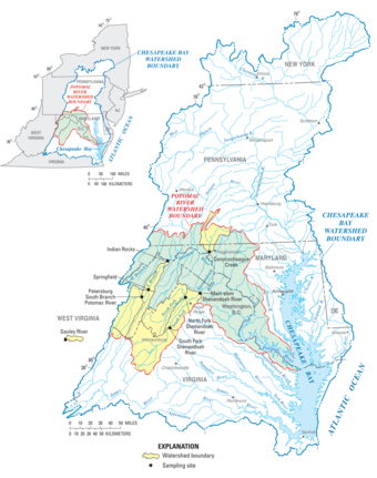
The Potomac River is a major watershed in the eastern United States that serves as a crucial water supply for millions of people. USGS researchers conducted a comprehensive investigation to identify the contributions of municipal and industrial wastewater treatment plant effluent to the levels of per-and polyfluoroalkyl substances (PFAS) in the Potomac River. This study included measuring PFAS levels through sampling, analyzing their potential sources, creating models to understand how water flows and how people and wildlife may be exposed, and assessing health risks to both humans and the environment.
Per- and polyfluoroalkyl substances (PFAS), often referred to as "forever chemicals," are persistent pollutants that pose risks to human health and the environment. These man-made chemicals are extensively used in various industries and consumer products, and they frequently end up in wastewater. Traditional wastewater treatment methods, including primary and secondary treatment, are largely ineffective at removing PFAS, resulting in potential contamination of surface waters from treated effluent. This situation presents additional water management challenges in water bodies that serve as sources for drinking water while also receiving treated wastewater.
Identifying the Sources of PFAS
A recent study by the USGS focused on understanding the sources of PFAS in the Potomac River watershed in the eastern United States. Researchers developed models designed to predict where PFAS might be present and identify areas at higher risk of contamination from wastewater discharges.
Modeling results from the study revealed that many parts of the Potomac River were impacted by a mix of PFAS from both municipal and industrial wastewater discharges, as well as other sources. Eight specific PFAS were commonly found in the effluents of municipal wastewater treatment plants. The amount of PFAS in each stream varied depending on the characteristics of the stream itself. By linking their modeling approach to the USGS stream-gage network, the researchers predicted PFAS concentrations over time, enhancing the ability to monitor water quality. While the measured and predicted PFAS levels in the streams were generally below harmful thresholds for aquatic life, some levels approached or exceeded safe limits for drinking water and fish consumption.
Data Analysis Tools
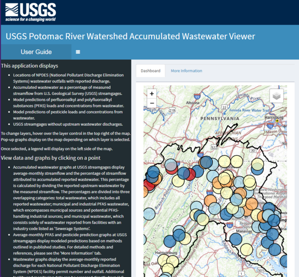
USGS created a geospatial tool and map viewer for the Potomac River watershed that performs several important functions:
- Streamflow Contribution: It calculates the percentage of streamflow that comes from upstream municipal and industrial wastewater treatment plant discharges for specific stream segments.
- PFAS Concentration Prediction: The tool predicts concentrations of eight different PFAS compounds in these stream segments.
- Public Supply Water Estimates: It estimates the range of PFAS concentrations in the waters used for public supply.
- Vulnerability Scoring: The tool provides vulnerability scores to help rank the potential risks of PFAS contamination for different stream segments.
The USGS Potomac River Watershed Accumulated Wastewater Viewer is a comprehensive tool that was designed to assist in better understanding and managing PFAS risks in the Potomac River watershed.
Management Implications
This study provides valuable tools to understand how people and aquatic organisms might be exposed to PFAS. The models created can help estimate PFAS concentrations in public water supplies, considering both time and water flow conditions, which could serve as an early warning system for concentrations that are close to regulatory limits. By identifying areas of concern for PFAS contamination, this watershed-wide approach can also direct future research efforts. This study underscores the need for comprehensive monitoring and management strategies as PFAS contamination poses an ongoing challenge for water quality across the Potomac River Basin. As awareness of exposure to PFAS grows, tools like these will be essential for ensuring safe drinking water and protecting the ecological health of our waterways.
The Potomac River watershed is a major geographical and ecological area spanning approximately 14,670 square miles, and encompassing parts of Maryland, Virginia, West Virginia, Pennsylvania, and Washington, D.C. It supports diverse ecosystems, including forests, wetlands, and wildlife habitats and provides recreational opportunities and water resources for millions of residents.
This work was funded by the USGS Ecosystem Mission Area Environmental Health Program and Chesapeake Bay Program; and the USGS Water Mission Area Water Quality Processes Program Proxies Project.
The Potomac River is a major watershed in the eastern United States that serves as a crucial water supply for millions of people. USGS researchers conducted a comprehensive investigation to identify the contributions of municipal and industrial wastewater treatment plant effluent to the levels of per-and polyfluoroalkyl substances (PFAS) in the Potomac River. This study included measuring PFAS levels through sampling, analyzing their potential sources, creating models to understand how water flows and how people and wildlife may be exposed, and assessing health risks to both humans and the environment.
Per- and polyfluoroalkyl substances (PFAS), often referred to as "forever chemicals," are persistent pollutants that pose risks to human health and the environment. These man-made chemicals are extensively used in various industries and consumer products, and they frequently end up in wastewater. Traditional wastewater treatment methods, including primary and secondary treatment, are largely ineffective at removing PFAS, resulting in potential contamination of surface waters from treated effluent. This situation presents additional water management challenges in water bodies that serve as sources for drinking water while also receiving treated wastewater.
Identifying the Sources of PFAS
A recent study by the USGS focused on understanding the sources of PFAS in the Potomac River watershed in the eastern United States. Researchers developed models designed to predict where PFAS might be present and identify areas at higher risk of contamination from wastewater discharges.
Modeling results from the study revealed that many parts of the Potomac River were impacted by a mix of PFAS from both municipal and industrial wastewater discharges, as well as other sources. Eight specific PFAS were commonly found in the effluents of municipal wastewater treatment plants. The amount of PFAS in each stream varied depending on the characteristics of the stream itself. By linking their modeling approach to the USGS stream-gage network, the researchers predicted PFAS concentrations over time, enhancing the ability to monitor water quality. While the measured and predicted PFAS levels in the streams were generally below harmful thresholds for aquatic life, some levels approached or exceeded safe limits for drinking water and fish consumption.
Data Analysis Tools
USGS created a geospatial tool and map viewer for the Potomac River watershed that performs several important functions:
- Streamflow Contribution: It calculates the percentage of streamflow that comes from upstream municipal and industrial wastewater treatment plant discharges for specific stream segments.
- PFAS Concentration Prediction: The tool predicts concentrations of eight different PFAS compounds in these stream segments.
- Public Supply Water Estimates: It estimates the range of PFAS concentrations in the waters used for public supply.
- Vulnerability Scoring: The tool provides vulnerability scores to help rank the potential risks of PFAS contamination for different stream segments.
The USGS Potomac River Watershed Accumulated Wastewater Viewer is a comprehensive tool that was designed to assist in better understanding and managing PFAS risks in the Potomac River watershed.
Management Implications
This study provides valuable tools to understand how people and aquatic organisms might be exposed to PFAS. The models created can help estimate PFAS concentrations in public water supplies, considering both time and water flow conditions, which could serve as an early warning system for concentrations that are close to regulatory limits. By identifying areas of concern for PFAS contamination, this watershed-wide approach can also direct future research efforts. This study underscores the need for comprehensive monitoring and management strategies as PFAS contamination poses an ongoing challenge for water quality across the Potomac River Basin. As awareness of exposure to PFAS grows, tools like these will be essential for ensuring safe drinking water and protecting the ecological health of our waterways.
The Potomac River watershed is a major geographical and ecological area spanning approximately 14,670 square miles, and encompassing parts of Maryland, Virginia, West Virginia, Pennsylvania, and Washington, D.C. It supports diverse ecosystems, including forests, wetlands, and wildlife habitats and provides recreational opportunities and water resources for millions of residents.
This work was funded by the USGS Ecosystem Mission Area Environmental Health Program and Chesapeake Bay Program; and the USGS Water Mission Area Water Quality Processes Program Proxies Project.