



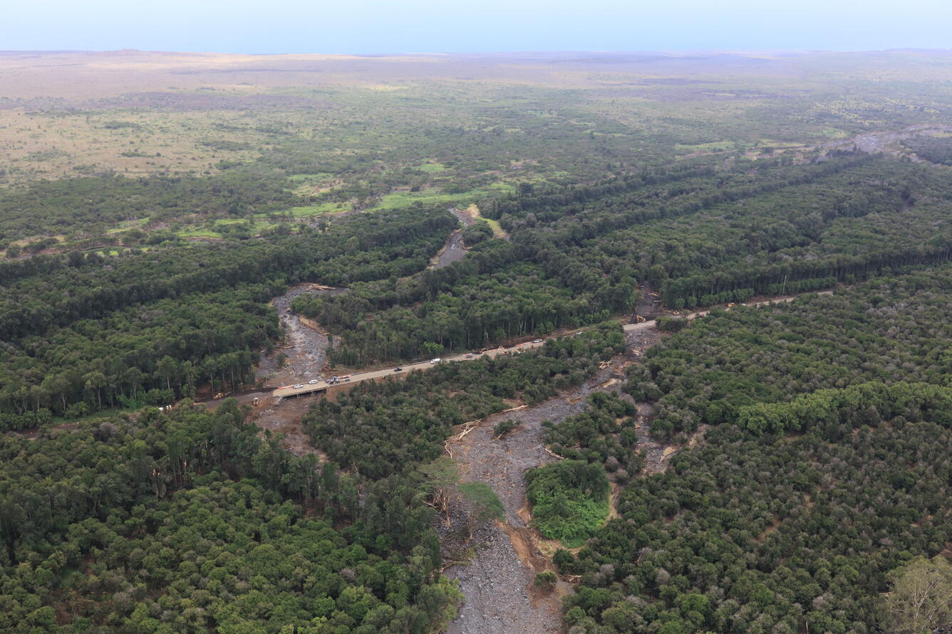
Flooding and debris flows occurred on the south side of Hawai‘i Island during Hurricane Lala, which passed near the island on 15 –17 August 2026. The hurricane produced high rainfall rates, (e.g., 32.1 inches of daily rainfall recorded at the Laupāhoehoe station) (University of Hawai’i News, 2026). Catastrophic flash flooding, debris flows following the storm, specifically near Na‘ālehu, and Waiohinu, damaged infrastructure and resulted in two known fatalities. Helicopter imagery obtained from the USGS Hawaiian Volcano Observatory provided rapid observations of on-the-ground erosion/sedimentation. It appears that the debris flow activity was largely runoff-generated primarily in steep-incised gullies on the island (Kellefer & Raby, 2026).
This landslide event page serves as an event summary to communicate timely science information to our partners. This information includes what is currently understood about the event and ongoing activities of the USGS and partner agencies and may be subject to change.
Our thoughts go out to everyone affected by 2026 Hurricane Lala Landslide Hazards and the significant flooding and landslide activity that continues to impact the region.
Field Photos | Observations | More Information | Publications
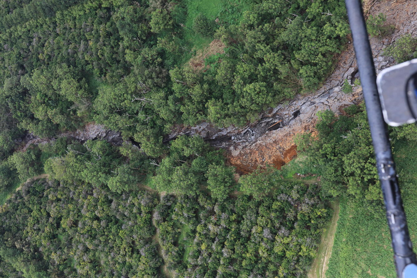
- How it started: Steep entrenched gullies with abundant soil/rock.
- What made it worse: The gully entrenchment creates vertical erosion and many cliffs/steps/knickpoints allowed the flow to gain energy.
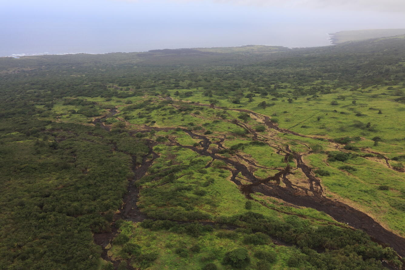
- Where did we see deposition: When the flow exited the entrenched channels and lost confinement there was rapid deposition. Also, there is some evidence of flow blockage a culverts or road underpasses that also resulted in deposition.
- What was the impact: Evidence of both building burial in slow moving flow areas as well as total building destruction.
Field Photos
Contributors to this page include Ben Mirus, Francis Rengers, Michael Zoeller, and Marísa Macías.
Learn more about landslides.
Learn more about landslide preparedness.
Learn more about the National Landslide Susceptibility Map.
Learn more about the Landslide Hazards Program.
Learn more about USGS Landslide Response.
References
1 University of Hawaiʻi News, 2026, Hurricane Lala douses Hawaiʻi with 1.9M Olympic-size pools of water, https://www.hawaii.edu/news/2026/08/20/hurricane-lala/
2 Kellefer, J.S., Raby, J., 2026, Former teacher, 93, among the deaths blamed on storm as Hawaii residents struggle to clean up: AP News, https://apnews.com/article/hurricane-lala-tropical-weather-94388afddd817481b513d9d1fbe8662b
| Disclaimer: This information is preliminary or provisional and is subject to revision. It is being provided to meet the need for timely best science. The information has not received final approval by the U.S. Geological Survey (USGS) and is provided on the condition that neither the USGS nor the U.S. Government shall be held liable for any damages resulting from the authorized or unauthorized use of the information. |
Landslide Safety
Landslide Preparedness
Flooding and debris flows occurred on the south side of Hawai‘i Island during Hurricane Lala, which passed near the island on 15 –17 August 2026. The hurricane produced high rainfall rates, (e.g., 32.1 inches of daily rainfall recorded at the Laupāhoehoe station) (University of Hawai’i News, 2026). Catastrophic flash flooding, debris flows following the storm, specifically near Na‘ālehu, and Waiohinu, damaged infrastructure and resulted in two known fatalities. Helicopter imagery obtained from the USGS Hawaiian Volcano Observatory provided rapid observations of on-the-ground erosion/sedimentation. It appears that the debris flow activity was largely runoff-generated primarily in steep-incised gullies on the island (Kellefer & Raby, 2026).
This landslide event page serves as an event summary to communicate timely science information to our partners. This information includes what is currently understood about the event and ongoing activities of the USGS and partner agencies and may be subject to change.
Our thoughts go out to everyone affected by 2026 Hurricane Lala Landslide Hazards and the significant flooding and landslide activity that continues to impact the region.
Field Photos | Observations | More Information | Publications
- How it started: Steep entrenched gullies with abundant soil/rock.
- What made it worse: The gully entrenchment creates vertical erosion and many cliffs/steps/knickpoints allowed the flow to gain energy.
- Where did we see deposition: When the flow exited the entrenched channels and lost confinement there was rapid deposition. Also, there is some evidence of flow blockage a culverts or road underpasses that also resulted in deposition.
- What was the impact: Evidence of both building burial in slow moving flow areas as well as total building destruction.
Field Photos
Contributors to this page include Ben Mirus, Francis Rengers, Michael Zoeller, and Marísa Macías.
Learn more about landslides.
Learn more about landslide preparedness.
Learn more about the National Landslide Susceptibility Map.
Learn more about the Landslide Hazards Program.
Learn more about USGS Landslide Response.
References
1 University of Hawaiʻi News, 2026, Hurricane Lala douses Hawaiʻi with 1.9M Olympic-size pools of water, https://www.hawaii.edu/news/2026/08/20/hurricane-lala/
2 Kellefer, J.S., Raby, J., 2026, Former teacher, 93, among the deaths blamed on storm as Hawaii residents struggle to clean up: AP News, https://apnews.com/article/hurricane-lala-tropical-weather-94388afddd817481b513d9d1fbe8662b
| Disclaimer: This information is preliminary or provisional and is subject to revision. It is being provided to meet the need for timely best science. The information has not received final approval by the U.S. Geological Survey (USGS) and is provided on the condition that neither the USGS nor the U.S. Government shall be held liable for any damages resulting from the authorized or unauthorized use of the information. |