



2026 Southwest Colorado Storm-Triggered Landslides
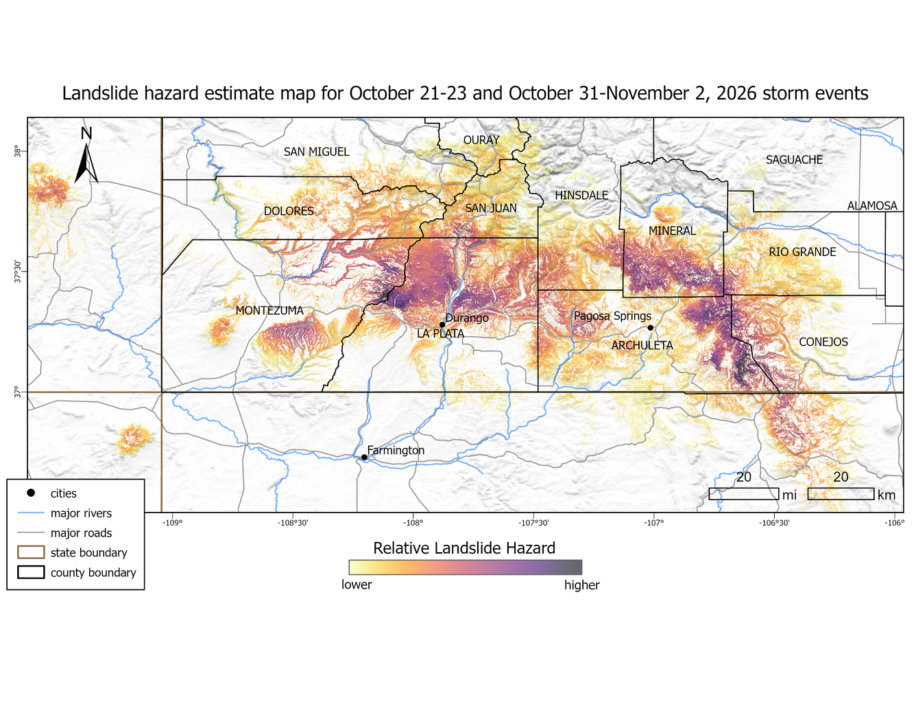
Back-to-back rain events from approximately October 21-23 and October 31-November 2, 2026, caused severe flooding in the “Four Corners” region – the intersection of Arizona, Colorado, New Mexico, and Utah. In Southwest Colorado, the storms resulted in widespread flooding throughout Montezuma, La Plata, Archuleta, Rio Grande, and Conejos counties, and the Ute Mountain and Southern Ute Reservations. Cumulative rainfall for these two events from NOAA’s Multi-Radar/Multi-Sensor System (MRMS) reveals approximately 8.8 inches (220 mm) of rain in Durango, Colorado and 10 inches (250 mm) of rain in Pagosa Springs, Colorado, which surpasses historical monthly and seasonal averages. Preliminary mapping using satellite imagery reveals hundreds of long-runout landslides and debris flows in mountainous regions that contributed mud and debris to flooding downstream.
This landslide event page serves as an event summary to communicate timely science information to our partners. This information includes what is currently understood about the event and ongoing activities of the USGS and partner agencies and may be subject to change.
Our thoughts go out to the people affected by 2026 Southwest Colorado Storm-Triggering Landslides and the flooding that continues to impact the region.
Field Photos | Observations | More Information | Publications
How to stay safe:
- Landslides can still happen for the next few days to weeks, especially with more precipitation. Listen to National Weather Service weather alerts. Follow emergency messages from local authorities.
- Pay attention to the landslide warning signs. Watch for new cracks forming on the ground, leaning trees, new springs, or falling rocks.
- Do not try to clear landslides that are blocking roads without consulting a professional geologist or engineer. Removing material may remobilize the landslide, bringing more material down the hillside. Downed power lines or other hazards may be hidden under the landslide deposit.
- If a landslide impacted your home, or you see signs of a landslide, contact your local emergency services. Local officials are best able to assess potential danger. If the danger is not immediate, seek guidance from a qualified professional engineering geologist or civil engineer.
- Learn more about landslide preparedness.
Landslide Safety
Landslide Preparedness
What we are doing
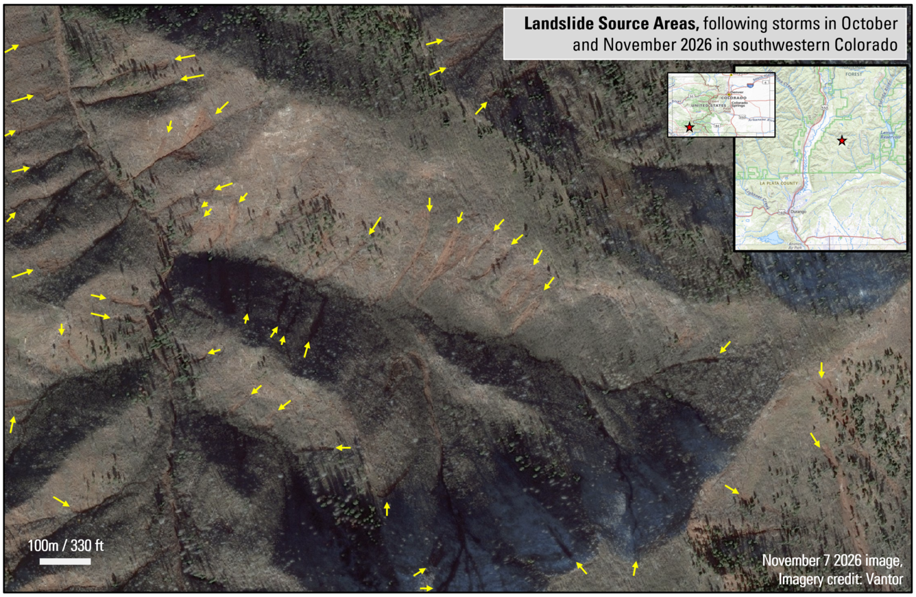
The USGS activated in collaboration with the Colorado Geological Survey (CGS) and Fort Lewis College on November 6th, 2026. The USGS is providing technical assistance through remote, aerial, and field reconnaissance, including mapping landslides using satellite imagery. The focus is providing situational awareness for response and recovery efforts.
Key landslides observations (as of 11/10/2
- High resolution imagery is revealing many landslides in steep canyons along the Animas River Valley corridor and debris flows reaching the mouths of some canyons.
- Satellite imagery shows additional landslides in areas where landslide damage to buildings and infrastructure was already reported, for example at Purgatory Resort and along County Road 250 in La Plata County
- Reports of widespread flooding, large debris flows, and reports of new or ongoing landslides in La Plata County.
- Widespread flooding on reactivated alluvial fans emanating from Hermosa Creek, Tripp Creek, Falls Creek, and Stevens Creek, leaving deposits of mud and sand up several feet thick across a large area.
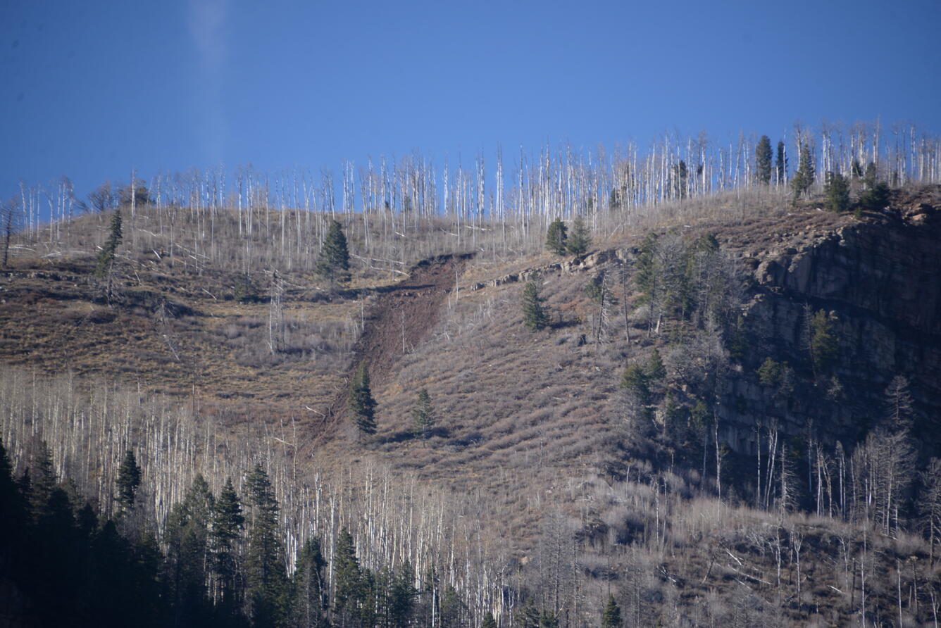
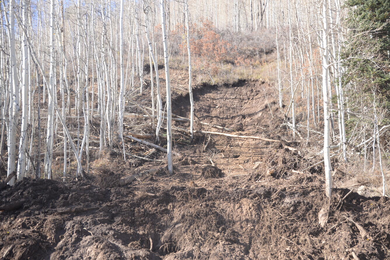
- Widespread debris flows and 'blowouts' in the soil-mantled slopes at mid-elevations.
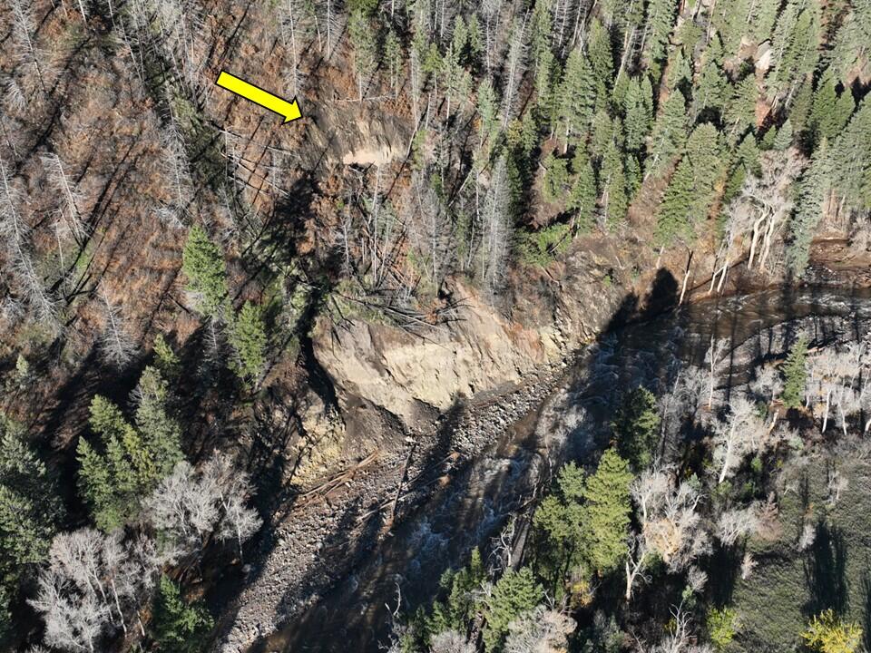
- Deeper, bedrock involved, landslides where fast-moving rivers eroded away the toes of adjacent hillslopes.
- Debris flows where unusual overland flow from small drainage basins plunged over waterfalls onto saturated sediments.
Field Photos
Regional Background
Southwest Colorado is geologically diverse, transitioning from the high alpine volcanic peaks of the San Juan Mountains to the deep sedimentary canyons of the San Juan Basin. Deep-seated and shallow landslides, including post-wildfire debris flows, are common in Southwest Colorado due to the region’s rugged mountain terrain, complex geological formations, intense storm events, and history of wildfire. The most prominent mass wasting events in recent years come from summertime monsoon rain falling on large fire scars in 2002 and 2018, resulting in numerous mudslides and debris flows on county roads below the fire scars. The San Juan Mountains contain hundreds of old landslides that can potentially be reactivated during severe storms.
A significant precipitation gradient exists across the region, with annual totals as low as 5 inches per year near the Four Corners to over 50 inches per year at Wolf Creek Pass. The Four Corners occasionally receives remnants of atmospheric rivers and hurricanes that began in the Pacific Ocean but can bring large amounts of precipitation far inland from the coast. These storms tend to arrive in the fall. Although they are less common, this storm type is implicated in large events like the 2026 floods and the great 1911 flood that set long-standing record flows on many rivers in the region.
Contributors to this page include Lauren Schaefer, Stephen Slaughter, Marísa Macías, Andrew Graber, Maryn Sanders, Robert Schmitt, Eric Jones, Kelli Baxstrom, Jonathan Harvey (Fort Lewis College), Amy Crandall (CGS).
More Information
The views and conclusions contained in links external to the U.S. Geological Survey below are those of non-U.S. Geological Survey authors and should not be interpreted as necessarily representing the views or official policies, either expressed or implied, of the U.S. Government.
View the Fort Lewis College webpage for this rainfall event.
Learn more about landslides.
Learn more about landslide preparedness.
Learn more about the National Landslide Susceptibility Map.
Learn more about the Landslide Hazards Program.
Learn more about USGS Landslide Response.
| Disclaimer: This information is preliminary or provisional and is subject to revision. It is being provided to meet the need for timely best science. The information has not received final approval by the U.S. Geological Survey (USGS) and is provided on the condition that neither the USGS nor the U.S. Government shall be held liable for any damages resulting from the authorized or unauthorized use of the information. |
Back-to-back rain events from approximately October 21-23 and October 31-November 2, 2026, caused severe flooding in the “Four Corners” region – the intersection of Arizona, Colorado, New Mexico, and Utah. In Southwest Colorado, the storms resulted in widespread flooding throughout Montezuma, La Plata, Archuleta, Rio Grande, and Conejos counties, and the Ute Mountain and Southern Ute Reservations. Cumulative rainfall for these two events from NOAA’s Multi-Radar/Multi-Sensor System (MRMS) reveals approximately 8.8 inches (220 mm) of rain in Durango, Colorado and 10 inches (250 mm) of rain in Pagosa Springs, Colorado, which surpasses historical monthly and seasonal averages. Preliminary mapping using satellite imagery reveals hundreds of long-runout landslides and debris flows in mountainous regions that contributed mud and debris to flooding downstream.
This landslide event page serves as an event summary to communicate timely science information to our partners. This information includes what is currently understood about the event and ongoing activities of the USGS and partner agencies and may be subject to change.
Our thoughts go out to the people affected by 2026 Southwest Colorado Storm-Triggering Landslides and the flooding that continues to impact the region.
Field Photos | Observations | More Information | Publications
How to stay safe:
- Landslides can still happen for the next few days to weeks, especially with more precipitation. Listen to National Weather Service weather alerts. Follow emergency messages from local authorities.
- Pay attention to the landslide warning signs. Watch for new cracks forming on the ground, leaning trees, new springs, or falling rocks.
- Do not try to clear landslides that are blocking roads without consulting a professional geologist or engineer. Removing material may remobilize the landslide, bringing more material down the hillside. Downed power lines or other hazards may be hidden under the landslide deposit.
- If a landslide impacted your home, or you see signs of a landslide, contact your local emergency services. Local officials are best able to assess potential danger. If the danger is not immediate, seek guidance from a qualified professional engineering geologist or civil engineer.
- Learn more about landslide preparedness.
Landslide Safety
Landslide Preparedness
What we are doing
The USGS activated in collaboration with the Colorado Geological Survey (CGS) and Fort Lewis College on November 6th, 2026. The USGS is providing technical assistance through remote, aerial, and field reconnaissance, including mapping landslides using satellite imagery. The focus is providing situational awareness for response and recovery efforts.
Key landslides observations (as of 11/10/2
- High resolution imagery is revealing many landslides in steep canyons along the Animas River Valley corridor and debris flows reaching the mouths of some canyons.
- Satellite imagery shows additional landslides in areas where landslide damage to buildings and infrastructure was already reported, for example at Purgatory Resort and along County Road 250 in La Plata County
- Reports of widespread flooding, large debris flows, and reports of new or ongoing landslides in La Plata County.
- Widespread flooding on reactivated alluvial fans emanating from Hermosa Creek, Tripp Creek, Falls Creek, and Stevens Creek, leaving deposits of mud and sand up several feet thick across a large area.
- Widespread debris flows and 'blowouts' in the soil-mantled slopes at mid-elevations.
- Deeper, bedrock involved, landslides where fast-moving rivers eroded away the toes of adjacent hillslopes.
- Debris flows where unusual overland flow from small drainage basins plunged over waterfalls onto saturated sediments.
Field Photos
Regional Background
Southwest Colorado is geologically diverse, transitioning from the high alpine volcanic peaks of the San Juan Mountains to the deep sedimentary canyons of the San Juan Basin. Deep-seated and shallow landslides, including post-wildfire debris flows, are common in Southwest Colorado due to the region’s rugged mountain terrain, complex geological formations, intense storm events, and history of wildfire. The most prominent mass wasting events in recent years come from summertime monsoon rain falling on large fire scars in 2002 and 2018, resulting in numerous mudslides and debris flows on county roads below the fire scars. The San Juan Mountains contain hundreds of old landslides that can potentially be reactivated during severe storms.
A significant precipitation gradient exists across the region, with annual totals as low as 5 inches per year near the Four Corners to over 50 inches per year at Wolf Creek Pass. The Four Corners occasionally receives remnants of atmospheric rivers and hurricanes that began in the Pacific Ocean but can bring large amounts of precipitation far inland from the coast. These storms tend to arrive in the fall. Although they are less common, this storm type is implicated in large events like the 2026 floods and the great 1911 flood that set long-standing record flows on many rivers in the region.
Contributors to this page include Lauren Schaefer, Stephen Slaughter, Marísa Macías, Andrew Graber, Maryn Sanders, Robert Schmitt, Eric Jones, Kelli Baxstrom, Jonathan Harvey (Fort Lewis College), Amy Crandall (CGS).
More Information
The views and conclusions contained in links external to the U.S. Geological Survey below are those of non-U.S. Geological Survey authors and should not be interpreted as necessarily representing the views or official policies, either expressed or implied, of the U.S. Government.
View the Fort Lewis College webpage for this rainfall event.
Learn more about landslides.
Learn more about landslide preparedness.
Learn more about the National Landslide Susceptibility Map.
Learn more about the Landslide Hazards Program.
Learn more about USGS Landslide Response.
| Disclaimer: This information is preliminary or provisional and is subject to revision. It is being provided to meet the need for timely best science. The information has not received final approval by the U.S. Geological Survey (USGS) and is provided on the condition that neither the USGS nor the U.S. Government shall be held liable for any damages resulting from the authorized or unauthorized use of the information. |