
The history of real-time monitoring for potential landslides from water and debris flows. Monitoring hillslopes with the goal of eventually establishing an early warning system for debris flows.
Water and Debris Flows

Landslides often occur in response to heavy or prolonged rainfall. On hillsides, gravity is constantly working to pull the soil and rock downslope, and rainfall infiltrating into the ground changes the forces or stresses acting on those hillside materials. If the changes in stress are large enough to overcome the strength of the hillside materials, a landslide occurs. "Debris flows" are a type of landslide initiated by heavy rainfall or rapid snowmelt; the name "debris flow" is derived from the mixture of coarse sediment that geologists call "debris" and water picked up and carried when they flow downslope or down a stream channel. When they happen, debris flows can move rapidly and travel long distances with tremendous momentum. If they occur where people and things are located they cause damage to buildings, block transportation routes, and sometimes kill or injure people. The USGS landslide scientists are trying to find better ways to determine when rainfall might cause debris flows in order to reduce their danger.
In the Past...
The link between heavy or prolonged rainfall and shallow landslides has been known for decades and began to be quantified in the late 1970s. With no monitoring instruments, however, the only data that existed were from rain gages that might be several miles from the landslides, and observations or eye-witness accounts of when landslides occurred. An eyewitness of a landslide is not common, and even if they are known to have happened, their occurrence is usually only known to the nearest day or so. In addition, the condition of the soil before the rainstorm, whether relatively dry or wet, was unknown. As a result, the links between the amount of rainfall and the timing of landslides have been inexact.
Using this inexact data, correlations known as rainfall thresholds have been developed. Rainfall thresholds are the most common tool used to forecast landslide occurrence even though their accuracy is limited due to the nature of the data.
Monitoring Hillslopes

The USGS has operated near real-time hillslope hydrologic monitoring stations in several locations across the continental U.S. for about 10 years with the goal of eventually establishing an early warning system for debris flows in cooperation with the National Weather Service. The current sites are located in Oregon, California, and North Carolina. The stations monitor rainfall and track the amount and movement of water in the upper few meters of the hillside. Some also have instruments to detect ground movement indicative of landslides. Most of these stations are operated in cooperation with universities, state and local government agencies or other partners.
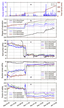
Monitoring with instruments provides better data on how much rainfall is causing landslides and when they are occurring. More importantly, monitoring also helps scientists learn how water is moving in the hillside before and during a landslide. Knowing what water is doing in hillslopes before and during landslides can lead to better tools for predicting when landslides might occur.
The data-collection system installed at a typical site is designed to collect and deliver data in near-real time and consists primarily of soil and hydrologic monitoring instrumentation, a computer, solar power, and communications equipment. The system reads and records sensor data every few minutes or seconds, depending on the type of sensor, and sends it to a central computer system where the data are downloaded, sorted, archived and graphed. Finally, the data plots are posted on the USGS Landslide Hazards web site for access by the general public. Scientists at the USGS analyze multi-year, annual, seasonal, and short-term variations in the data to learn how the hillsides respond to rainfall and how rainfall affects the potential for landslides on various time scales.
The monitoring part of the system consists of:

Not all sites have ground motion sensors, but several types of instruments can be used to observe ground movement:
- rain gages sitting on the ground surface.
- water content sensors buried at different depths vertically beneath the ground surface that measure how much of the soil's pore space is filled with water.
- two or three tensiometers (shallow, mid, deep) located in boreholes near the water content sensors that measure the amount of suction in the soil, soil-water suction is what allows damp sand to hold its shape in a sand castle and helps to hold soil on a hillside. The sensing tips of the tensiometers are placed at depths to form a vertical array.
- Piezometers installed in shallow boreholes cased with PVC at some sites where a shallow water table is present. Piezometers indicate pressure below the water table and can be used to observe changes in water table depth.
- inclinometers installed in boreholes indicate when the ground is tilting.
- lasers can indicate the movement of debris flows traveling down channels.
- seismometers that sense ground vibrations produced when a landslide occurs.
Can debris flows be predicted?
From the research using monitoring data collected at the near real-time sites, scientists have learned many more details about the interactions of rainfall (and snowmelt) and hillslopes, and are getting closer to being able to provide information for a real-time warning system.
Some of the important lessons scientists have learned are:
- Seasonal variation in soil moisture affects the susceptibility of a hillside to landslides.
- Wetness of the soil before a storm that triggers landslides affects the rainfall threshold for an area.
- Low moisture content of hillsides in the dry season allows the hillsides to tolerate much greater amounts of rainfall before sliding than during the wet season.
- Soil does not have to be completely saturated with water for landslides to occur.
- Positive pore-water pressure (which contributes to the initiation of landslides) occurs at select locations on a hillside only briefly (hours) a few times per year during heavy rainfall.
- Measurement of soil water content and water suction or pressure in hillside soils gives a more accurate estimate of slope stability than rainfall or soil water content measurements alone.
Scientists think that the onset of landslides is predictable several hours before they occur using continuous measurements of rainfall, soil water content, and soil water pressure, with the aid of mathematical models.
Scientific Staff
- Rex Baum
- Jeff Coe
- Brian Collins
- Jonathan Godt
- Jason Kean
- Joel Smith
References
- Baum, R. L. and Godt, J. W., 2010, Early warning of rainfall-induced shallow landslides and debris flows in the USA: Landslides, v. 7 no. 3, p. 259-272.
- Godt, J.W., Sener-Kaya, B., Lu, N., and Baum, R.L., 2012, Stability of infinite slopes under transient partially saturated seepage conditions: Water Resources Research, v. 48, p. WR011408.
The history of real-time monitoring for potential landslides from water and debris flows. Monitoring hillslopes with the goal of eventually establishing an early warning system for debris flows.
Water and Debris Flows
Landslides often occur in response to heavy or prolonged rainfall. On hillsides, gravity is constantly working to pull the soil and rock downslope, and rainfall infiltrating into the ground changes the forces or stresses acting on those hillside materials. If the changes in stress are large enough to overcome the strength of the hillside materials, a landslide occurs. "Debris flows" are a type of landslide initiated by heavy rainfall or rapid snowmelt; the name "debris flow" is derived from the mixture of coarse sediment that geologists call "debris" and water picked up and carried when they flow downslope or down a stream channel. When they happen, debris flows can move rapidly and travel long distances with tremendous momentum. If they occur where people and things are located they cause damage to buildings, block transportation routes, and sometimes kill or injure people. The USGS landslide scientists are trying to find better ways to determine when rainfall might cause debris flows in order to reduce their danger.
In the Past...
The link between heavy or prolonged rainfall and shallow landslides has been known for decades and began to be quantified in the late 1970s. With no monitoring instruments, however, the only data that existed were from rain gages that might be several miles from the landslides, and observations or eye-witness accounts of when landslides occurred. An eyewitness of a landslide is not common, and even if they are known to have happened, their occurrence is usually only known to the nearest day or so. In addition, the condition of the soil before the rainstorm, whether relatively dry or wet, was unknown. As a result, the links between the amount of rainfall and the timing of landslides have been inexact.
Using this inexact data, correlations known as rainfall thresholds have been developed. Rainfall thresholds are the most common tool used to forecast landslide occurrence even though their accuracy is limited due to the nature of the data.
Monitoring Hillslopes
The USGS has operated near real-time hillslope hydrologic monitoring stations in several locations across the continental U.S. for about 10 years with the goal of eventually establishing an early warning system for debris flows in cooperation with the National Weather Service. The current sites are located in Oregon, California, and North Carolina. The stations monitor rainfall and track the amount and movement of water in the upper few meters of the hillside. Some also have instruments to detect ground movement indicative of landslides. Most of these stations are operated in cooperation with universities, state and local government agencies or other partners.
Monitoring with instruments provides better data on how much rainfall is causing landslides and when they are occurring. More importantly, monitoring also helps scientists learn how water is moving in the hillside before and during a landslide. Knowing what water is doing in hillslopes before and during landslides can lead to better tools for predicting when landslides might occur.
The data-collection system installed at a typical site is designed to collect and deliver data in near-real time and consists primarily of soil and hydrologic monitoring instrumentation, a computer, solar power, and communications equipment. The system reads and records sensor data every few minutes or seconds, depending on the type of sensor, and sends it to a central computer system where the data are downloaded, sorted, archived and graphed. Finally, the data plots are posted on the USGS Landslide Hazards web site for access by the general public. Scientists at the USGS analyze multi-year, annual, seasonal, and short-term variations in the data to learn how the hillsides respond to rainfall and how rainfall affects the potential for landslides on various time scales.
The monitoring part of the system consists of:
Not all sites have ground motion sensors, but several types of instruments can be used to observe ground movement:
- rain gages sitting on the ground surface.
- water content sensors buried at different depths vertically beneath the ground surface that measure how much of the soil's pore space is filled with water.
- two or three tensiometers (shallow, mid, deep) located in boreholes near the water content sensors that measure the amount of suction in the soil, soil-water suction is what allows damp sand to hold its shape in a sand castle and helps to hold soil on a hillside. The sensing tips of the tensiometers are placed at depths to form a vertical array.
- Piezometers installed in shallow boreholes cased with PVC at some sites where a shallow water table is present. Piezometers indicate pressure below the water table and can be used to observe changes in water table depth.
- inclinometers installed in boreholes indicate when the ground is tilting.
- lasers can indicate the movement of debris flows traveling down channels.
- seismometers that sense ground vibrations produced when a landslide occurs.
Can debris flows be predicted?
From the research using monitoring data collected at the near real-time sites, scientists have learned many more details about the interactions of rainfall (and snowmelt) and hillslopes, and are getting closer to being able to provide information for a real-time warning system.
Some of the important lessons scientists have learned are:
- Seasonal variation in soil moisture affects the susceptibility of a hillside to landslides.
- Wetness of the soil before a storm that triggers landslides affects the rainfall threshold for an area.
- Low moisture content of hillsides in the dry season allows the hillsides to tolerate much greater amounts of rainfall before sliding than during the wet season.
- Soil does not have to be completely saturated with water for landslides to occur.
- Positive pore-water pressure (which contributes to the initiation of landslides) occurs at select locations on a hillside only briefly (hours) a few times per year during heavy rainfall.
- Measurement of soil water content and water suction or pressure in hillside soils gives a more accurate estimate of slope stability than rainfall or soil water content measurements alone.
Scientists think that the onset of landslides is predictable several hours before they occur using continuous measurements of rainfall, soil water content, and soil water pressure, with the aid of mathematical models.
Scientific Staff
- Rex Baum
- Jeff Coe
- Brian Collins
- Jonathan Godt
- Jason Kean
- Joel Smith
References
- Baum, R. L. and Godt, J. W., 2010, Early warning of rainfall-induced shallow landslides and debris flows in the USA: Landslides, v. 7 no. 3, p. 259-272.
- Godt, J.W., Sener-Kaya, B., Lu, N., and Baum, R.L., 2012, Stability of infinite slopes under transient partially saturated seepage conditions: Water Resources Research, v. 48, p. WR011408.