
Historical Topographic Maps - Preserving the Past
Explore Historical USGS Topographic Maps
The Historical Topographic Map Collection contains USGS topographic maps published from 1884 to 2006
topoBuilder
Create custom USGS topographic maps on demand using the best available data from The National Map
The goal of The National Map’s Historical Topographic Map Collection (HTMC) is to provide a digital repository of USGS 1:250,000 scale and larger maps printed between 1884 and 2006.
Get Topo Maps

Current US Topos and historical topographic maps are available as digital files or printed to order.
Create an OnDemand Topo
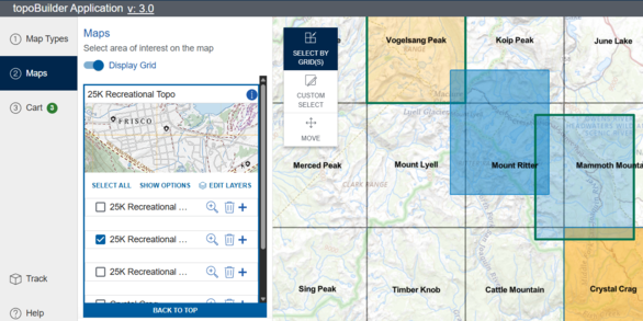
Build a USGS topographic map with choice of format, area of interest, scale, and National Map content.
Legacy U.S. Geological Survey Topographic Maps
The Historical Topographic Map Collection, or HTMC, provides a comprehensive digital repository of all scales and all editions of U.S. Geological Survey (USGS) printed topographic maps that is easily discovered, browsed, and downloaded by the public at no cost.
In 2011, the USGS National Geospatial Program began publishing scans of 1:250,000-scale and larger topographic maps printed between 1884, the inception of the topographic mapping program, and 2006, when the final maps created using traditional cartographic methods and lithographic printing processes were published. Many of these maps are no longer available for distribution in print.
Today, the HTMC contains over 185,000 high-resolution, georeferenced digital files, with accompanying metadata, representing these legacy maps.
Accessing the HTMC
The National Map Downloader is the primary portal for finding and downloading maps and other data products of the USGS National Geospatial Program.
The topoView application provides a visual overview of the HTMC and serves maps in additional formats.
The USGS Store website offers map downloads and sells prints of map files, including USGS maps and publications that are not included in either the US Topo series or HTMC.

A Glimpse into the Past
Although the historical maps may not show the current landscape, they are often useful to scientists, historians, environmentalists, genealogists, and many others as a snapshot of the nation's physical and cultural features at a particular time. A series of maps of the same area may show how it looked as early as the 1880s and provide a detailed view of changes in that area over time.
As the USGS continues the production of the current generation of topographic maps (US Topo), the topographic map remains an indispensable tool for government, science, industry, land management planning, and recreation.

Additional Resources
Download Historic Maps from The National Map
US Topo: Maps for America
National Geospatial Program Training Videos
Create Custom Topographic Maps using topoBuilder
Related

What is a GeoPDF®? What is a GeoPDF®?
A GeoPDF is a georeferenced PDF file, meaning that it is a Portable Document Format (PDF) file with added information that relates the image to coordinates on a map. GeoPDF files can be used as plain PDF files but have the added capability of some limited mapping functions (turn any map layers on and off, obtain XY coordinates for a location, measure length, and more). The USGS currently produces...

There are multiple copies of the same map in your Historical Topographic Map Collection that all have the same date. Is there a difference between those maps? There are multiple copies of the same map in your Historical Topographic Map Collection that all have the same date. Is there a difference between those maps?
Two or more historical topographic maps with the same date typically result from revisions and reprints. The differences are often minor. The date used to identify a map is in the lower right corner. If there are multiple editions with the same compilation date, look for additional dates in the lower right portion of the map collar that might differentiate them: Date on Map -- The year of base...

Why are some of the historical topographic maps yellowed and why do some have extra stamps or marks? Why are some of the historical topographic maps yellowed and why do some have extra stamps or marks?
The goals of the Historical Topographic Map Collectio n (HTMC) project are to find, catalog, and georeference all USGS topographic quadrangle maps published prior to 2007. The overall purpose is to preserve the map archive for scientists, historians, and the public. Library copies of maps (many of which have library stamps) were therefore scanned "as is". Map restoration is not part of the current...

Why are USGS historical topographic maps referenced to outdated datums? Why are USGS historical topographic maps referenced to outdated datums?
In the United States only three horizontal datums are commonly used: The North American Datum of 1927 ( NAD27) uses a starting point at a base station in Meades Ranch, Kansas and the Clarke Ellipsoid to calculate the shape of the Earth. The North American Datum of 1983 ( NAD83) was developed when satellites enabled a better model. NAD83 coordinates can be hundreds of meters away from coordinates...

Are there metadata files for USGS topographic maps? Are there metadata files for USGS topographic maps?
GeoPDF files for both Historical Topographic maps (produced 1884-2006), US Topo maps (produced 2009-present), and OnDemand Topo maps come with an XML metadata file attached to each GeoPDF file. To access the metadata file, download the GeoPDF file, open it in Acrobat Reader, click on the paperclip icon, then select a file from the list that appears (US Topo maps also come with a Map Symbols sheet...

What is GeoMark and do USGS topographic maps have it? What is GeoMark and do USGS topographic maps have it?
Almost all historical topographic maps and all US Topo maps produced before June of 2017 were georeferenced using software from the company TerraGo. Those maps are all GeoMark enabled. GeoMark is TerraGo's geospatial data extension to PDF markup. GeoMark allows notes and geometric objects (lines, polygons, etc.) to be added to a GeoPDF and allows these objects to be exported to GIS files. Users of...

Can I still get the older topographic maps? Can I still get the older topographic maps?
Yes. Topographic maps originally published as paper documents between 1884-2006 have been scanned and published as the USGS Historical Topographic Map Collection. Download our historical topographic maps and our more current US Topo maps (published 2009-present) free of charge using TopoView (GeoPDF, GeoTIFF, JPEG, and KMZ formats) or using the USGS Store’s Map Locator (GeoPDF format). Order paper...
Related
What is a GeoPDF®? What is a GeoPDF®?
A GeoPDF is a georeferenced PDF file, meaning that it is a Portable Document Format (PDF) file with added information that relates the image to coordinates on a map. GeoPDF files can be used as plain PDF files but have the added capability of some limited mapping functions (turn any map layers on and off, obtain XY coordinates for a location, measure length, and more). The USGS currently produces...
There are multiple copies of the same map in your Historical Topographic Map Collection that all have the same date. Is there a difference between those maps? There are multiple copies of the same map in your Historical Topographic Map Collection that all have the same date. Is there a difference between those maps?
Two or more historical topographic maps with the same date typically result from revisions and reprints. The differences are often minor. The date used to identify a map is in the lower right corner. If there are multiple editions with the same compilation date, look for additional dates in the lower right portion of the map collar that might differentiate them: Date on Map -- The year of base...
Why are some of the historical topographic maps yellowed and why do some have extra stamps or marks? Why are some of the historical topographic maps yellowed and why do some have extra stamps or marks?
The goals of the Historical Topographic Map Collectio n (HTMC) project are to find, catalog, and georeference all USGS topographic quadrangle maps published prior to 2007. The overall purpose is to preserve the map archive for scientists, historians, and the public. Library copies of maps (many of which have library stamps) were therefore scanned "as is". Map restoration is not part of the current...
Why are USGS historical topographic maps referenced to outdated datums? Why are USGS historical topographic maps referenced to outdated datums?
In the United States only three horizontal datums are commonly used: The North American Datum of 1927 ( NAD27) uses a starting point at a base station in Meades Ranch, Kansas and the Clarke Ellipsoid to calculate the shape of the Earth. The North American Datum of 1983 ( NAD83) was developed when satellites enabled a better model. NAD83 coordinates can be hundreds of meters away from coordinates...
Are there metadata files for USGS topographic maps? Are there metadata files for USGS topographic maps?
GeoPDF files for both Historical Topographic maps (produced 1884-2006), US Topo maps (produced 2009-present), and OnDemand Topo maps come with an XML metadata file attached to each GeoPDF file. To access the metadata file, download the GeoPDF file, open it in Acrobat Reader, click on the paperclip icon, then select a file from the list that appears (US Topo maps also come with a Map Symbols sheet...
What is GeoMark and do USGS topographic maps have it? What is GeoMark and do USGS topographic maps have it?
Almost all historical topographic maps and all US Topo maps produced before June of 2017 were georeferenced using software from the company TerraGo. Those maps are all GeoMark enabled. GeoMark is TerraGo's geospatial data extension to PDF markup. GeoMark allows notes and geometric objects (lines, polygons, etc.) to be added to a GeoPDF and allows these objects to be exported to GIS files. Users of...
Can I still get the older topographic maps? Can I still get the older topographic maps?
Yes. Topographic maps originally published as paper documents between 1884-2006 have been scanned and published as the USGS Historical Topographic Map Collection. Download our historical topographic maps and our more current US Topo maps (published 2009-present) free of charge using TopoView (GeoPDF, GeoTIFF, JPEG, and KMZ formats) or using the USGS Store’s Map Locator (GeoPDF format). Order paper...