An official website of the United States government
Here's how you know
Official websites use .gov
A .gov website belongs to an official government organization in the United States.
Secure .gov websites use HTTPS
A lock () or https:// means you’ve safely connected to the .gov website. Share sensitive information only on official, secure websites.
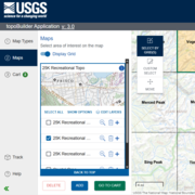
topoBuilder is a public web application released by the National Geospatial Program that enables users to request customized USGS topographic maps, known as OnDemand Topos, that utilize the best available data from The National Map.
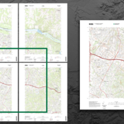
One Custom Extent OnDemand Topo (right) may cover an area that previously required up to four topo maps (left).
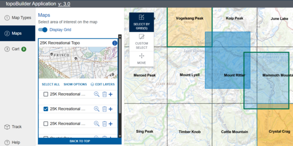
Exclusive to topoBuilder is the ability to center maps anywhere* users choose. OnDemand Topo maps do not need to align with the traditional USGS map grids so one map can cover an area that may have previously required up to four maps.
Users also have their choice of file format(georeferenced PDF or TIFF).
The Edit Layers capability lets users select which National Map layers they would like to be included in their custom map product.
Users then simply enter a valid email address and a direct link to download their unique map will be delivered free of charge. Maps are typically delivered within 24 hours but may take up to 5 business days.
OnDemand Topo Map Types
There are currently four OnDemand Topo Map Types available: The 7.5-Minute Topo, the 25K Recreational Topo, the 100K Topo, and the 250K Topo.
Custom Extent 7.5-Minute Topo map created using the topoBuilder application in January 2023.
This large-scale map type provides a high level of detail over approximately 50 to 70 square miles per map and can be used for recreation and navigation (orienteering and geocaching), city planning, search and rescue, science studies such as geologic and geographic field work, and much more.
In order to balance areal extent shown and printed product page size at varying locations on the Earth's surface, three scales are found within this map type:
1:24,000 for the contiguous United States and Hawaii
1:25,000 for Alaska
1:20,000 for Puerto Rico, the U.S. Virgin Islands, American Samoa, Guam, and the Commonwealth of the Northern Mariana Islands
An additional customization is available for 7.5-Minute Topos: Contour smoothing. Users may choose the level of contour detail best suited for their unique map needs.
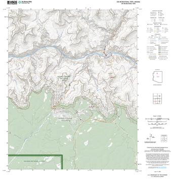
25K Recreational Topo
25K Recreational Topos are 1:25,000-scale USGS topographic maps highlighting recreational content available from The National Map.
Custom Extent 25K Recreational Topo map created using the topoBuilder application in June 2025.
Similar to the 7.5-Minute Topo, this large-scale map provides a high level of detail over approximately 50 to 70 square miles per map.
New layout with expanded legend and nationally-consistent scale improve ease of use and provide a more uniform experience from map to map.
Symbology and labeling has been highly tailored so users can more easily distinguish recreational features, such as federal land boundaries, trailheads & trails, ranger stations, picnic areas, emergency locations and more, from non-recreational features.
Enhanced contour interval algorithm for more precise terrain depiction.
Unique to the 25K Recreational Topo is the ability to show only National Trails or only Standard Trails using the Edit Layers capability.
100K Topo
100K Topos are 1:100,000-scale maps inspired by the 30- by 60-minute map series published by the USGS through the end of the 20th century.
These medium-scale maps are designed to cover an area of approximately 1,500 to 2,200 square miles and are ideal for any application where information across a large area is needed.
While 100K Topos contains less detail than the larger-scale OnDemand Topos, they provide enough information for many traditional and recreational uses as well as some science and planning applications.
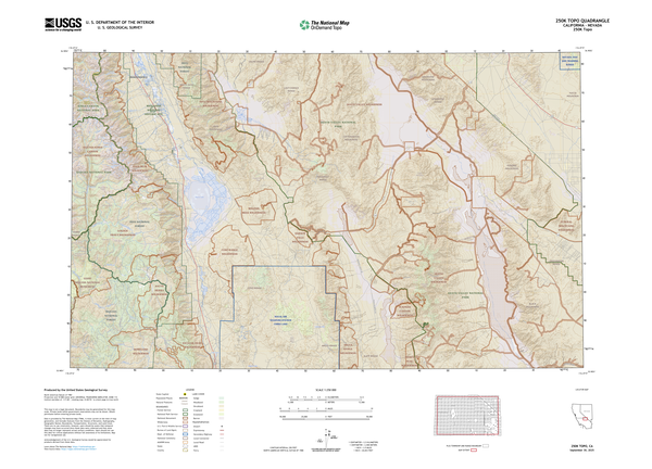
250K Topo
250K Topos are 1:250,000-scale maps inspired by the 1-degree by 2-degree map series published by USGS through the end of the 20th century.
These small-scale maps are designed to cover an area of approximately 4,500 to 8,700 square miles and are idea for any application where a view of broad geographic coverage is needed.
These maps provide a clear focus on major features and are designed to support regional planning, land and resource management, and emergency response coordination.
250K Topos include a mix of natural and built features such as cities, major roadways, political and administrative boundaries, rivers, elevation contours, land cover, geographic names, and key structures.
*OnDemand Topo maps are available within the contiguous United States, Alaska, Hawaii, Puerto Rico, the U.S. Virgin Islands, Guam, the Commonwealth of the Northern Mariana Islands, and American Samoa. OnDemand Topo coverage of the Pacific Territories is available through the 7.5-Minute Topo, 25K Recreational Topo, and 100K Topo map types only.
To learn more about map scales and how they differ in detail, content, and area coverage please visit the USGS Map Scales publication.
In order to support a consistent snapshot of National Map data, content on smaller-scale OnDemand Topos may be less current than data appearing on larger-scale OnDemand Topos.
OnDemand Topo contours and shaded relief are generated on the fly from the latest USGS elevation data, including high-quality lidar and IfSAR data acquired through the 3D Elevation Program.
7.5-Minute Topos, 100K Topos, and 250K Topos also feature additional land cover categories, such as grassland and crop/pasture, alongside the customary woodland tint.
topoBuilder is accessible via desktop computer or mobile device. Questions and feedback are welcomed by The National Map Help Desk at TNM_Help@usgs.gov.
OnDemand Topo is a digital topographic map based on a user defined Area of Interest (AOI) containing Orthoimagery, Shaded Relief, and Data from the Geographic Themes of Transportation, Hydrography, Elevation, Boundaries, Geographic Names, Structures and Land Cover.
OnDemand Topo is a digital topographic map based on a user defined Area of Interest (AOI) containing Orthoimagery, Shaded Relief, and Data from the Geographic Themes of Transportation, Hydrography, Elevation, Boundaries, Geographic Names, Structures and Land Cover.
Read about bug fixes, enhancements, and other changes to topoBuilder and OnDemand Topos. Notes on both the current and previous releases are available.
Read about bug fixes, enhancements, and other changes to topoBuilder and OnDemand Topos. Notes on both the current and previous releases are available.
Lesson 17.2 - Key Characteristics of US Topos and OnDemand Topos
This brief National Map training video compares and contrasts two U.S. Geological Survey topographic maps: US Topo and OnDemand Topo maps from the topoBuilder application. Learn more at USGS.gov/TopoMaps.
This brief National Map training video compares and contrasts two U.S. Geological Survey topographic maps: US Topo and OnDemand Topo maps from the topoBuilder application. Learn more at USGS.gov/TopoMaps.
Lesson 17.2 - Key Characteristics of US Topos and OnDemand Topos (AD)
This brief National Map training video compares and contrasts two U.S. Geological Survey topographic maps: US Topo and OnDemand Topo maps from the topoBuilder application. Learn more at USGS.gov/TopoMaps.
This brief National Map training video compares and contrasts two U.S. Geological Survey topographic maps: US Topo and OnDemand Topo maps from the topoBuilder application. Learn more at USGS.gov/TopoMaps.
This National Map training video is a brief introduction to using the topoBuilder application to build customized USGS topographic maps centered anywhere in the United States and territories that use the best available data of The National Map. Learn more at USGS.gov/topoBuilder.
This National Map training video is a brief introduction to using the topoBuilder application to build customized USGS topographic maps centered anywhere in the United States and territories that use the best available data of The National Map. Learn more at USGS.gov/topoBuilder.
This National Map training video is a brief introduction to using the topoBuilder application to build customized USGS topographic maps centered anywhere in the United States and territories that use the best available data of The National Map. Learn more at USGS.gov/topoBuilder.
This National Map training video is a brief introduction to using the topoBuilder application to build customized USGS topographic maps centered anywhere in the United States and territories that use the best available data of The National Map. Learn more at USGS.gov/topoBuilder.
The U.S. Geological Survey’s National Geospatial Program has released the topoBuilder application, which enables users to create topographic maps on demand using the best available National Map data.
The U.S. Geological Survey’s National Geospatial Program has released the topoBuilder application, which enables users to create topographic maps on demand using the best available National Map data.
TopoBuilder is a public web application from the National Geospatial Program that enables anyone to create customized digital U.S. Geological Survey (USGS) topographic maps, called OnDemand Topos, with the best available, most up-to-date data from The National Map (nationalmap.gov). OnDemand Topos can be made at different scales or quadrangles and can cover anywhere within the United...
Authors
Elaine Guidero, Ariel T. Doumbouya, Karen F. Adkins, Brigitta Urban-Mathieux
OnDemand Topo map users now have more map scale options available to them with debut of the 100K Topo or 1:100,000-scale mapping capability within the free topoBuilder application.
Adventure awaits: USGS releases detailed topographic maps designed for recreational use
For outdoor enthusiasts, hikers, and adventurers, maps are more than just a tool – they are a gateway to exploration. The U.S. Geological Survey has...
OnDemand Topo Maps Officially Join USGS National Map Offerings
The people have spoken! OnDemand Topo maps and topoBuilder were so popular that we're ending the pilot phase of the project and making topoBuilder a...
The distinctive characteristic of a topographic map is the use of elevation contour lines to show the shape of the Earth's surface. Elevation contours are imaginary lines connecting points having the same elevation on the surface of the land above or below a reference surface, which is usually mean sea level. Contours make it possible to show the height and shape of mountains, the depths of the...
The distinctive characteristic of a topographic map is the use of elevation contour lines to show the shape of the Earth's surface. Elevation contours are imaginary lines connecting points having the same elevation on the surface of the land above or below a reference surface, which is usually mean sea level. Contours make it possible to show the height and shape of mountains, the depths of the...
OnDemand Topos are USGS topographic maps generated on demand (at no cost) using the topoBuilder application and the best available data from The National Map. The ability to customize your map and center it wherever you choose is exclusive to topoBuilder. OnDemand Topo map extents do not need to align with the traditional grids utilized by US Topos and other USGS topographic maps. Once a map has...
OnDemand Topos are USGS topographic maps generated on demand (at no cost) using the topoBuilder application and the best available data from The National Map. The ability to customize your map and center it wherever you choose is exclusive to topoBuilder. OnDemand Topo map extents do not need to align with the traditional grids utilized by US Topos and other USGS topographic maps. Once a map has...
USGS OnDemand Topo maps and USGS US Topo maps are built using similar datasets but can look different depending on what areas or options the user selects. OnDemand Topos--created using the topoBuilder application--offer customizations such as custom extents, a variety of scales, contour smoothing, and user-selected data layers. They include U.S. Territory coverage that is not available on US...
How do USGS OnDemand Topo maps differ from US Topo maps?
USGS OnDemand Topo maps and USGS US Topo maps are built using similar datasets but can look different depending on what areas or options the user selects. OnDemand Topos--created using the topoBuilder application--offer customizations such as custom extents, a variety of scales, contour smoothing, and user-selected data layers. They include U.S. Territory coverage that is not available on US...


")

")