
ModelMuse screen capture to be used as a thumbnail for a video about creating meshes.
Images
Discover and download images related to the Water Availability and Use Science Program.
Filter Total Items: 76

Generating a Mesh in ModelMuse
ModelMuse screen capture to be used as a thumbnail for a video about creating meshes.

SUTRA Boundary Conditions and Observations
Screen capture of ModelMuse with the words "Objects are used to specify boundary conditions and observations."
Screen capture of ModelMuse with the words "Objects are used to specify boundary conditions and observations."

SUTRA Time Schedules
This image is a screen capture of ModelMuse with the words "To define time schedules, select 'ModelSUTRA Time Controls.'"
This image is a screen capture of ModelMuse with the words "To define time schedules, select 'ModelSUTRA Time Controls.'"

Permeability in SUTRA
Screen capture of ModelMuse with a visualization of the SUTRA permeability. The image is intended to be used as a thumbnail for a video.
Screen capture of ModelMuse with a visualization of the SUTRA permeability. The image is intended to be used as a thumbnail for a video.

Starting a new SUTRA model
ModelMuse screen capture with the text "This is the first of several videos that give an introduction to working with SUTRA in ModelMuse."
ModelMuse screen capture with the text "This is the first of several videos that give an introduction to working with SUTRA in ModelMuse."

Main changes to the ModelMuse main window with SUTRA
Main changes to the ModelMuse main window with SUTRAThis video describes some of the most obvious changes to ModelMuse when working with SUTRA models.
Main changes to the ModelMuse main window with SUTRA
Main changes to the ModelMuse main window with SUTRAThis video describes some of the most obvious changes to ModelMuse when working with SUTRA models.

Running SUTRA and Displaying Model Results
ModelMuse screen capture with the words "This video will show how to run SUTRA and view the model results."
ModelMuse screen capture with the words "This video will show how to run SUTRA and view the model results."

Nodes and Elements in SUTRA
Screen capture of ModelMuse with a mesh and the words "In SUTRA, some data are specified at nodes and some data are specified at elements."
Screen capture of ModelMuse with a mesh and the words "In SUTRA, some data are specified at nodes and some data are specified at elements."

Drought Conditions in the lower Apalachicola-Chattahoochee-Flint River
Drought Conditions in the lower Apalachicola-Chattahoochee-Flint RiverDrought Conditions in the lower Apalachicola-Chattahoochee-Flint River Basin in July 2011: USGS measured streamflow at 267 sites in the lower ACF Basin and western and central parts of the Aucilla–Suwanee–Ochlockonee River basin during July 2011 to measure the effects of drought and irrigation withdrawals on streamflow.

Center pivot irrigation system watering a cornfield in Arizona
Center pivot irrigation system watering a cornfield in ArizonaCenter pivot irrigation system watering a cornfield in Arizona
Center pivot irrigation system watering a cornfield in Arizona
Center pivot irrigation system watering a cornfield in ArizonaCenter pivot irrigation system watering a cornfield in Arizona

Steve Peterson making a stream discharge measurement.
Steve Peterson making a stream discharge measurement.USGS Nebraska Water Science Center Elkhorn-Loup Model project chief, Steve Peterson, making a stream discharge measurement. The project collected hundreds of discharge measurements in 2006 to determine base flow in the study area.
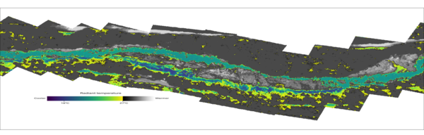
Thermal infrared mosaic of Quartzville Creek, OR
Thermal infrared mosaic of Quartzville Creek, OR. These images were captured on the year 2000 as part of an airborne thermal infrared survey conducted in the Santiam River basin, OR. The images were orthorectified and mosaicked into a single raster in order to identify and visualize thermal heterogeneity.
Thermal infrared mosaic of Quartzville Creek, OR. These images were captured on the year 2000 as part of an airborne thermal infrared survey conducted in the Santiam River basin, OR. The images were orthorectified and mosaicked into a single raster in order to identify and visualize thermal heterogeneity.

Historic Chicago water tower.
The historic water tower in Chicago, IL, built in 1869 and now a museum.
The historic water tower in Chicago, IL, built in 1869 and now a museum.