Artesian Well (cropped), John Pennekamp Coral Reef State Park, Key Lar
Artesian Well (cropped), John Pennekamp Coral Reef State Park, Key LarArtesian Well (cropped), John Pennekamp Coral Reef State Park, Key Largo, FL

Official websites use .gov
A .gov website belongs to an official government organization in the United States.
Secure .gov websites use HTTPS
A lock () or https:// means you’ve safely connected to the .gov website. Share sensitive information only on official, secure websites.
Discover and download images related to the Water Availability and Use Science Program.

Artesian Well (cropped), John Pennekamp Coral Reef State Park, Key Largo, FL
Artesian Well (cropped), John Pennekamp Coral Reef State Park, Key Largo, FL

Industrial water use in 2015

Salt Deposits (Gypsum). (Source: Siim Sepp, http://www.sandatlas.org/)

Components of a simple water budget for part of a watershed, from Healy, R.W., Winter, T.C., LaBaugh, J.W., and Franke, O.L., 2007, Water budgets: Foundations for effective water-resources and environmental management: U.S. Geological Survey Circular 1308.
Components of a simple water budget for part of a watershed, from Healy, R.W., Winter, T.C., LaBaugh, J.W., and Franke, O.L., 2007, Water budgets: Foundations for effective water-resources and environmental management: U.S. Geological Survey Circular 1308.

Yellowstone River Valley, northeast of Billings, from 37,002 feet, Delta Flight 610, Seattle to Atlanta, Yellowstone County, Montana . Photograph by Alan Cressler, USGS
Yellowstone River Valley, northeast of Billings, from 37,002 feet, Delta Flight 610, Seattle to Atlanta, Yellowstone County, Montana . Photograph by Alan Cressler, USGS

Map of Water Availability and Use Program Studies from USGS Circular 1440 "Continuing Progress toward a national Assessment of Water Availability and Use."
Map of Water Availability and Use Program Studies from USGS Circular 1440 "Continuing Progress toward a national Assessment of Water Availability and Use."

Example water budget visualization for Buck Creek-Delaware River showing the difference between inflow and outflow components. Full visualization application is located at https://cida.usgs.gov/nwc-static/waterbudget-viz/
Example water budget visualization for Buck Creek-Delaware River showing the difference between inflow and outflow components. Full visualization application is located at https://cida.usgs.gov/nwc-static/waterbudget-viz/

Map of the U.S. by state, showing total water withdrawals, 2015
Map of the U.S. by state, showing total water withdrawals, 2015

Source and Use of Freshwater in the United States, 2015
This diagram uses a "cylinder and pipe" layout to show the source (surface water or groundwater) of the Nation's freshwater and for what purposes the water was used in 2015. The data are broken out for each category of use by surface water and groundwater as the source.

Bar chart showing use of water in 2015, by state and category of use
Bar chart showing use of water in 2015, by state and category of use

Source and Use of Water in the United States, 2015
This diagram uses a "cylinder and pipe" layout to show the source (surface water or groundwater) of the Nation's water and for what purposes the water was used in 2015. The data are broken out for each category of use by surface water and groundwater as the source.

Real-time flow meter installed on a center-pivot irrigation well in Mississippi County, Arkansas as part of a cooperative project conducted between USGS and the Arkansas Natural Resources Commission. The meter will measure water use for irrigation, providing data which will help improve water-use information in other locations as well.
Real-time flow meter installed on a center-pivot irrigation well in Mississippi County, Arkansas as part of a cooperative project conducted between USGS and the Arkansas Natural Resources Commission. The meter will measure water use for irrigation, providing data which will help improve water-use information in other locations as well.

Chattooga River, Middle Gorge, Wild and Scenic River, Jackson County, North Carolina
Chattooga River, Middle Gorge, Wild and Scenic River, Jackson County, North Carolina

USGS Hydrologic Technician Kim Cesal measuring 3170 cfs at 12409000 Colville River at Kettle Falls, WA. This measurement is the highest made at the gaging site. The gage has been in operation since October 1922. The gage was installed to monitor flows from Meyer Falls Dam and Power Generation.
USGS Hydrologic Technician Kim Cesal measuring 3170 cfs at 12409000 Colville River at Kettle Falls, WA. This measurement is the highest made at the gaging site. The gage has been in operation since October 1922. The gage was installed to monitor flows from Meyer Falls Dam and Power Generation.
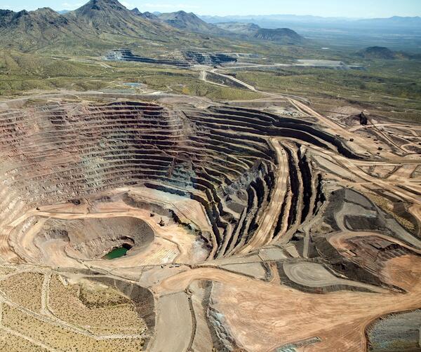
Photograph of Freeport McMoRan-Safford Copper Mine in Arizona. Photograph taken by Thomas J. Porter (USGS) on September 19, 2016, Latitude 32.85992 deg N, Longitude -109.622
Photograph of Freeport McMoRan-Safford Copper Mine in Arizona. Photograph taken by Thomas J. Porter (USGS) on September 19, 2016, Latitude 32.85992 deg N, Longitude -109.622

Water flowing on the Colorado River near Moab, Utah.
The entire Colorado River Basin currently supports 50 million people, and that amount is expected to increase by 23 million between 2000 and 2030. A new USGS study shows more than half of the streamflow in the Upper Colorado River Basin originates as groundwater.

Thermoelectric power plant Bowen owned by Georgia Power Company, from Highway 113, Euharlee, Bartow County, Georgia. Plant Bowen is one of the largest coal-fired power plants in the United States. Plant Bowen uses recirculating cooling, decreasing the amount of water that must be withdrawn.
Thermoelectric power plant Bowen owned by Georgia Power Company, from Highway 113, Euharlee, Bartow County, Georgia. Plant Bowen is one of the largest coal-fired power plants in the United States. Plant Bowen uses recirculating cooling, decreasing the amount of water that must be withdrawn.

Trask River stage, discharge, and water-quality data are collected and used together to help monitor the current health of the river. Instream equipment is stored in protective housing to protect it from the elements. Data from the river are sent to equipment in the gage house, where it is stored then transmitted to USGS servers.
Trask River stage, discharge, and water-quality data are collected and used together to help monitor the current health of the river. Instream equipment is stored in protective housing to protect it from the elements. Data from the river are sent to equipment in the gage house, where it is stored then transmitted to USGS servers.

Screen capture of ModelMuse with a mesh for SUTRA being generated by GMSH. This image is intended to be used as a thumbnail for a video.
Screen capture of ModelMuse with a mesh for SUTRA being generated by GMSH. This image is intended to be used as a thumbnail for a video.

Etowah River, Bartow County, Georgia

The confluence of the Suiattle River (muddy river) into the Sauk River.
The confluence of the Suiattle River (muddy river) into the Sauk River.