
Ohio River at Ironton - super gage installation. The gage is located in the upper part of the tower shown in the background.
Images
Images
Filter Total Items: 655

Ohio River at Ironton, OH
Ohio River at Ironton - super gage installation. The gage is located in the upper part of the tower shown in the background.

Ohio River at Ironton, OH - wire weight gage
Ohio River at Ironton, OH - wire weight gage

A storm drain that periodically discharges urban runoff
A storm drain that periodically discharges urban runoffA storm drain that periodically discharges urban runoff, potentially carrying sediment and pollutants, into Oak Creek at 15th Avenue near a USGS gage.
A storm drain that periodically discharges urban runoff
A storm drain that periodically discharges urban runoffA storm drain that periodically discharges urban runoff, potentially carrying sediment and pollutants, into Oak Creek at 15th Avenue near a USGS gage.

2019 GLB NOSB 1st Place Winner Troy High School
2019 GLB NOSB 1st Place Winner Troy High School.
2019 GLB NOSB 1st Place Winner Troy High School.
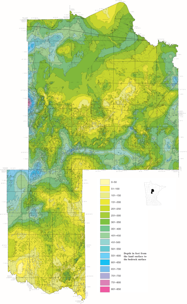
Cass County, Minnesota Depth to Bedrock map
This map shows the depth to bedrock for Cass County, Minnesota which represents the thickness of unconsolidated sediment above bedrock. It is part of the County Geologic Atlas project being conducted by the Minnesota Geological Survey. Maps like these help provide information about the glacial deposits that overlie the bedrock.
This map shows the depth to bedrock for Cass County, Minnesota which represents the thickness of unconsolidated sediment above bedrock. It is part of the County Geologic Atlas project being conducted by the Minnesota Geological Survey. Maps like these help provide information about the glacial deposits that overlie the bedrock.

Cuyahoga River at Independence OH - view from edge of river
Cuyahoga River at Independence OH - view from edge of riverCuyahoga River at Independence OH - view from edge of river
Cuyahoga River at Independence OH - view from edge of river
Cuyahoga River at Independence OH - view from edge of riverCuyahoga River at Independence OH - view from edge of river
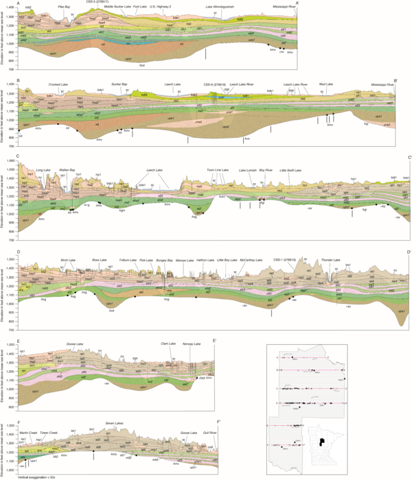
Cass County, Minnesota Quaternary Stratigraphy Cross Sections
Cass County, Minnesota Quaternary Stratigraphy Cross SectionsThis diagram depicts the Quaternary Stratigraphy of Cass County, Minnesota shown in six different cross sections located throughout Cass County, MN as indicated in the bottom right indicator map. These cross sections are representative of the materials to be encountered between the land surface and bedrock.

Confined disposal facility, East Chicago, Indiana
Front cover for the publication titled "Geochemistry and microbiology of groundwater and solids from extraction and monitoring wells and their relation to well efficiency at a Federally operated confined disposal facility, East Chicago, Indiana"
Front cover for the publication titled "Geochemistry and microbiology of groundwater and solids from extraction and monitoring wells and their relation to well efficiency at a Federally operated confined disposal facility, East Chicago, Indiana"

Chippewa Dunes Multibeam Survey - downstream of Durand bridge
Chippewa Dunes Multibeam Survey - downstream of Durand bridgeChippewa Dunes Multibeam Survey downstream of Durand bridge.
Chippewa Dunes Multibeam Survey - downstream of Durand bridge
Chippewa Dunes Multibeam Survey - downstream of Durand bridgeChippewa Dunes Multibeam Survey downstream of Durand bridge.

The Autonomous Underwater Vehicle Ready to Deploy
The underwater autonomous vehicle sitting in a parking lot before being deployed.
The underwater autonomous vehicle sitting in a parking lot before being deployed.

The Autonomous Underwater Vehicle (AUV) in testing
The Autonomous Underwater Vehicle (AUV) in testingThis is the autonomous underwater vehicle (AUV). Here, it is being tested in a hotel swimming pool.
The Autonomous Underwater Vehicle (AUV) in testing
The Autonomous Underwater Vehicle (AUV) in testingThis is the autonomous underwater vehicle (AUV). Here, it is being tested in a hotel swimming pool.

Eagle Creek at Zionsville, IN - downstream of gage
Eagle Creek at Zionsville, IN - downstream of gageEagle Creek at Zionsville, IN - downstream of gage
Eagle Creek at Zionsville, IN - downstream of gage
Eagle Creek at Zionsville, IN - downstream of gageEagle Creek at Zionsville, IN - downstream of gage

The GLSC Aquatic Laboratory
Dr. Wendy Stott (GLSC) discusses the science carried out in the Ann Arbor aquatic research laboratory.
Dr. Wendy Stott (GLSC) discusses the science carried out in the Ann Arbor aquatic research laboratory.

Phragmites australis on the Shore of Lake St. Clair
Phragmites australis on the Shore of Lake St. ClairPhragmites australis on the Shore of Lake St. Clair, 2015
Phragmites australis on the Shore of Lake St. Clair
Phragmites australis on the Shore of Lake St. ClairPhragmites australis on the Shore of Lake St. Clair, 2015

Moffett Award Presented to Yu-Chun Kao
GLSC Director Russ Strach presents the 2018 GLSC Moffett Award to lead author Yu-Chun Kao for his 2017 paper, Evaluating Stocking Efficacy in an Ecosystem Undergoing Oligotrophication, with GLSC coauthors Mark Rogers and David “Bo” Bunnell.
GLSC Director Russ Strach presents the 2018 GLSC Moffett Award to lead author Yu-Chun Kao for his 2017 paper, Evaluating Stocking Efficacy in an Ecosystem Undergoing Oligotrophication, with GLSC coauthors Mark Rogers and David “Bo” Bunnell.

USGS Columbus, Ohio office
The USGS Ohio Water Science Center located in Colubumbus, Ohio. The OH WSC is part of the Ohio-Kentucky-Indiana WSC.
The USGS Ohio Water Science Center located in Colubumbus, Ohio. The OH WSC is part of the Ohio-Kentucky-Indiana WSC.

GLSC Greenhouse
GLSC’s Aaron DeVries and Mckenzie Smith, left, discuss innovative controls for invasive Phragmites australis in GLSC’s greenhouse facility.
GLSC’s Aaron DeVries and Mckenzie Smith, left, discuss innovative controls for invasive Phragmites australis in GLSC’s greenhouse facility.

Bank erosion along an upstream reach of the Kinnickinnic River
Bank erosion along an upstream reach of the Kinnickinnic RiverBank erosion along an upstream reach of the Kinnickinnic River, October 2018.
Bank erosion along an upstream reach of the Kinnickinnic River
Bank erosion along an upstream reach of the Kinnickinnic RiverBank erosion along an upstream reach of the Kinnickinnic River, October 2018.

Lake Michigan lake bottom and the corner of a pivot point
Lake Michigan lake bottom and the corner of a pivot pointLake Michigan lake-bottom near South Manitou Island. Visible is part of a diver's hand and the corner of a anchor point used for circular transects.
Lake Michigan lake bottom and the corner of a pivot point
Lake Michigan lake bottom and the corner of a pivot pointLake Michigan lake-bottom near South Manitou Island. Visible is part of a diver's hand and the corner of a anchor point used for circular transects.

Deploying Underwater Camera in Lake Michigan
USGS personnel: Sam Pecoraro (left), Tanner Kenney (middle), and Scott Dwyer (right; in the water) deploying an underwater camera in Lake Michigan near South Manitou Island.
USGS personnel: Sam Pecoraro (left), Tanner Kenney (middle), and Scott Dwyer (right; in the water) deploying an underwater camera in Lake Michigan near South Manitou Island.

A center pivot is used for circular transects
A diver is holding onto a pole which is used as a pivot point. A line can be seen that a diver attachs to a camera for running circular transects. Image taken in Lake Michigan near South Manitou Island.
A diver is holding onto a pole which is used as a pivot point. A line can be seen that a diver attachs to a camera for running circular transects. Image taken in Lake Michigan near South Manitou Island.