
Topobathymetric Elevation Model of Northern Gulf of America
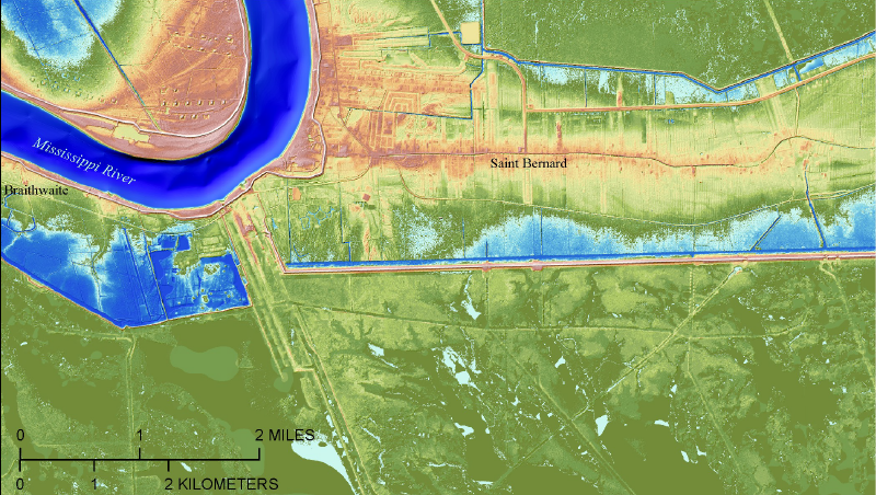
Accurate, high-resolution elevation information is vital to understanding the highly dynamic northern Gulf of America coast, the location of North America’s largest delta system and the focus of one of the largest coastal restoration and flood risk reduction efforts in the United States. The northern Gulf of America topobathymetric digital elevation model (TBDEM) was developed in collaboration between U.S. Geological Survey (USGS) Coastal and Marine Geology Program, USGS National Geospatial Program, Coastal Protection and Restoration Authority of Louisiana, and a number of federal, state, and parish agencies to create a comprehensive high-resolution, three-dimensional (3D) TBDEM for the northern Gulf of America.
This TBDEM seamlessly integrates over 400 land elevation and water depth (bathymetry) datasets collected from 1888 to 2013 by USGS, U.S. Army Corps of Engineers, National Oceanic and Atmospheric Administration (NOAA), and other organizations. The topographic data were obtained primarily from USGS National Elevation Dataset, USGS Experimental Advanced Airborne Research Lidar (EAARL) data, and topographic lidar data and TBDEMs from NOAA. This 3D integrated TBDEM consists of a detailed and highly accurate elevation model incorporating the best available multi-source topographic and bathymetric elevation data for the northern Gulf of America.
Additional information about topobathymetric elevation models is available online at USGS EROS Archive - Digital Elevation - Coastal National Elevation Database (CoNED) Project - Topobathymetric Digital Elevation Model (TBDEM).
To view or download the northern Gulf of America topobathymetric elevation model, visit the CoNED Project Viewer.


Below are other science projects associated with this project.

Coastal National Elevation Database (CoNED) Applications Project
Coastal National Elevation Database (CoNED) Applications Project
Accurate, high-resolution elevation information is vital to understanding the highly dynamic northern Gulf of America coast, the location of North America’s largest delta system and the focus of one of the largest coastal restoration and flood risk reduction efforts in the United States. The northern Gulf of America topobathymetric digital elevation model (TBDEM) was developed in collaboration between U.S. Geological Survey (USGS) Coastal and Marine Geology Program, USGS National Geospatial Program, Coastal Protection and Restoration Authority of Louisiana, and a number of federal, state, and parish agencies to create a comprehensive high-resolution, three-dimensional (3D) TBDEM for the northern Gulf of America.
This TBDEM seamlessly integrates over 400 land elevation and water depth (bathymetry) datasets collected from 1888 to 2013 by USGS, U.S. Army Corps of Engineers, National Oceanic and Atmospheric Administration (NOAA), and other organizations. The topographic data were obtained primarily from USGS National Elevation Dataset, USGS Experimental Advanced Airborne Research Lidar (EAARL) data, and topographic lidar data and TBDEMs from NOAA. This 3D integrated TBDEM consists of a detailed and highly accurate elevation model incorporating the best available multi-source topographic and bathymetric elevation data for the northern Gulf of America.
Additional information about topobathymetric elevation models is available online at USGS EROS Archive - Digital Elevation - Coastal National Elevation Database (CoNED) Project - Topobathymetric Digital Elevation Model (TBDEM).
To view or download the northern Gulf of America topobathymetric elevation model, visit the CoNED Project Viewer.
Below are other science projects associated with this project.
Coastal National Elevation Database (CoNED) Applications Project