
Data Preservation and Dissemination
Earth MRI works with partners to revive old data and materials for use in today’s world and for generations to come.
Today’s world contains increasingly sophisticated tools for understanding the Earth and its resources, but using these tools relies on access to large quantities of digitally usable geologic data. Earth MRI is committed to data preservation, dissemination and usability. This includes disseminating and preserving data as it is collected, as well as recovering, digitizing, and disseminating historic geologic data.
Partnerships for Preservation and Digitization
Earth MRI partners with the National Geological and Geophysical Data Preservation Program to preserve and disseminate historical records and geologic samples that are stored in state archives. These records may provide useful information about critical mineral resources, including locations and other collection data about geologic materials such as rock samples or cores collected through drilling.
Earth MRI supports chemical re-analysis of archived samples using modern methods to identify the critical elements that they might contain. Preserved materials are cataloged in a Registry of Scientific Collections that provides information about the preserved assets and how they may be accessed by the public for geoscientific research. The locations of geologic cores and information about subsurface materials (cores, cuttings, etc.) are indexed in the National Index of Borehole Information, which also promotes the searchability, discoverability, accessibility, and re-use of these assets.
The Earth MRI Acquisitions Viewer and Other Hubs
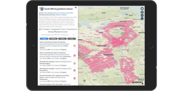
Earth MRI connects to the public through an interactive web-based map tool, the Earth MRI Acquisitions Viewer, that shows all of the active and completed projects across the Nation, describes the activities and motivations, and links to the resulting data for completed projects.
Earth MRI also partners with other USGS data dissemination hubs such as the National Geologic Map Database and USGS Geochron to provide access to geologic maps and high-quality data related to geochronology and thermochronology. New databases and web tools are in development that will provide access to other Earth MRI data streams including geochemistry, geophysics, and hyperspectral remote sensing.