
Hyperspectral Mapping
Hyperspectral surveys allow scientists to identify minerals exposed at the surface of the Earth, among other applications.
Light travels at many wavelengths, only some of which human eyes can see. Hyperspectral surveys capture light that is reflected off the Earth’s surface within and beyond the spectrum of visible light.
For instance, hyperspectral surveys also capture infrared, near-infrared and ultraviolet light.
We collect hyperspectral data in many ways: via high-altitude airplanes, lower-level flights and drones. In partnership with NASA, we are collecting hypespectral data using high-altitude airplanes equipped with extremely sensitive sensors. Earth MRI also collects district-scale commercial hyperspectral data and drone data to study mine waste and heavy mineral sands.
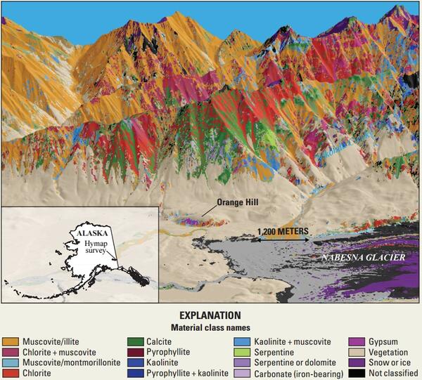
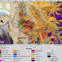
These large hyperspectral surveys can be used to identify specific patterns of light absorption that are associated with different minerals, soils and even different kinds of vegetation. The USGS has discerned these patterns of light absorption - sometimes called “spectral fingerprints” - for thousands of materials in the USGS Spectral Library. Scientists can use the Spectral Library to “read” hyperspectral data and identify materials across a large swath of land: a task that would otherwise require decades – or even centuries – of fieldwork.
Learn more!
-
Seeing the Earth in a new light: How Earth MRI data is deepening our understanding of minerals on the landscape Seeing the Earth in a new light: How Earth MRI data is deepening our understanding of minerals on the landscape
Twelve miles above the American southwest, a pilot in a pressurized spacesuit navigates through the stratosphere in a high-altitude aircraft, measuring light reflected off the Earth’s surface.